Difference between revisions of "2012-01-26 57 14"
imported>Cjk ([live picture] Clear cut) |
m (per Renaming Proposal) |
||
| (16 intermediate revisions by 3 users not shown) | |||
| Line 1: | Line 1: | ||
| + | [[Image:{{{image|2012-01-26_57_14_14-46-55-688.jpg}}}|thumb|left]] | ||
| − | |||
| − | |||
| − | |||
| − | |||
| − | |||
| − | |||
| − | |||
| − | |||
| − | |||
{{meetup graticule | {{meetup graticule | ||
| lat=57 | | lat=57 | ||
| Line 19: | Line 11: | ||
== Location == | == Location == | ||
<!-- where you've surveyed the hash to be --> | <!-- where you've surveyed the hash to be --> | ||
| + | Straight into the woods off the end of a logging road SE of Värnamo.. | ||
== Participants == | == Participants == | ||
<!-- who attended --> | <!-- who attended --> | ||
| + | [[User:Cjk|Carl-Johan]] | ||
== Plans == | == Plans == | ||
<!-- what were the original plans --> | <!-- what were the original plans --> | ||
| + | To deflower 2 [[Virgin Graticule|virgin graticules]] and maybe work on my minesweeper around [[Västerås, Sweden]] making this a triple hash. [https://maps.google.com/maps?saddr=R%C3%B6san,+Onsala,+Sverige&daddr=57.0735521,13.0477922+to:57.0662319,13.0887601+to:57.0763577,+13.0874229+to:57.056284,13.118041+to:57.1214,13.37995+to:57.160525,13.414299+to:57.0763577,+14.0874229+to:57.16294,14.07451+to:57.1613372,14.0773533+to:59.0763577,+16.0874229+to:59.0775361,16.0880843+to:59.34386,18.02204+to:Grevgatan,+Stockholm,+Sverige&hl=en&ie=UTF8&sll=59.328636,18.058434&sspn=0.066288,0.138359&geocode=FR_EawMdk0S3ACl_kVeG48JPRjFccDXFdAjuUQ%3BFZDfZgMd8BfHACmV9GpE5lFQRjE-1NTvvNnPfA%3BFffCZgMd-LfHACm_Mpbbm1FQRjHQ0VYIeJABEw%3BFYbqZgMdv7LHAA%3BFRycZgMdWSrIACkHL2PwZFFQRjHQ61YIeJABEw%3BFXiaZwMdbinMAClVKHlCjfdQRjF8eynGy3MXBg%3BFU0zaAMdm6_MAClPFQ4xTvZQRjGRkXQIeJABEw%3BFYbqZgMd__TWAA%3BFbw8aAMdjsLWACmR1ActLMFQRjHQTrYQeJABEw%3BFXk2aAMdqc3WAClDxLtgLcFQRjFl23agI1wTvA%3BFQZvhQMdf3n1AA%3BFaBzhQMdFHz1ACkv-D07srteRjGh9GEX8_4AEw%3BFfSDiQMdmP4SASlRP348g51fRjESIXBrWHzwFg%3BFUZjiQMdSvcTASl78vQbUJ1fRjFt09J_yehrdw&oq=R%C3%B6san+onsala&mra=dpe&mrsp=12&sz=13&via=1,2,4,5,6,8,9,11,12&t=m&z=13 This] was the route I took. | ||
| + | |||
| + | *[[2012-01-26 57 13]] Virgin Graticule for [[Gislaved, Sweden]] | ||
| + | *[[2012-01-26 57 14]] Virgin Graticule for [[Jönköping, Sweden]] | ||
| + | *[[2012-01-26 59 16]] | ||
| + | |||
== Expedition == | == Expedition == | ||
<!-- how it all turned out. your narrative goes here. --> | <!-- how it all turned out. your narrative goes here. --> | ||
| + | Coming from [[2012-01-26 57 13]] I hopped back into the car and headed south out to a bigger road that took me back to the 153. Once on the 153 it was an easy drive to Värnamo. Saw a Max Hamburgers and Biltema just by the E4 as i was passing it and those will come in handy later. Was going to turn off onto kyrkvägen but a friend called just 30 seconds before so I missed the road by 1.5 km. Backtrack and onto the right one. And then into the woods. Passed a pickup where someone probably was working in the woods and over a huge clear cut. The road ends and I get out. It should be an easy 187 m following the straight line that the road took I think. | ||
| + | |||
| + | '''OH HOW WRONG I WAS!''' | ||
| + | |||
| + | Unlike the last geohash, where the spruce was old, tall and culled so there was no underbrush, this was totally overgrown. Trees every single meter in every direction. And they were snowy! And I had to duck into them. And the sky had grayed over in anticipation of the oncoming blizzard I was going to have to drive through on the way to Katrineholm and Stockholm. | ||
| + | |||
| + | *Totally featureless sky, check | ||
| + | *Trees everywhere so you can't see the forest for all the trees, check | ||
| + | *Snow on everything so everything is white, check | ||
| + | *Losing all sense of direction, check | ||
| + | |||
| + | Of course the tall trees were messing with the GPS again, but not crazy much, but I actually got a bit lost wandering the last 20 meters. I thought I was going east at one point, towards the hash, but I was going west and I noticed it cause I was getting further away from the hash, not closer. Nothing to get scared about, I could always just use my tracks to get back to the car, but it felt crazy loosing your sense of direction so bad since I had no point of reference at all. | ||
| + | |||
| + | I found the spot about a minute later, and the GPS in the phone was bouncing me around a bit but it stabilized in a very very tiny clearing. See the panoramas how cramped it is. That was like the biggest clearing in the whole patch of forest. Some pics and then back to the car. On the way to the hash I had to jump a creek, and it turned out it was a bit wider than I had thought. I had made the jump with cm to spare so on the way back i found a narrower spot. | ||
| + | |||
| + | Headed back to Max to get lunch and bought a some supplies at Biltema, especially a flashlight so I always can have one in the car. I know it is about to get very dark before [[2012-01-26 59 16]]. | ||
*Deflowered -- [[User:Cjk|Cjk]] [http://www.openstreetmap.org/?lat=57.07635918&lon=14.08739165&zoom=16&layers=B000FTF @57.0764,14.0874] 08:39, 26 January 2012 (EST) | *Deflowered -- [[User:Cjk|Cjk]] [http://www.openstreetmap.org/?lat=57.07635918&lon=14.08739165&zoom=16&layers=B000FTF @57.0764,14.0874] 08:39, 26 January 2012 (EST) | ||
| − | |||
| − | |||
== Photos == | == Photos == | ||
| Line 39: | Line 53: | ||
--> | --> | ||
<gallery perrow="5"> | <gallery perrow="5"> | ||
| − | |||
| − | |||
Image:2012-01-26_57_14_15-20-41-609.jpg | Frozen. -1 C | Image:2012-01-26_57_14_15-20-41-609.jpg | Frozen. -1 C | ||
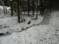
Image:2012-01-26_57_14_22-46-32-144.jpg | Clear cut | Image:2012-01-26_57_14_22-46-32-144.jpg | Clear cut | ||
| + | |||
| + | Image:2012-01-26_57_14_22-47-07-236.jpg | Weirdo contraption. | ||
| + | |||
| + | Image:2012-01-26_57_14_22-48-15-922.jpg | Into the spruces | ||
| + | |||
| + | Image:2012-01-26_57_14_14-46-55-688.jpg | [https://www.youtube.com/watch?gl=US&v=lzmYr_wzikg Hot Snakes] and lost in woods [http://www.openstreetmap.org/?lat=57.07630000&lon=14.08740000&zoom=16&layers=B000FTF @57.0763,14.0874] | ||
| + | |||
| + | Image:2012-01-26_57_14_22-48-50-834.jpg | Stupid grin | ||
| + | |||
| + | Image:2012-01-26_57_14_22-49-50-199.jpg | Dense forest! | ||
| + | |||
| + | Image:2012-01-26_57_14_22-50-29-587.jpg | Way out? | ||
| + | |||
| + | Image:2012-01-26_57_14_22-55-11-565.jpg | Follow footprints out. | ||
| + | |||
| + | Image:2012-01-26_57_14_22-55-47-911.jpg | Authentic yellow snow | ||
| + | |||
| + | Image:2012-01-26_57_14_22-56-18-633.jpg | The creek I jumped | ||
| + | |||
| + | Image:2012-01-26_57_14_22-59-12-448.jpg | Nutritious lunch, spicy Cheddar grand luxe, luxury strawberry shake, chili cheese fries at Max! | ||
</gallery> | </gallery> | ||
| Line 50: | Line 82: | ||
{{#vardefine:ribbonwidth|800px}} | {{#vardefine:ribbonwidth|800px}} | ||
<!-- Add any achievement ribbons you earned below, or remove this section --> | <!-- Add any achievement ribbons you earned below, or remove this section --> | ||
| + | {{land geohash | latitude = 57 | longitude = 14 | date = 2012-01-26 | name = [[User:Cjk|Carl-Johan]] }} | ||
| + | {{Frozen Geohash | latitude = 57 | longitude = 14 | date = 2012-01-26 | name = [[User:Cjk|Carl-Johan]] | image = 2012-01-26_57_14_15-20-41-609.jpg }} | ||
| + | {{graticule unlocked | latitude = 57 | longitude = 14 | date = 2012-01-26 | name = [[User:Cjk|Carl-Johan]] | image = 2012-01-26_57_14_14-46-55-688.jpg }} | ||
| + | {{Multihash2 | count = 3 | date = 2012-01-26 | name = [[User:Cjk|Carl-Johan]] }} | ||
| + | {{Minesweeper geohash | graticule = Västerås, Sweden | ranknumber = 6 | ne = true | e = true | se = true | s = true | sw = true | w = true | name = [[User:Cjk|Carl-Johan]] }} | ||
| + | {{Minesweeper geohash | graticule = Uppsala, Sweden | ranknumber = 6 | n = true | ne = true | e = true | s = true | sw = true | w = true | name = [[User:Cjk|Carl-Johan]] }} | ||
| − | + | [[Category:Expeditions]] | |
| − | |||
| − | [[Category: | ||
| − | |||
| − | |||
| − | |||
| − | |||
| − | |||
| − | |||
| − | |||
| − | |||
[[Category:Expeditions with photos]] | [[Category:Expeditions with photos]] | ||
| − | |||
| − | |||
| − | |||
| − | |||
[[Category:Coordinates reached]] | [[Category:Coordinates reached]] | ||
| − | + | {{location|SE|F}} | |
| − | |||
| − | |||
| − | |||
| − | |||
| − | |||
| − | |||
| − | |||
| − | |||
| − | |||
Latest revision as of 05:46, 20 March 2024

| Thu 26 Jan 2012 in 57,14: 57.0763577, 14.0874229 geohashing.info google osm bing/os kml crox |
Location
Straight into the woods off the end of a logging road SE of Värnamo..
Participants
Plans
To deflower 2 virgin graticules and maybe work on my minesweeper around Västerås, Sweden making this a triple hash. This was the route I took.
- 2012-01-26 57 13 Virgin Graticule for Gislaved, Sweden
- 2012-01-26 57 14 Virgin Graticule for Jönköping, Sweden
- 2012-01-26 59 16
Expedition
Coming from 2012-01-26 57 13 I hopped back into the car and headed south out to a bigger road that took me back to the 153. Once on the 153 it was an easy drive to Värnamo. Saw a Max Hamburgers and Biltema just by the E4 as i was passing it and those will come in handy later. Was going to turn off onto kyrkvägen but a friend called just 30 seconds before so I missed the road by 1.5 km. Backtrack and onto the right one. And then into the woods. Passed a pickup where someone probably was working in the woods and over a huge clear cut. The road ends and I get out. It should be an easy 187 m following the straight line that the road took I think.
OH HOW WRONG I WAS!
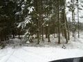
Unlike the last geohash, where the spruce was old, tall and culled so there was no underbrush, this was totally overgrown. Trees every single meter in every direction. And they were snowy! And I had to duck into them. And the sky had grayed over in anticipation of the oncoming blizzard I was going to have to drive through on the way to Katrineholm and Stockholm.
- Totally featureless sky, check
- Trees everywhere so you can't see the forest for all the trees, check
- Snow on everything so everything is white, check
- Losing all sense of direction, check
Of course the tall trees were messing with the GPS again, but not crazy much, but I actually got a bit lost wandering the last 20 meters. I thought I was going east at one point, towards the hash, but I was going west and I noticed it cause I was getting further away from the hash, not closer. Nothing to get scared about, I could always just use my tracks to get back to the car, but it felt crazy loosing your sense of direction so bad since I had no point of reference at all.
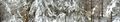
I found the spot about a minute later, and the GPS in the phone was bouncing me around a bit but it stabilized in a very very tiny clearing. See the panoramas how cramped it is. That was like the biggest clearing in the whole patch of forest. Some pics and then back to the car. On the way to the hash I had to jump a creek, and it turned out it was a bit wider than I had thought. I had made the jump with cm to spare so on the way back i found a narrower spot.
Headed back to Max to get lunch and bought a some supplies at Biltema, especially a flashlight so I always can have one in the car. I know it is about to get very dark before 2012-01-26 59 16.
- Deflowered -- Cjk @57.0764,14.0874 08:39, 26 January 2012 (EST)
Photos
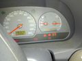
Frozen. -1 C
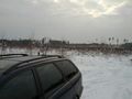
Clear cut
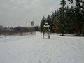
Weirdo contraption.
Into the spruces

Hot Snakes and lost in woods @57.0763,14.0874

Stupid grin
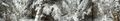
Dense forest!
Way out?
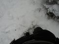
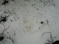
Follow footprints out.
Authentic yellow snow
The creek I jumped
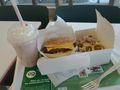
Nutritious lunch, spicy Cheddar grand luxe, luxury strawberry shake, chili cheese fries at Max!


Achievements
Carl-Johan earned the Land geohash achievement
|

Carl-Johan earned the Graticule Unlocked Achievement
|
Carl-Johan earned the Multihash Achievement
|
Carl-Johan achieved level 6 of the Minesweeper Geohash achievement
|
Carl-Johan achieved level 6 of the Minesweeper Geohash achievement
|