Difference between revisions of "2012-01-28 42 -87"
From Geohashing
imported>EvilUncleNomo ([live picture] I'm game. [http://www.openstreetmap.org/?lat=42.51339488&lon=-87.99066242&zoom=16&layers=B000FTF @42.5134,-87.9907]) |
imported>EvilUncleNomo ([live picture] Its out there somewhere [http://www.openstreetmap.org/?lat=42.51454350&lon=-87.99062322&zoom=16&layers=B000FTF @42.5145,-87.9906]) |
||
| Line 30: | Line 30: | ||
Image:2012-01-28_42_-87_15-58-59-208.jpg | I'm game. [http://www.openstreetmap.org/?lat=42.51339488&lon=-87.99066242&zoom=16&layers=B000FTF @42.5134,-87.9907] | Image:2012-01-28_42_-87_15-58-59-208.jpg | I'm game. [http://www.openstreetmap.org/?lat=42.51339488&lon=-87.99066242&zoom=16&layers=B000FTF @42.5134,-87.9907] | ||
| + | |||
| + | Image:2012-01-28_42_-87_16-05-53-574.jpg | Its out there somewhere [http://www.openstreetmap.org/?lat=42.51454350&lon=-87.99062322&zoom=16&layers=B000FTF @42.5145,-87.9906] | ||
</gallery> | </gallery> | ||
Revision as of 22:05, 28 January 2012
| Sat 28 Jan 2012 in 42,-87: 42.5144893, -87.9874734 geohashing.info google osm bing/os kml crox |
Location
A field north of the Illinois/Wisconsin border, west of I-94.
Participants
Plans
- EvilUncleNomo and The Wife are planning on attempting this geohash at Saturday afternoon at 4:00 p.m.. Hopefully, we'll see RocketMac there.
Expedition
Tracklog
Photos
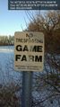
Why do we always find the "No Trespassing" signs? @42.5130,-87.9906
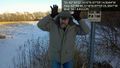
I'm game. @42.5134,-87.9907
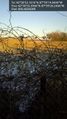
Its out there somewhere @42.5145,-87.9906


Achievements