Difference between revisions of "2012-01-28 42 -87"
imported>EvilUncleNomo ([live picture] The Wife wants to go someplace warm [http://www.openstreetmap.org/?lat=42.51347782&lon=-87.99075837&zoom=16&layers=B000FTF @42.5135,-87.9908]) |
imported>EvilUncleNomo |
||
| Line 16: | Line 16: | ||
== Expedition == | == Expedition == | ||
| − | + | Friday morning when I looked at the geohash for Saturday, I noticed that the target in the [[Kenosha, Wisconsin|Kenosha, Wisconsin]] gradicule was near the Illinois/Wisconsin border so I "talked" to [[User:RocketMac|RocketMac]] about a the possibility of a meetup. He said, "If you were only looking for the meetup, please don't count on me, but I will REALLY try." | |
| − | + | I discussed it with [[User:The Wife|The Wife]] and we decided to go for it. As she put it, "Our choices are an empty field in Illinois or an empty field in Wisconsin." | |
| − | + | ||
| + | We drove over an hour to the site only to discover we were blocked by a "No Trespassing" signs. The closest I was able to get was about 850 feet. We waited around a bit in the hope meeting [[User:RocketMac|RocketMac]] (or any other geohasher), but that goal remained unfulfilled also. Perhaps we'll have better luck next time. | ||
== Photos == | == Photos == | ||
| − | |||
| − | |||
| − | |||
<gallery perrow="5"> | <gallery perrow="5"> | ||
| − | Image:2012-01-28_42_-87_15-58-19-071.jpg | Why do we always find the "No Trespassing" signs? | + | Image:2012-01-28_42_-87_15-58-19-071.jpg | Why do we always find the "No Trespassing" signs? |
| − | Image:2012-01-28_42_-87_15-58-59-208.jpg | I'm game | + | Image:2012-01-28_42_-87_15-58-59-208.jpg | I'm game |
| − | Image:2012-01-28_42_-87_16-05-53-574.jpg | Its out there somewhere | + | Image:2012-01-28_42_-87_16-05-53-574.jpg | Its out there somewhere |
| − | Image:2012-01-28_42_-87_16-10-30-249.jpg | The Wife wants to go someplace warm | + | Image:2012-01-28_42_-87_16-10-30-249.jpg | The Wife wants to go someplace warm |
</gallery> | </gallery> | ||
| Line 41: | Line 39: | ||
| − | |||
| − | |||
| − | |||
| − | |||
[[Category:Expeditions]] | [[Category:Expeditions]] | ||
| − | |||
| − | |||
| − | |||
| − | |||
| − | |||
| − | |||
| − | |||
| − | |||
| − | |||
| − | |||
| − | |||
[[Category:Coordinates not reached]] | [[Category:Coordinates not reached]] | ||
| − | + | [[Category:Not reached - No public access]] | |
| − | |||
| − | [[Category:Not reached - No public access]] | ||
| − | |||
| − | |||
| − | |||
Revision as of 02:40, 29 January 2012
| Sat 28 Jan 2012 in 42,-87: 42.5144893, -87.9874734 geohashing.info google osm bing/os kml crox |
Location
A field north of the Illinois/Wisconsin border, west of I-94.
Participants
Plans
- EvilUncleNomo and The Wife are planning on attempting this geohash at Saturday afternoon at 4:00 p.m.. Hopefully, we'll see RocketMac there.
Expedition
Friday morning when I looked at the geohash for Saturday, I noticed that the target in the Kenosha, Wisconsin gradicule was near the Illinois/Wisconsin border so I "talked" to RocketMac about a the possibility of a meetup. He said, "If you were only looking for the meetup, please don't count on me, but I will REALLY try."
I discussed it with The Wife and we decided to go for it. As she put it, "Our choices are an empty field in Illinois or an empty field in Wisconsin."
We drove over an hour to the site only to discover we were blocked by a "No Trespassing" signs. The closest I was able to get was about 850 feet. We waited around a bit in the hope meeting RocketMac (or any other geohasher), but that goal remained unfulfilled also. Perhaps we'll have better luck next time.
Photos
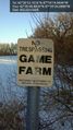
Why do we always find the "No Trespassing" signs?
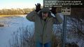
I'm game
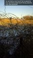
Its out there somewhere
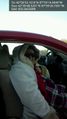
The Wife wants to go someplace warm


