Difference between revisions of "2012-01-29 60 16"
imported>Cjk ([live picture] People coming from the ice) |
imported>FippeBot m (Location) |
||
| (13 intermediate revisions by one other user not shown) | |||
| Line 1: | Line 1: | ||
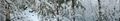
| − | + | [[Image:{{{image|2012-01-29_60_16_12-36-18-693.jpg}}}|thumb|left]] | |
| − | |||
| − | |||
| − | [[Image:{{{image| | ||
| − | |||
| − | |||
| − | |||
| − | |||
| − | |||
| − | |||
{{meetup graticule | {{meetup graticule | ||
| lat=60 | | lat=60 | ||
| Line 19: | Line 10: | ||
== Location == | == Location == | ||
<!-- where you've surveyed the hash to be --> | <!-- where you've surveyed the hash to be --> | ||
| + | Between a private road and the lake Storljusen near Sala. Just 20 meters into the woods. | ||
== Participants == | == Participants == | ||
<!-- who attended --> | <!-- who attended --> | ||
| + | *[[User:Cjk|Carl-Johan]] | ||
== Plans == | == Plans == | ||
<!-- what were the original plans --> | <!-- what were the original plans --> | ||
| + | Since todays latitude was really low, that meant that [[Sandviken, Sweden]] and [[Falun, Sweden]] was reachable to fill up my minesweeper achievement. So the plan was to drive like [https://maps.google.com/maps?saddr=Unknown+road&daddr=59.3322502,18.0190163+to:59.3568681,17.8759693+to:STORLJUSEN+109,+733+99+M%C3%B6klinta,+Sweden+to:60.11199,16.04703+to:59.99535,15.80814+to:Unknown+road+to:Stora+Essingen,+Sweden&hl=en&ie=UTF8&ll=59.949509,16.787109&spn=2.082477,4.42749&sll=60.006539,15.746155&sspn=0.129922,0.276718&geocode=FWJViQMd7_YSAQ%3BFZpWiQMdyPISASl1Wgm6KnZfRjHR_5MjxFC_yw%3BFcS2iQMdAcQQASmFApFDKp5fRjFQjsAY8_4AEw%3BFfi4kwMdAff6ACk9Lm6DBwxeRjGJy_shGyNLhQ%3BFXY8lQMdttv0ACmrDfEpn-VdRjFwDMAY8_4AEw%3BFdZ0kwMdjDbxACmvBy03DsJdRjGQhdIY8_4AEw%3BFSerkwMd0p_rAA%3BFVIqiQMdzn0SASlJL6EROnZfRjEprsNwAWPNsg&oq=stora+&mra=dpe&mrsp=5&sz=12&via=1,2,4,5&t=m&z=8 this]. | ||
| + | |||
| + | *[[2012-01-29 60 16]] | ||
| + | *[[2012-01-29 60 15]] | ||
| + | |||
| + | == Video == | ||
| + | A short video of me having fun on the frozen lake just north of the hash: [http://www.youtube.com/watch?v=-d8P_LOWSMI youtube] | ||
== Expedition == | == Expedition == | ||
<!-- how it all turned out. your narrative goes here. --> | <!-- how it all turned out. your narrative goes here. --> | ||
| + | Got up early since I knew I could do this multihash today. Jumped in the car and drove onto the E18 and then the 70 towards Sala. It was a beautiful day with a totally clear sky. Got close to Sala and took the right road. Crossed the rails and headed onto a snowy tiny road. Saw a sign that they were hunting moose today so they might be scared and run out into the road. Got closer and closer to the lake Storljusen and passed a tiny bed and breakfast. Got right to the lake and there was a suprising amount of people and cars there. I headed into the more private road and parked the car 180 m or so from the hash point since there was a nice place to park there. | ||
| + | |||
| + | I headed in the hash's direction, and walked on the road that follow the train tracks. Took a right into the woods on a path and found where I had to go through the trees. Found the hash and took some pictures and marked the spot with my day-glow paint in the snow. | ||
| + | From the hash I could hear cars racing and snow scooters racing as well. Was it coming from the lake? I got back to the car and drove to the lake again and yes, people were driving on it! Fun! I decided to give it a go. I met a car on the ice and I slowed down and out came a man looking at me so I drove closer and rolled down the window. It was the local beaver conservationist! He told me that there was a beaver lodge near the first island, and that was the most popular island to race around, but it scared the beavers, and you might run over them. So he said to drive on the main part of the lake instead. I said, fine with me and took a nice tour of the lake. | ||
| − | *-3C, sun, powdered snow -- [[User:Cjk| | + | Lots of opposite lock when you get the tail out. Lots of fun! View the video above. |
| + | |||
| + | Then onto [[2012-01-29 60 15]]. | ||
| + | |||
| + | *-3C, sun, powdered snow -- [[User:Cjk|Carl-Johan]] [http://www.openstreetmap.org/?lat=60.01254547&lon=16.44759511&zoom=16&layers=B000FTF @60.0125,16.4476] 06:31, 29 January 2012 (EST) | ||
== Tracklog == | == Tracklog == | ||
<!-- if your GPS device keeps a log, you may post a link here --> | <!-- if your GPS device keeps a log, you may post a link here --> | ||
| Line 39: | Line 47: | ||
--> | --> | ||
<gallery perrow="5"> | <gallery perrow="5"> | ||
| + | |||
| + | Image:2012-01-29_60_16_21-57-29-233.jpg | Moose hunt in progress | ||
| + | |||
| + | Image:2012-01-29_60_16_21-58-03-150.jpg | Good place to park | ||
| + | |||
| + | Image:2012-01-29_60_16_21-58-45-274.jpg | In there somewhere | ||
| + | |||
Image:2012-01-29_60_16_12-36-18-693.jpg | DFA1979 [http://www.openstreetmap.org/?lat=60.01260000&lon=16.44760000&zoom=16&layers=B000FTF @60.0126,16.4476] | Image:2012-01-29_60_16_12-36-18-693.jpg | DFA1979 [http://www.openstreetmap.org/?lat=60.01260000&lon=16.44760000&zoom=16&layers=B000FTF @60.0126,16.4476] | ||
| Line 49: | Line 64: | ||
Image:2012-01-29_60_16_12-40-56-214.jpg | Marked [http://www.openstreetmap.org/?lat=59.99950000&lon=16.42430000&zoom=16&layers=B000FTF @59.9995,16.4243] | Image:2012-01-29_60_16_12-40-56-214.jpg | Marked [http://www.openstreetmap.org/?lat=59.99950000&lon=16.42430000&zoom=16&layers=B000FTF @59.9995,16.4243] | ||
| − | |||
| − | |||
| − | |||
| − | |||
| − | |||
| − | |||
| − | |||
Image:2012-01-29_60_16_21-59-27-807.jpg | The spot | Image:2012-01-29_60_16_21-59-27-807.jpg | The spot | ||
| Line 67: | Line 75: | ||
Image:2012-01-29_60_16_22-03-39-325.jpg | People coming from the ice | Image:2012-01-29_60_16_22-03-39-325.jpg | People coming from the ice | ||
| + | |||
| + | Image:2012-01-29_60_16_22-04-16-838.jpg | It is holding | ||
| + | |||
| + | Image:2012-01-29_60_16_22-04-53-664.jpg | Local beaver protector | ||
| + | |||
| + | Image:2012-01-29_60_16_22-05-38-286.jpg | Local snow scooter guys | ||
</gallery> | </gallery> | ||
| Line 72: | Line 86: | ||
{{#vardefine:ribbonwidth|800px}} | {{#vardefine:ribbonwidth|800px}} | ||
<!-- Add any achievement ribbons you earned below, or remove this section --> | <!-- Add any achievement ribbons you earned below, or remove this section --> | ||
| + | {{land geohash | latitude = 60 | longitude = 16 | date = 2012-01-29 | name = [[User:Cjk|Carl-Johan]] }} | ||
| + | {{Frozen Geohash | latitude = 60 | longitude = 16 | date = 2012-01-29 | name = [[User:Cjk|Carl-Johan]] | temperature = -3°C}} | ||
| + | |||
| + | {{Multihash2 | count = 2 | date = 2012-01-29 | name = [[User:Cjk|Carl-Johan]] }} | ||
| + | {{Police geohash | latitude = 60 | longitude = 16 | date = 2012-01-29 | name = [[User:Cjk|Carl-Johan]] | image = 2012-01-29_60_16_22-04-53-664.jpg | encounter = being told by beaver conservationist not to drive near the beavers lodge on the frozen lake }} | ||
| + | {{Minesweeper geohash | graticule = Västerås, Sweden | ranknumber = 8 | n = true | ne = true | e = true | se = true | s = true | sw = true | w = true | nw = true | name = [[User:Cjk|Carl-Johan]] }} | ||
| + | {{Minesweeper geohash | graticule = Uppsala, Sweden | ranknumber = 7 | n = true | ne = true | e = true | s = true | sw = true | w = true | nw = true | name = [[User:Cjk|Carl-Johan]] }} | ||
<!-- =============== USEFUL CATEGORIES FOLLOW ================ | <!-- =============== USEFUL CATEGORIES FOLLOW ================ | ||
Delete the next line ONLY if you have chosen the appropriate categories below. If you are unsure, don't worry. People will read your report and help you with the classification. --> | Delete the next line ONLY if you have chosen the appropriate categories below. If you are unsure, don't worry. People will read your report and help you with the classification. --> | ||
| − | |||
<!-- Potential categories. Please include all the ones appropriate to your expedition --> | <!-- Potential categories. Please include all the ones appropriate to your expedition --> | ||
| Line 90: | Line 110: | ||
[[Category:Expedition without GPS]] | [[Category:Expedition without GPS]] | ||
--> | --> | ||
| + | |||
| + | [[Category:Expeditions]] | ||
| + | [[Category:Expeditions with photos]] | ||
| + | [[Category:Expeditions with videos]] | ||
<!-- if you reached your coords: | <!-- if you reached your coords: | ||
[[Category:Coordinates reached]] | [[Category:Coordinates reached]] | ||
--> | --> | ||
| + | [[Category:Coordinates reached]] | ||
<!-- or if you failed :( | <!-- or if you failed :( | ||
| Line 103: | Line 128: | ||
[[Category:Not reached - Did not attempt]] when you went to an alternate location, or decided early on to abort the expedition. | [[Category:Not reached - Did not attempt]] when you went to an alternate location, or decided early on to abort the expedition. | ||
--> | --> | ||
| + | {{location|SE|U}} | ||
Latest revision as of 02:14, 13 August 2019

| Sun 29 Jan 2012 in 60,16: 60.0125897, 16.4476091 geohashing.info google osm bing/os kml crox |
Location
Between a private road and the lake Storljusen near Sala. Just 20 meters into the woods.
Participants
Plans
Since todays latitude was really low, that meant that Sandviken, Sweden and Falun, Sweden was reachable to fill up my minesweeper achievement. So the plan was to drive like this.
Video
A short video of me having fun on the frozen lake just north of the hash: youtube
Expedition
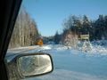
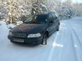
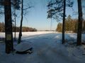
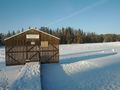
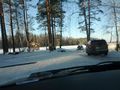
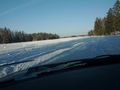
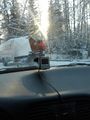
Got up early since I knew I could do this multihash today. Jumped in the car and drove onto the E18 and then the 70 towards Sala. It was a beautiful day with a totally clear sky. Got close to Sala and took the right road. Crossed the rails and headed onto a snowy tiny road. Saw a sign that they were hunting moose today so they might be scared and run out into the road. Got closer and closer to the lake Storljusen and passed a tiny bed and breakfast. Got right to the lake and there was a suprising amount of people and cars there. I headed into the more private road and parked the car 180 m or so from the hash point since there was a nice place to park there.
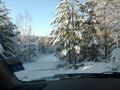
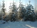
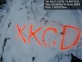
I headed in the hash's direction, and walked on the road that follow the train tracks. Took a right into the woods on a path and found where I had to go through the trees. Found the hash and took some pictures and marked the spot with my day-glow paint in the snow.
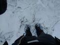
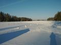
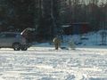
From the hash I could hear cars racing and snow scooters racing as well. Was it coming from the lake? I got back to the car and drove to the lake again and yes, people were driving on it! Fun! I decided to give it a go. I met a car on the ice and I slowed down and out came a man looking at me so I drove closer and rolled down the window. It was the local beaver conservationist! He told me that there was a beaver lodge near the first island, and that was the most popular island to race around, but it scared the beavers, and you might run over them. So he said to drive on the main part of the lake instead. I said, fine with me and took a nice tour of the lake.
Lots of opposite lock when you get the tail out. Lots of fun! View the video above.
Then onto 2012-01-29 60 15.
- -3C, sun, powdered snow -- Carl-Johan @60.0125,16.4476 06:31, 29 January 2012 (EST)
Tracklog
Photos
Moose hunt in progress
Good place to park
In there somewhere

DFA1979 @60.0126,16.4476

Nice day for a hash @60.0126,16.4476
Panorama 1 @60.0126,16.4477
Panorama 2 @60.0126,16.4477
Marked @59.9995,16.4243
The spot
Back at the car
Can you drive out on the lake?
Storljusen boat society, it really is a lake.
Seems like you can drive on it.
People coming from the ice
It is holding
Local beaver protector
Local snow scooter guys


Achievements
Carl-Johan earned the Land geohash achievement
|

Carl-Johan earned the Multihash Achievement
|
Carl-Johan earned the Police Geohash Achievement
|
Carl-Johan completed the Minesweeper Geohash achievement
|
Carl-Johan achieved level 7 of the Minesweeper Geohash achievement
|