Difference between revisions of "2012-02-04 38 -77"
From Geohashing
imported>Jiml m (Adjust result codes) |
imported>FippeBot m (Location) |
||
| Line 57: | Line 57: | ||
[[Category:Expeditions with photos]] | [[Category:Expeditions with photos]] | ||
[[Category:Coordinates reached]] | [[Category:Coordinates reached]] | ||
| + | {{location|US|VA|PW}} | ||
Latest revision as of 02:17, 13 August 2019
| Sat 4 Feb 2012 in 38,-77: 38.8079377, -77.5303929 geohashing.info google osm bing/os kml crox |
Location
Part of Manassas battlefield park, just across a creek from a handy park road.
Park open to the public until dark. I could go again if anyone wants to go on Sunday. I forgot my camera, and had to use my cell phone.
Participants
Plans
Expedition
Unknown. Appears that someone went per the location comments.
Tracklog
http://www.openstreetmap.org/user/SDGathman/traces/1176133
Photos
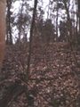
The meetup location on a wooded hillside
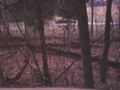
Across a creek from the park road.


Achievements
- Land geohash?