Difference between revisions of "2012-02-05 33 -117"
imported>Scerruti m (→Participants) |
imported>FippeBot m (Location) |
||
| (6 intermediate revisions by 2 users not shown) | |||
| Line 1: | Line 1: | ||
| − | |||
| − | |||
| − | |||
| − | |||
| − | |||
| − | |||
| − | |||
| − | |||
| − | |||
| − | |||
{{meetup graticule | {{meetup graticule | ||
| lat=33 | | lat=33 | ||
| Line 15: | Line 5: | ||
}} | }} | ||
| − | + | ||
__NOTOC__ | __NOTOC__ | ||
== Location == | == Location == | ||
| − | + | ||
This hash is located in a field at the corner of Mount Israel and Detwiler Roads adjacent to the Elfin Forest Recreational Reserve and near Lake Hodges in Escondido, CA. The area is for the most part private homes many with horses. | This hash is located in a field at the corner of Mount Israel and Detwiler Roads adjacent to the Elfin Forest Recreational Reserve and near Lake Hodges in Escondido, CA. The area is for the most part private homes many with horses. | ||
== Participants == | == Participants == | ||
| − | + | ||
| − | [[user:scerruti|scerruti]] and his son A' (son D* waited in the car 100m from the hash so he gets partial credit). | + | * [[user:scerruti|scerruti]] and his son A' (son D* waited in the car 100m from the hash so he gets partial credit). |
== Plans == | == Plans == | ||
| − | + | ||
Each month my sons and I have a camping trip with our Indian Guides group, the Redhawk Nation. I make a point of checking the hashes for the weekend in case one falls close to our route or near our camp. This weekend Friday's hash fell on our route and Sunday's hash fell just a little off our return route in an area I like to visit. My plans on Sunday were to leave camp, grab a bite to eat (somewhere with a patio because we smell of smoke and a weekend without showers) and then detour to the hash on the way home. | Each month my sons and I have a camping trip with our Indian Guides group, the Redhawk Nation. I make a point of checking the hashes for the weekend in case one falls close to our route or near our camp. This weekend Friday's hash fell on our route and Sunday's hash fell just a little off our return route in an area I like to visit. My plans on Sunday were to leave camp, grab a bite to eat (somewhere with a patio because we smell of smoke and a weekend without showers) and then detour to the hash on the way home. | ||
| Line 35: | Line 25: | ||
We diverted off the I-15 following the navigation directions provided by Google Maps and it took us right to the location. I was fairly concerned we would not be able to access the hash because all the lots were fenced. As we turned the corner to Detwiler I was pleased to note that the gate to the lot was hanging open and well trafficked. I did have to drive up the road to turn around, but I was able to park in front of the lot. | We diverted off the I-15 following the navigation directions provided by Google Maps and it took us right to the location. I was fairly concerned we would not be able to access the hash because all the lots were fenced. As we turned the corner to Detwiler I was pleased to note that the gate to the lot was hanging open and well trafficked. I did have to drive up the road to turn around, but I was able to park in front of the lot. | ||
| − | Only one of my sons, my favorite, decided to accompany me to the hash point. To be honest he may have somehow come to the belief that there might be candy at the hash point. In my defense, since it was a beautiful day and it was a hash point there may indeed have been candy there. It took a little effort to find the exact point because we lost data turning onto Detwiler and because my phone went to sleep and then had to get a new GPS fix | + | Only one of my sons, my favorite, decided to accompany me to the hash point. To be honest he may have somehow come to the belief that there might be candy at the hash point. In my defense, since it was a beautiful day and it was a hash point there may indeed have been candy there. It took a little effort to find the exact point because we lost data turning onto Detwiler and because my phone went to sleep and then had to get a new GPS fix. |
I did decide I was at the point and snapped a few pictures. Then I realized I couldn't upload them there. I only realize a few yards away that I might not have location turned on for my camera, so I captured another shot from that location. I also captured a shot of the fence. | I did decide I was at the point and snapped a few pictures. Then I realized I couldn't upload them there. I only realize a few yards away that I might not have location turned on for my camera, so I captured another shot from that location. I also captured a shot of the fence. | ||
| − | + | == Photos == | |
| − | |||
| − | |||
| − | == Photos == | ||
| − | |||
| − | |||
| − | |||
| − | |||
| + | <gallery> | ||
Image:2012-02-05_33_-117_14-51-00-835.jpg | Beautiful spot near Elfin Forest Recreational Reserve [http://www.openstreetmap.org/?lat=33.05930000&lon=-117.13800000&zoom=16&layers=B000FTF @33.0593,-117.1380] | Image:2012-02-05_33_-117_14-51-00-835.jpg | Beautiful spot near Elfin Forest Recreational Reserve [http://www.openstreetmap.org/?lat=33.05930000&lon=-117.13800000&zoom=16&layers=B000FTF @33.0593,-117.1380] | ||
Image:2012-02-05_33_-117_14-51-44-675.jpg | Open fence to lot where hash was located [http://www.openstreetmap.org/?lat=33.05980000&lon=-117.13800000&zoom=16&layers=B000FTF @33.0598,-117.1380] | Image:2012-02-05_33_-117_14-51-44-675.jpg | Open fence to lot where hash was located [http://www.openstreetmap.org/?lat=33.05980000&lon=-117.13800000&zoom=16&layers=B000FTF @33.0598,-117.1380] | ||
| + | |||
| + | Image:2012-02-05_33_-117_09-16-18-734.jpg | A' and I at the hash point. He looks smaller because he is farther from the camera. | ||
| + | |||
| + | Image:2012-02-05_33_-117_09-20-29-202.jpg | This is the actual spot of the hash point. If I was smart enough to tag this picture with the location you could figure that out for yourself. | ||
</gallery> | </gallery> | ||
== Achievements == | == Achievements == | ||
{{#vardefine:ribbonwidth|800px}} | {{#vardefine:ribbonwidth|800px}} | ||
| − | + | ||
{{land geohash | {{land geohash | ||
| Line 62: | Line 50: | ||
| date = 2012-02-05 | | date = 2012-02-05 | ||
| name = scerruti | | name = scerruti | ||
| − | | image = | + | | image = 2012-02-05_33_-117_09-16-18-734.jpg |
}} | }} | ||
| − | |||
| − | |||
| − | |||
| − | |||
| − | |||
| − | |||
| − | |||
| − | |||
| − | |||
| − | |||
[[Category:Expeditions]] | [[Category:Expeditions]] | ||
[[Category:Expeditions with photos]] | [[Category:Expeditions with photos]] | ||
| − | + | ||
[[Category:Coordinates reached]] | [[Category:Coordinates reached]] | ||
| − | + | {{location|US|CA|SD}} | |
| − | |||
| − | |||
| − | |||
| − | |||
| − | |||
| − | |||
| − | |||
| − | |||
Latest revision as of 02:18, 13 August 2019
| Sun 5 Feb 2012 in 33,-117: 33.0592770, -117.1379030 geohashing.info google osm bing/os kml crox |
Location
This hash is located in a field at the corner of Mount Israel and Detwiler Roads adjacent to the Elfin Forest Recreational Reserve and near Lake Hodges in Escondido, CA. The area is for the most part private homes many with horses.
Participants
- scerruti and his son A' (son D* waited in the car 100m from the hash so he gets partial credit).
Plans
Each month my sons and I have a camping trip with our Indian Guides group, the Redhawk Nation. I make a point of checking the hashes for the weekend in case one falls close to our route or near our camp. This weekend Friday's hash fell on our route and Sunday's hash fell just a little off our return route in an area I like to visit. My plans on Sunday were to leave camp, grab a bite to eat (somewhere with a patio because we smell of smoke and a weekend without showers) and then detour to the hash on the way home.
Expedition
After our Star Wars Bear Claw event and Zocolo we headed towards home. Of course the nearly dead battery in my minivan required some assistance from my backup battery I carry and I had to stop at the Golden Acorn Casino for a little air in one of my tires. Using my trusty Galaxy Nexus that also provides me with Geohash information I located a Sonic along our route where we could order and eat outside, sparing the other diners the favor of our aroma. Fortune smiled on me as there was also a drive thru Starbucks on our way back to the Interstate (the boys got free ice cream at Sonic instead of Wacky Pack toys).
We diverted off the I-15 following the navigation directions provided by Google Maps and it took us right to the location. I was fairly concerned we would not be able to access the hash because all the lots were fenced. As we turned the corner to Detwiler I was pleased to note that the gate to the lot was hanging open and well trafficked. I did have to drive up the road to turn around, but I was able to park in front of the lot.
Only one of my sons, my favorite, decided to accompany me to the hash point. To be honest he may have somehow come to the belief that there might be candy at the hash point. In my defense, since it was a beautiful day and it was a hash point there may indeed have been candy there. It took a little effort to find the exact point because we lost data turning onto Detwiler and because my phone went to sleep and then had to get a new GPS fix.
I did decide I was at the point and snapped a few pictures. Then I realized I couldn't upload them there. I only realize a few yards away that I might not have location turned on for my camera, so I captured another shot from that location. I also captured a shot of the fence.
Photos
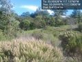
Beautiful spot near Elfin Forest Recreational Reserve @33.0593,-117.1380
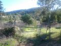
Open fence to lot where hash was located @33.0598,-117.1380

A' and I at the hash point. He looks smaller because he is farther from the camera.
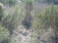
This is the actual spot of the hash point. If I was smart enough to tag this picture with the location you could figure that out for yourself.


Achievements
scerruti earned the Land geohash achievement
|