Difference between revisions of "2012-02-08 33 -117"
From Geohashing
imported>Scerruti ([live] Nothing to see here, move along.) |
imported>FippeBot m (Location) |
||
| (9 intermediate revisions by 2 users not shown) | |||
| Line 1: | Line 1: | ||
| − | |||
| − | |||
| − | |||
| − | |||
| − | |||
| − | |||
| − | |||
| − | |||
{{meetup graticule | {{meetup graticule | ||
| lat=33 | | lat=33 | ||
| Line 14: | Line 6: | ||
}} | }} | ||
| − | + | ||
__NOTOC__ | __NOTOC__ | ||
== Location == | == Location == | ||
| − | + | ||
In a driveway in Encinitas near my son's school. | In a driveway in Encinitas near my son's school. | ||
== Participants == | == Participants == | ||
| − | + | ||
* [[user:scerruti|scerruti]] | * [[user:scerruti|scerruti]] | ||
| Line 33: | Line 25: | ||
*Nothing to see here, move along. -- [[User:Scerruti|Scerruti]] [http://www.openstreetmap.org/?lat=33.04268070&lon=-117.26960130&zoom=16&layers=B000FTF @33.0427,-117.2696] 08:29, 08 February 2012 (PST) | *Nothing to see here, move along. -- [[User:Scerruti|Scerruti]] [http://www.openstreetmap.org/?lat=33.04268070&lon=-117.26960130&zoom=16&layers=B000FTF @33.0427,-117.2696] 08:29, 08 February 2012 (PST) | ||
| − | + | ||
| − | + | Yep, dropped A' off at school. Went to the hashpoint 3.8 km away. I did pass an accident with an attending police officer on the way, but it didn't rise to the level of a Police Geohash. One thing I noticed is that my camera is having issues with geotagging photos accurately so I removed one photo with an inaccurate infobox. I stand by the photos themselves as evidence of my presence. | |
== Photos == | == Photos == | ||
| − | + | ||
| − | + | ||
| − | |||
<gallery perrow="5"> | <gallery perrow="5"> | ||
| + | |||
| + | Image:2012-02-08_33_-117_08-31-01-859.jpg | Remember to smile. [http://www.openstreetmap.org/?lat=33.04250000&lon=-117.27000000&zoom=16&layers=B000FTF @33.0425,-117.2700] | ||
| + | |||
| + | Image:2012-02-08_33_-117_08-31-39-322.jpg | The lovely house at the hashpoint. | ||
| + | |||
| + | Image:2012-02-08_33_-117_08-32-13-295.jpg | The street sign at the corner. | ||
</gallery> | </gallery> | ||
== Achievements == | == Achievements == | ||
{{#vardefine:ribbonwidth|800px}} | {{#vardefine:ribbonwidth|800px}} | ||
| − | |||
| + | {{land geohash | ||
| − | + | | latitude = 33 | |
| − | + | | longitude = -117 | |
| − | + | | date = 2012-02-08 | |
| + | | name = scerruti | ||
| + | | image = 2012-02-08_33_-117_08-31-01-859.jpg | ||
| + | |||
| + | }} | ||
| − | |||
| − | |||
| − | |||
| − | |||
| − | |||
[[Category:Expeditions]] | [[Category:Expeditions]] | ||
| − | + | ||
[[Category:Expeditions with photos]] | [[Category:Expeditions with photos]] | ||
| − | + | ||
| − | |||
| − | |||
| − | |||
[[Category:Coordinates reached]] | [[Category:Coordinates reached]] | ||
| − | + | {{location|US|CA|SD}} | |
| − | |||
| − | |||
| − | |||
| − | |||
| − | |||
| − | |||
| − | |||
| − | |||
| − | |||
Latest revision as of 02:20, 13 August 2019
| Wed 8 Feb 2012 in 33,-117: 33.0425578, -117.2696880 geohashing.info google osm bing/os kml crox |
Location
In a driveway in Encinitas near my son's school.
Participants
Plans
- I may hit this hashpoint before I get coffee. -- Scerruti 06:55, 08 February 2012 (PST)
Expedition
- Nothing to see here, move along. -- Scerruti @33.0427,-117.2696 08:29, 08 February 2012 (PST)
Yep, dropped A' off at school. Went to the hashpoint 3.8 km away. I did pass an accident with an attending police officer on the way, but it didn't rise to the level of a Police Geohash. One thing I noticed is that my camera is having issues with geotagging photos accurately so I removed one photo with an inaccurate infobox. I stand by the photos themselves as evidence of my presence.
Photos

Remember to smile. @33.0425,-117.2700
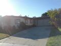
The lovely house at the hashpoint.
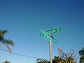
The street sign at the corner.


Achievements
scerruti earned the Land geohash achievement
|