Difference between revisions of "2012-02-13 50 10"
From Geohashing
imported>Mampfred (Created page with "{{subst:Expedition |lat = 50 |lon = 10 |date = 2012-02-13 }}") |
imported>Mampfred (report done) |
||
| Line 1: | Line 1: | ||
| − | |||
| − | |||
| − | |||
| − | |||
| − | |||
| − | |||
| − | |||
| − | |||
| − | |||
| − | |||
{{meetup graticule | {{meetup graticule | ||
| lat=50 | | lat=50 | ||
| Line 15: | Line 5: | ||
}} | }} | ||
| − | |||
__NOTOC__ | __NOTOC__ | ||
== Location == | == Location == | ||
| − | + | On a field near Gotha - or Tüttleben to be precise. | |
== Participants == | == Participants == | ||
| − | + | * [[User:Rincewind|Rincewind]] | |
| + | * [[User:Mampfred|Mampfred]] | ||
== Plans == | == Plans == | ||
| − | + | Go there after work, the usual except there's a little competition of darts in our way, so it's gonna be quite late. | |
== Expedition == | == Expedition == | ||
| − | + | The darts competition was canceled but we still got a late start. We met at 9pm and drove to the hash for about 20 minutes. The hash was on a snow covered field next to a brightly lit road. So bright in fact that we didn't even need to unpack our torches this time. Easy hash if there ever was one. We were back home around 10pm. | |
== Tracklog == | == Tracklog == | ||
| − | + | See [http://www.everytrail.com/view_trip.php?trip_id=1451098 here]. | |
== Photos == | == Photos == | ||
| − | |||
| − | |||
| − | |||
<gallery perrow="5"> | <gallery perrow="5"> | ||
| + | Image:2012-02-13_50_10_coordinates.jpg | Coordinates ... | ||
| + | Image:2012-02-13_50_10_reached.jpg | ... reached. | ||
| + | Image:2012-02-13_50_10_hashgrin.jpg | Hashgrin | ||
</gallery> | </gallery> | ||
== Achievements == | == Achievements == | ||
{{#vardefine:ribbonwidth|800px}} | {{#vardefine:ribbonwidth|800px}} | ||
| − | + | * Land | |
| − | |||
| − | |||
| − | |||
| − | |||
| − | |||
| − | |||
| − | |||
| − | |||
| − | |||
| − | |||
| − | |||
[[Category:Expeditions]] | [[Category:Expeditions]] | ||
| − | |||
[[Category:Expeditions with photos]] | [[Category:Expeditions with photos]] | ||
| − | |||
| − | |||
| − | |||
| − | |||
| − | |||
[[Category:Coordinates reached]] | [[Category:Coordinates reached]] | ||
| − | |||
| − | |||
| − | |||
| − | |||
| − | |||
| − | |||
| − | |||
| − | |||
| − | |||
| − | |||
Revision as of 18:53, 15 February 2012
| Mon 13 Feb 2012 in 50,10: 50.9428011, 10.7956477 geohashing.info google osm bing/os kml crox |
Location
On a field near Gotha - or Tüttleben to be precise.
Participants
Plans
Go there after work, the usual except there's a little competition of darts in our way, so it's gonna be quite late.
Expedition
The darts competition was canceled but we still got a late start. We met at 9pm and drove to the hash for about 20 minutes. The hash was on a snow covered field next to a brightly lit road. So bright in fact that we didn't even need to unpack our torches this time. Easy hash if there ever was one. We were back home around 10pm.
Tracklog
See here.
Photos
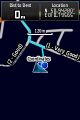
Coordinates ...
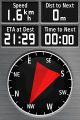
... reached.
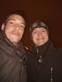
Hashgrin


Achievements
- Land