Difference between revisions of "2012-02-20 59 17"
imported>Cjk ([live] Bro Hof castle looks nice) |
imported>FippeBot m (Location) |
||
| (6 intermediate revisions by one other user not shown) | |||
| Line 1: | Line 1: | ||
| + | [[Image:{{{image|2012-02-20_59_17_16-51-15-490.jpg}}}|thumb|left]] | ||
| − | |||
| − | |||
| − | |||
| − | |||
| − | |||
| − | |||
| − | |||
| − | |||
| − | |||
{{meetup graticule | {{meetup graticule | ||
| lat=59 | | lat=59 | ||
| Line 19: | Line 11: | ||
== Location == | == Location == | ||
<!-- where you've surveyed the hash to be --> | <!-- where you've surveyed the hash to be --> | ||
| + | Right by the road leading up to Bro Hof Castle, which now seems to be a golf course. | ||
== Participants == | == Participants == | ||
<!-- who attended --> | <!-- who attended --> | ||
| + | *[[User:Cjk|Carl-Johan]] | ||
== Plans == | == Plans == | ||
<!-- what were the original plans --> | <!-- what were the original plans --> | ||
| + | Was meeting TheDoctor in town at an artists place and we were going to check the surroundings of Slussen to make an art project there. The hash was just 1.8 km south of the commuter train stop Bro so I was planning to go there after the meetings. | ||
== Expedition == | == Expedition == | ||
<!-- how it all turned out. your narrative goes here. --> | <!-- how it all turned out. your narrative goes here. --> | ||
| + | Once we were done planning and scouting out Slussen my boss and I went and bought some tea at the Tea Center on Hornsgatan. We took of south to Södra Station and I bought a poster while TheDoctor was making a phone call. As we approached the platform I realized I had missed my train going towards Bålsta with just 3 min, so I had to wait 27 min. TheDoctor headed south with the train home to his place. Eventually the train came and I slumbered a bit on the 37 min ride to Bro. | ||
| + | Got off and by now it was 16:45 so the sun was setting behind the clouds. First thing I see was a car that had crashed into a light pole. | ||
| − | *Bro Hof castle looks nice -- [[User:Cjk| | + | [[Image:2012-02-20_59_17_16-51-15-490.jpg|200px]] |
| − | + | ||
| − | + | Not how to drive your car. But I was walking on foot. At the first intersection I saw that someone had thrown a bike in the snow a while back. It looked intact so I borrowed it. I could understand why someone had thrown it away. It had nothing on the handlebars and it was locked in 3rd gear so very tough up the hill to Bro Church. As I got onto the road to Bro Hof Castle the road got covered in first snow and then pure ice. All of a sudden the bike just flew underneath me but my cat like reflexes kept me from getting hurt. I started biking on the parts that had snow on them, not the parts with pure ice. | |
| + | |||
| + | I got to a down hill section of the road and I could see that it was pure ice so I ditched the bike for now. I would not be able to bike back up. Walked the rest of the way. This castle has a golf course around it on google maps but it was all snow covered now. The road was really slippery since we had rain a few days ago but now it was -2C so it had all frozen to pure ice. | ||
| + | |||
| + | Found the hash just a few meters off the road. | ||
| + | |||
| + | *Bro Hof castle looks nice -- [[User:Cjk|Carl-Johan]] [http://www.openstreetmap.org/?lat=59.49815977&lon=17.62669737&zoom=16&layers=B000FTF @59.4982,17.6267] 17:06, 20 February 2012 (CET) | ||
| + | |||
| + | Snapped some pics and stamped a big marker in the snow. The battery in the phone was only 3% left so nothing fancy as track logs or anything like that. Walked back up the hill to the bike, rode it back to the train stop and up the borrowed bike in a bike stand. Better there than in a ditch I think. Then a 20 min wait for the train that took me to Karlberg and a walk home from there. | ||
== Photos == | == Photos == | ||
| Line 41: | Line 46: | ||
Image:2012-02-20_59_17_16-51-15-490.jpg | You're doing it wrong! [http://www.openstreetmap.org/?lat=59.51070000&lon=17.63400000&zoom=16&layers=B000FTF @59.5107,17.6340] | Image:2012-02-20_59_17_16-51-15-490.jpg | You're doing it wrong! [http://www.openstreetmap.org/?lat=59.51070000&lon=17.63400000&zoom=16&layers=B000FTF @59.5107,17.6340] | ||
| + | |||
| + | Image:2012-02-20_59_17_17-10-38-789.jpg | [http://www.openstreetmap.org/?lat=59.49810000&lon=17.62670000&zoom=16&layers=B000FTF @59.4981,17.6267] | ||
| + | |||
| + | Image:2012-02-20_59_17_18-51-39-803.jpg | Panorama 1 | ||
| + | |||
| + | Image:2012-02-20_59_17_18-52-00-299.jpg | Panorama 2 | ||
| + | |||
| + | Image:2012-02-20_59_17_18-52-19-748.jpg | Marker | ||
</gallery> | </gallery> | ||
| Line 46: | Line 59: | ||
{{#vardefine:ribbonwidth|800px}} | {{#vardefine:ribbonwidth|800px}} | ||
<!-- Add any achievement ribbons you earned below, or remove this section --> | <!-- Add any achievement ribbons you earned below, or remove this section --> | ||
| + | {{land geohash | latitude = 59 | longitude = 17 | date = 2012-02-20 | name = [[User:Cjk|Carl-Johan]] }} | ||
| + | {{Frozen Geohash | latitude = 59 | longitude = 17 | date = 2012-02-20 | name = [[User:Cjk|Carl-Johan]] | temperature = -2°C }} | ||
| + | {{Public transport geohash | latitude = 59 | longitude = 17 | date = 2012-02-20 | name = [[User:Cjk|Carl-Johan]] }} | ||
<!-- =============== USEFUL CATEGORIES FOLLOW ================ | <!-- =============== USEFUL CATEGORIES FOLLOW ================ | ||
Delete the next line ONLY if you have chosen the appropriate categories below. If you are unsure, don't worry. People will read your report and help you with the classification. --> | Delete the next line ONLY if you have chosen the appropriate categories below. If you are unsure, don't worry. People will read your report and help you with the classification. --> | ||
| − | |||
| − | + | [[Category:Expeditions]] | |
| − | |||
| − | [[Category: | ||
| − | |||
| − | |||
| − | |||
| − | |||
[[Category:Expeditions with photos]] | [[Category:Expeditions with photos]] | ||
| − | + | ||
| − | |||
| − | |||
| − | |||
| − | |||
[[Category:Coordinates reached]] | [[Category:Coordinates reached]] | ||
| − | + | {{location|SE|AB}} | |
| − | |||
| − | |||
| − | |||
| − | |||
| − | |||
| − | |||
| − | |||
| − | |||
| − | |||
Latest revision as of 02:27, 13 August 2019
| Mon 20 Feb 2012 in 59,17: 59.4981044, 17.6267383 geohashing.info google osm bing/os kml crox |
Location
Right by the road leading up to Bro Hof Castle, which now seems to be a golf course.
Participants
Plans
Was meeting TheDoctor in town at an artists place and we were going to check the surroundings of Slussen to make an art project there. The hash was just 1.8 km south of the commuter train stop Bro so I was planning to go there after the meetings.
Expedition
Once we were done planning and scouting out Slussen my boss and I went and bought some tea at the Tea Center on Hornsgatan. We took of south to Södra Station and I bought a poster while TheDoctor was making a phone call. As we approached the platform I realized I had missed my train going towards Bålsta with just 3 min, so I had to wait 27 min. TheDoctor headed south with the train home to his place. Eventually the train came and I slumbered a bit on the 37 min ride to Bro.
Got off and by now it was 16:45 so the sun was setting behind the clouds. First thing I see was a car that had crashed into a light pole.

Not how to drive your car. But I was walking on foot. At the first intersection I saw that someone had thrown a bike in the snow a while back. It looked intact so I borrowed it. I could understand why someone had thrown it away. It had nothing on the handlebars and it was locked in 3rd gear so very tough up the hill to Bro Church. As I got onto the road to Bro Hof Castle the road got covered in first snow and then pure ice. All of a sudden the bike just flew underneath me but my cat like reflexes kept me from getting hurt. I started biking on the parts that had snow on them, not the parts with pure ice.
I got to a down hill section of the road and I could see that it was pure ice so I ditched the bike for now. I would not be able to bike back up. Walked the rest of the way. This castle has a golf course around it on google maps but it was all snow covered now. The road was really slippery since we had rain a few days ago but now it was -2C so it had all frozen to pure ice.
Found the hash just a few meters off the road.
- Bro Hof castle looks nice -- Carl-Johan @59.4982,17.6267 17:06, 20 February 2012 (CET)
Snapped some pics and stamped a big marker in the snow. The battery in the phone was only 3% left so nothing fancy as track logs or anything like that. Walked back up the hill to the bike, rode it back to the train stop and up the borrowed bike in a bike stand. Better there than in a ditch I think. Then a 20 min wait for the train that took me to Karlberg and a walk home from there.
Photos
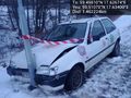
You're doing it wrong! @59.5107,17.6340
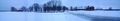
Panorama 1
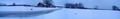
Panorama 2
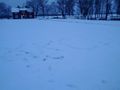
Marker


Achievements
Carl-Johan earned the Land geohash achievement
|

Carl-Johan earned the Public transport geohash achievement
|