Difference between revisions of "2012-02-24 60 15"
From Geohashing
imported>Fasanen ([live picture] Going home. Tracks sent from heaven! [http://www.openstreetmap.org/?lat=60.78465751&lon=15.36386570&zoom=16&layers=B000FTF @60.7847,15.3639]) |
imported>FippeBot m (Location) |
||
| (3 intermediate revisions by 2 users not shown) | |||
| Line 1: | Line 1: | ||
| − | |||
<!-- If you did not specify these parameters in the template, please substitute appropriate values for IMAGE, LAT, LON, and DATE (YYYY-MM-DD format) | <!-- If you did not specify these parameters in the template, please substitute appropriate values for IMAGE, LAT, LON, and DATE (YYYY-MM-DD format) | ||
| Line 19: | Line 18: | ||
== Location == | == Location == | ||
<!-- where you've surveyed the hash to be --> | <!-- where you've surveyed the hash to be --> | ||
| + | Somewhere in the waist deep snow. | ||
== Participants == | == Participants == | ||
<!-- who attended --> | <!-- who attended --> | ||
| + | [[User:Fasanen|Fasanen]] | ||
== Plans == | == Plans == | ||
| Line 43: | Line 44: | ||
Image:2012-02-24_60_15_11-49-57-328.jpg | Going home. Tracks sent from heaven! [http://www.openstreetmap.org/?lat=60.78465751&lon=15.36386570&zoom=16&layers=B000FTF @60.7847,15.3639] | Image:2012-02-24_60_15_11-49-57-328.jpg | Going home. Tracks sent from heaven! [http://www.openstreetmap.org/?lat=60.78465751&lon=15.36386570&zoom=16&layers=B000FTF @60.7847,15.3639] | ||
| + | |||
| + | Image:2012-02-24_60_15_12-15-06-794.jpg | Closest hash neighbour. [http://www.openstreetmap.org/?lat=60.78231896&lon=15.37276061&zoom=16&layers=B000FTF @60.7823,15.3728] | ||
</gallery> | </gallery> | ||
| Line 52: | Line 55: | ||
<!-- =============== USEFUL CATEGORIES FOLLOW ================ | <!-- =============== USEFUL CATEGORIES FOLLOW ================ | ||
Delete the next line ONLY if you have chosen the appropriate categories below. If you are unsure, don't worry. People will read your report and help you with the classification. --> | Delete the next line ONLY if you have chosen the appropriate categories below. If you are unsure, don't worry. People will read your report and help you with the classification. --> | ||
| − | |||
| − | |||
| − | |||
| − | |||
| − | |||
| − | |||
| − | |||
| − | |||
[[Category:Expeditions]] | [[Category:Expeditions]] | ||
| − | |||
[[Category:Expeditions with photos]] | [[Category:Expeditions with photos]] | ||
| − | |||
| − | |||
| − | |||
| − | |||
| − | |||
[[Category:Coordinates reached]] | [[Category:Coordinates reached]] | ||
| − | + | {{location|SE|W}} | |
| − | |||
| − | |||
| − | |||
| − | |||
| − | |||
| − | |||
| − | |||
| − | |||
| − | |||
Latest revision as of 02:31, 13 August 2019
| Fri 24 Feb 2012 in 60,15: 60.7847781, 15.3631585 geohashing.info google osm bing/os kml crox |
Location
Somewhere in the waist deep snow.
Participants
Plans
Expedition
Tracklog
Photos
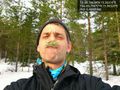
Grew a beard by the time it took to get here. Phew! @60.7847,15.3632
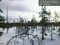
Snow is waist deep. Where are your snow shoes when need them?! @60.7848,15.3631
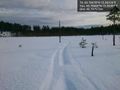
Going home. Tracks sent from heaven! @60.7847,15.3639
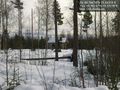
Closest hash neighbour. @60.7823,15.3728


