Difference between revisions of "2012-02-26 56 13"
From Geohashing
imported>Llavids |
imported>FippeBot m (Location) |
||
| Line 39: | Line 39: | ||
[[Category:Meetup on 2012-02-26]] | [[Category:Meetup on 2012-02-26]] | ||
[[Category:Sweden]] | [[Category:Sweden]] | ||
| + | {{location|SE|M}} | ||
Latest revision as of 02:33, 13 August 2019
| Sun 26 Feb 2012 in 56,13: 56.0000466, 13.4837187 geohashing.info google osm bing/os kml crox |
Location
Outside Norra Rörum, Höör, Skåne, Sweden.
Participants
Plans
Drive out and visit geohash while placing a geocache nearby where a US airplane crashed during WW II.
Expedition
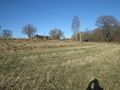
Drove out and had an easy access in a field. If I stepped 3 meters south I would be in graticule 55 13, so it was a close border geohash. Took some photos and then continued to the crash site for placing a geocache there.
Photos
Proof
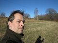
The grin
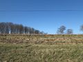
West
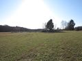
South
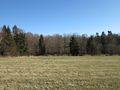
East
North


Achievements
Llavids earned the Land geohash achievement
|
Llavids earned the Consecutive geohash achievement
|