Difference between revisions of "2012-02-28 59 17"
imported>Cjk ([live picture] Dark panorama [http://www.openstreetmap.org/?lat=59.28711853&lon=17.80243504&zoom=16&layers=B000FTF @59.2871,17.8024]) |
imported>FippeBot m (Location) |
||
| (5 intermediate revisions by one other user not shown) | |||
| Line 1: | Line 1: | ||
| − | + | [[Image:{{{image|2012-02-28_59_17_17-58-55-849.jpg}}}|thumb|left]] | |
| − | |||
| − | |||
| − | [[Image:{{{image| | ||
| − | |||
| − | |||
| − | |||
| − | |||
| − | |||
| − | |||
{{meetup graticule | {{meetup graticule | ||
| lat=59 | | lat=59 | ||
| Line 19: | Line 10: | ||
== Location == | == Location == | ||
<!-- where you've surveyed the hash to be --> | <!-- where you've surveyed the hash to be --> | ||
| + | In the common backyard of 4 houses on Ekerö. | ||
== Participants == | == Participants == | ||
<!-- who attended --> | <!-- who attended --> | ||
| + | *[[User:Cjk|Carl-Johan]] | ||
== Plans == | == Plans == | ||
<!-- what were the original plans --> | <!-- what were the original plans --> | ||
| + | Pop off via subway and bus around 1700 when I was done coding for the day. | ||
== Expedition == | == Expedition == | ||
<!-- how it all turned out. your narrative goes here. --> | <!-- how it all turned out. your narrative goes here. --> | ||
| + | Took the Subway to Brommaplan, caught the 302 bus towards Ekerö. Got off at Ekvägen. The sun was setting. Walked around some churchy thing and saw the Moon and Jupiter and Venus in the sky. Snapped a pic and walked towards the houses I had scouted it would be in. Saw a mast for ham radio I think, a HF 3 beam Yagi. Got to the garages of this area and walked in among them. The hash was in the common backyard of 4 houses. I couldn't tell which house to ask permission from cause there was no fences or anything defining the yards, so I just walked the 10 m to the hash at took some pics and left. Walked back to the bus-stop and just missed one. Had to wait a bit. | ||
| + | |||
| + | *Waiting for the bus back home, here it comes. -- [[User:Cjk|Carl-Johan]] [http://www.openstreetmap.org/?lat=59.28713341&lon=17.80244493&zoom=16&layers=B000FTF @59.2871,17.8024] 18:10, 28 February 2012 (CET) | ||
| + | |||
| + | Got on the bus and subway and headed home for a fairly easy hash. | ||
== Tracklog == | == Tracklog == | ||
<!-- if your GPS device keeps a log, you may post a link here --> | <!-- if your GPS device keeps a log, you may post a link here --> | ||
| + | [http://maps.google.com/maps/ms?msa=0&msid=209560846421673743077.0004ba09ee980ac04ebd9 map] | ||
== Photos == | == Photos == | ||
| Line 37: | Line 37: | ||
--> | --> | ||
<gallery perrow="5"> | <gallery perrow="5"> | ||
| − | |||
| − | |||
Image:2012-02-28_59_17_18-00-40-636.jpg | Setting sun [http://www.openstreetmap.org/?lat=59.28680000&lon=17.80250000&zoom=16&layers=B000FTF @59.2868,17.8025] | Image:2012-02-28_59_17_18-00-40-636.jpg | Setting sun [http://www.openstreetmap.org/?lat=59.28680000&lon=17.80250000&zoom=16&layers=B000FTF @59.2868,17.8025] | ||
| Line 45: | Line 43: | ||
Image:2012-02-28_59_17_18-08-00-746.jpg | Ham radio antennas [http://www.openstreetmap.org/?lat=59.28480000&lon=17.80400000&zoom=16&layers=B000FTF @59.2848,17.8040] | Image:2012-02-28_59_17_18-08-00-746.jpg | Ham radio antennas [http://www.openstreetmap.org/?lat=59.28480000&lon=17.80400000&zoom=16&layers=B000FTF @59.2848,17.8040] | ||
| + | |||
| + | Image:2012-02-28_59_17_17-58-55-849.jpg | Hmm [http://www.openstreetmap.org/?lat=59.28380000&lon=17.80200000&zoom=16&layers=B000FTF @59.2838,17.8020] | ||
Image:2012-02-28_59_17_18-08-35-074.jpg | Dark panorama [http://www.openstreetmap.org/?lat=59.28711853&lon=17.80243504&zoom=16&layers=B000FTF @59.2871,17.8024] | Image:2012-02-28_59_17_18-08-35-074.jpg | Dark panorama [http://www.openstreetmap.org/?lat=59.28711853&lon=17.80243504&zoom=16&layers=B000FTF @59.2871,17.8024] | ||
| + | |||
| + | Image:2012-02-28_59_17_18-09-05-507.jpg | Messed up panorama [http://www.openstreetmap.org/?lat=59.28711853&lon=17.80243504&zoom=16&layers=B000FTF @59.2871,17.8024] | ||
</gallery> | </gallery> | ||
| Line 52: | Line 54: | ||
{{#vardefine:ribbonwidth|800px}} | {{#vardefine:ribbonwidth|800px}} | ||
<!-- Add any achievement ribbons you earned below, or remove this section --> | <!-- Add any achievement ribbons you earned below, or remove this section --> | ||
| + | {{land geohash | latitude = 59 | longitude = 17 | date = 2012-02-28 | name = [[User:Cjk|Carl-Johan]] }} | ||
| + | {{Public Transport Geohash | latitude = 59 | longitude = 17 | date = 2012-02-28 | name = [[User:Cjk|Carl-Johan]] }} | ||
<!-- =============== USEFUL CATEGORIES FOLLOW ================ | <!-- =============== USEFUL CATEGORIES FOLLOW ================ | ||
Delete the next line ONLY if you have chosen the appropriate categories below. If you are unsure, don't worry. People will read your report and help you with the classification. --> | Delete the next line ONLY if you have chosen the appropriate categories below. If you are unsure, don't worry. People will read your report and help you with the classification. --> | ||
| − | |||
<!-- Potential categories. Please include all the ones appropriate to your expedition --> | <!-- Potential categories. Please include all the ones appropriate to your expedition --> | ||
| Line 65: | Line 68: | ||
<!-- An actual expedition: | <!-- An actual expedition: | ||
[[Category:Expeditions]] | [[Category:Expeditions]] | ||
| − | -- and one or more of -- | + | ---- and one or more of -- and one or more of -- |
[[Category:Expeditions with photos]] | [[Category:Expeditions with photos]] | ||
[[Category:Expeditions with videos]] | [[Category:Expeditions with videos]] | ||
[[Category:Expedition without GPS]] | [[Category:Expedition without GPS]] | ||
--> | --> | ||
| − | + | [[Category:Expeditions]] | |
| + | |||
| + | [[Category:Expeditions with photos]] | ||
| + | [[Category:Coordinates reached]] | ||
| + | |||
<!-- if you reached your coords: | <!-- if you reached your coords: | ||
| − | |||
--> | --> | ||
| Line 83: | Line 89: | ||
[[Category:Not reached - Did not attempt]] when you went to an alternate location, or decided early on to abort the expedition. | [[Category:Not reached - Did not attempt]] when you went to an alternate location, or decided early on to abort the expedition. | ||
--> | --> | ||
| + | {{location|SE|AB}} | ||
Latest revision as of 02:34, 13 August 2019

| Tue 28 Feb 2012 in 59,17: 59.2837988, 17.8020383 geohashing.info google osm bing/os kml crox |
Location
In the common backyard of 4 houses on Ekerö.
Participants
Plans
Pop off via subway and bus around 1700 when I was done coding for the day.
Expedition
Took the Subway to Brommaplan, caught the 302 bus towards Ekerö. Got off at Ekvägen. The sun was setting. Walked around some churchy thing and saw the Moon and Jupiter and Venus in the sky. Snapped a pic and walked towards the houses I had scouted it would be in. Saw a mast for ham radio I think, a HF 3 beam Yagi. Got to the garages of this area and walked in among them. The hash was in the common backyard of 4 houses. I couldn't tell which house to ask permission from cause there was no fences or anything defining the yards, so I just walked the 10 m to the hash at took some pics and left. Walked back to the bus-stop and just missed one. Had to wait a bit.
- Waiting for the bus back home, here it comes. -- Carl-Johan @59.2871,17.8024 18:10, 28 February 2012 (CET)
Got on the bus and subway and headed home for a fairly easy hash.
Tracklog
Photos
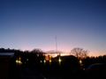
Setting sun @59.2868,17.8025
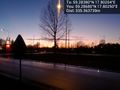
Ham radio antennas @59.2848,17.8040
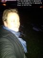
Hmm @59.2838,17.8020

Dark panorama @59.2871,17.8024

Messed up panorama @59.2871,17.8024


Achievements
Carl-Johan earned the Land geohash achievement
|
Carl-Johan earned the Public transport geohash achievement
|