Difference between revisions of "2012-02-29 46 7"
imported>TheOneRing (Created page with "{{meetup graticule | lat=46 | lon=7 | date=2012-02-29 }} == Location == The geohash is on a field near Thun. == Who went == TheOneRing - by public transport...") |
imported>FippeBot m (Location) |
||
| (7 intermediate revisions by 2 users not shown) | |||
| Line 6: | Line 6: | ||
== Location == | == Location == | ||
| − | The geohash is on a | + | The geohash is on a meadow in Höfen near Thun. |
== Who went == | == Who went == | ||
[[User:TheOneRing|TheOneRing]] - by public transport | [[User:TheOneRing|TheOneRing]] - by public transport | ||
| − | == The | + | == The Expedition == |
| − | It | + | === TheOneRing === |
| + | It was leap day and I really wanted to take that opportunity. I left the office around 1pm and took a train to Thun, and from there a bus to Höfen, a small village nearby. The weather conditions were abolutely perfect, sunny and wonderful warm. | ||
| + | |||
| + | From the bus stop it was a short walk (just 250 meter) through the village, when I found the geohash on a meadow on a hill. The view was amazing as the photographs hopefully show. Unfortunately, the conditions didn't really allow to have a picnic so I ate something a little bit later. | ||
| + | |||
| + | I took the usual photos and then walked back to Thun. I passed a still frozen lake but the air temperature was about 20°C, it won't be frozen for long. Thereafter, I got a train back home. Very, very nice. | ||
| + | |||
| + | == Photos == | ||
| + | === TheOneRing === | ||
| + | <gallery perrow="4"> | ||
| + | Image:20120229Ticket.jpg|Today... | ||
| + | Image:20120229GPS.jpg|...at these coordinates... | ||
| + | Image:20120229Geohash2.jpg|...exactly here is the geohash | ||
| + | Image:20120229Me.jpg|Grinning into the Sun | ||
| + | Image:20120229Info.jpg|Some additional information | ||
| + | Image:20120229Geohash1.jpg|The rucksack marks the geohash | ||
| + | Image:20120229Surrounding1.jpg|Panoramic view Western direction... | ||
| + | Image:20120229Panorama2.jpg|...to Southern direction | ||
| + | </gallery> | ||
| + | |||
| + | == Achievements == | ||
| + | {{land geohash | latitude = 46 | longitude = 7 | date = 2012-02-29 | name = TheOneRing}} | ||
| + | {{Public transport geohash | latitude = 46 | longitude = 7 | date = 2012-02-29 | name = TheOneRing }} | ||
| + | {{Leap geohash | year = 2012 | lat = 46 | lon = 7 | name = TheOneRing}} | ||
| + | |||
| + | [[Category:Expeditions]] | ||
| + | [[Category:Expeditions with photos]] | ||
| + | [[Category:Coordinates reached]] | ||
| + | {{location|CH|BE}} | ||
Latest revision as of 02:36, 13 August 2019
| Wed 29 Feb 2012 in 46,7: 46.7230499, 7.5646499 geohashing.info google osm bing/os kml crox |
Contents
Location
The geohash is on a meadow in Höfen near Thun.
Who went
TheOneRing - by public transport
The Expedition
TheOneRing
It was leap day and I really wanted to take that opportunity. I left the office around 1pm and took a train to Thun, and from there a bus to Höfen, a small village nearby. The weather conditions were abolutely perfect, sunny and wonderful warm.
From the bus stop it was a short walk (just 250 meter) through the village, when I found the geohash on a meadow on a hill. The view was amazing as the photographs hopefully show. Unfortunately, the conditions didn't really allow to have a picnic so I ate something a little bit later.
I took the usual photos and then walked back to Thun. I passed a still frozen lake but the air temperature was about 20°C, it won't be frozen for long. Thereafter, I got a train back home. Very, very nice.
Photos
TheOneRing
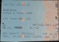
Today...
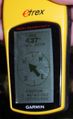
...at these coordinates...
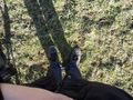
...exactly here is the geohash

Grinning into the Sun
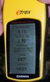
Some additional information
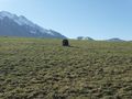
The rucksack marks the geohash
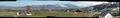
Panoramic view Western direction...
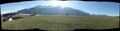
...to Southern direction


Achievements
TheOneRing earned the Land geohash achievement
|
TheOneRing earned the Public transport geohash achievement
|
