Difference between revisions of "2012-02-29 49 8"
imported>Alech (Created page with "{{subst:Expedition |lat = 49 |lon = 8 |date = 2012-02-29 }}") |
imported>Alech (my first expedition!) |
||
| Line 1: | Line 1: | ||
| − | |||
| − | |||
| − | |||
| − | |||
| − | |||
| − | |||
| − | |||
| − | |||
| − | |||
| − | |||
{{meetup graticule | {{meetup graticule | ||
| lat=49 | | lat=49 | ||
| Line 18: | Line 8: | ||
__NOTOC__ | __NOTOC__ | ||
== Location == | == Location == | ||
| − | + | ||
| + | In a meadow next to Zwingenberg-Rodau. | ||
== Participants == | == Participants == | ||
| − | + | [[User:Alech|alech]] | |
== Plans == | == Plans == | ||
| − | + | I had a hunch that my [https://en.wikipedia.org/wiki/Brompton_bicycle Brompton] would arrive that day, so I planned to take it for a test drive from my home to the hash point. The alternative would have been to take a tram and bus and then just walk a bit. This was to be my first expedition and I chose it to be on leap day, so that I only have to worry about my hashiversary (about) every four years ;-) | |
== Expedition == | == Expedition == | ||
| − | + | My Brompton did in fact arrive and I picked it up from the dealer. Getting back home, grabbing my GPS, some water, my camera, my kite (the area looked like one could go for a kite award) I left my home with a rough idea how to get there. Unfortunately, it was already around 5pm when I left, so I knew it was going to get dark soonish. I got lost a few times on the way (although on the tracklog, it now looks less bad than I thought) and passed by the “Erlensee”, a lake I used to go swimming in when I was a child (I leaved even closer by at that time). When I got close to the hashpoint, it was already quite dark. I tried cycling closer, but got stuck in the mud quite some times (not the first time during this trip, too. I really put my new Brompton throught more than I had expected). | |
| + | |||
| + | I managed to push my bike through that mud though (more or less). I passed a hunter who complained that the game was not getting any silence these days (but I think he was not worried about the silence the game was getting but rather that it would not be there for him to shoot it) and that I “was just missing a dog” (damn, I should have brought one, then). When I got closer to the hashpoint, I realized I was on the wrong side of the “Winkelbach”. Unfortunately, it was way larger with a higher dam than it looked like on Google Maps. I pushed my bike on and was getting quite tired. Then I realized that powerlines on your GPS are not roads/tracks. Luckily, a few meters from the powerline there finally was a real track and the bridges that were not recognizable on the GPS map were really bridges. | ||
| + | |||
| + | Even though I was unhappy about not having reached the hashpoint, I decided to pack it in (did I mention it was quite dark already) and pedal back to Alsbach-Hähnlein, where I folded my Brompton, put it on a bus (not without a nice comment from the bus driver what a clever bike I got :-) and the tram and drove back home. Here I am, lots of stuff to drink (better preparation next time, I only brought a (really) small water bottle), roughly cleaning the Brompton from the mud and a hot bath later, ready to go to sleep. I missed the hashpoint, but it was still a nice trip with some memories and some working out (when I looked at the track log I was surprised that I had ridden/pushed about 26kms, much more than I expected). | ||
== Tracklog == | == Tracklog == | ||
| − | + | [http://www.everytrail.com/view_trip.php?trip_id=1468130 on everytrail.com] | |
== Photos == | == Photos == | ||
| − | |||
| − | |||
| − | |||
<gallery perrow="5"> | <gallery perrow="5"> | ||
| + | Image:2012_02_29_49_8_alech_erlensee.jpg | Erlensee in the evening | ||
| + | Image:2012_02_29_49_8_alech_winkelbach_fail.jpg | Fail: there is a Winkelbach between you and the hashpoint | ||
| + | Image:2012_02_29_49_8_alech_dirty_brompton.jpg | My poor new Brompton, all muddy | ||
| + | Image:2012_02_29_49_8_alech_dirty_trousers.jpg | Did I mention it was muddy? | ||
</gallery> | </gallery> | ||
| − | |||
| − | |||
| − | |||
| − | |||
| − | |||
| − | |||
| − | |||
| − | |||
| − | |||
| − | |||
| − | |||
| − | |||
| − | |||
| − | |||
| − | |||
[[Category:Expeditions]] | [[Category:Expeditions]] | ||
| − | |||
[[Category:Expeditions with photos]] | [[Category:Expeditions with photos]] | ||
| − | |||
| − | |||
| − | |||
| − | |||
| − | |||
| − | |||
| − | |||
[[Category:Coordinates not reached]] | [[Category:Coordinates not reached]] | ||
| − | |||
| − | |||
| − | |||
| − | |||
[[Category:Not reached - Did not attempt]] when you went to an alternate location, or decided early on to abort the expedition. | [[Category:Not reached - Did not attempt]] when you went to an alternate location, or decided early on to abort the expedition. | ||
| − | |||
Revision as of 22:29, 29 February 2012
| Wed 29 Feb 2012 in 49,8: 49.7230499, 8.5646499 geohashing.info google osm bing/os kml crox |
Location
In a meadow next to Zwingenberg-Rodau.
Participants
Plans
I had a hunch that my Brompton would arrive that day, so I planned to take it for a test drive from my home to the hash point. The alternative would have been to take a tram and bus and then just walk a bit. This was to be my first expedition and I chose it to be on leap day, so that I only have to worry about my hashiversary (about) every four years ;-)
Expedition
My Brompton did in fact arrive and I picked it up from the dealer. Getting back home, grabbing my GPS, some water, my camera, my kite (the area looked like one could go for a kite award) I left my home with a rough idea how to get there. Unfortunately, it was already around 5pm when I left, so I knew it was going to get dark soonish. I got lost a few times on the way (although on the tracklog, it now looks less bad than I thought) and passed by the “Erlensee”, a lake I used to go swimming in when I was a child (I leaved even closer by at that time). When I got close to the hashpoint, it was already quite dark. I tried cycling closer, but got stuck in the mud quite some times (not the first time during this trip, too. I really put my new Brompton throught more than I had expected).
I managed to push my bike through that mud though (more or less). I passed a hunter who complained that the game was not getting any silence these days (but I think he was not worried about the silence the game was getting but rather that it would not be there for him to shoot it) and that I “was just missing a dog” (damn, I should have brought one, then). When I got closer to the hashpoint, I realized I was on the wrong side of the “Winkelbach”. Unfortunately, it was way larger with a higher dam than it looked like on Google Maps. I pushed my bike on and was getting quite tired. Then I realized that powerlines on your GPS are not roads/tracks. Luckily, a few meters from the powerline there finally was a real track and the bridges that were not recognizable on the GPS map were really bridges.
Even though I was unhappy about not having reached the hashpoint, I decided to pack it in (did I mention it was quite dark already) and pedal back to Alsbach-Hähnlein, where I folded my Brompton, put it on a bus (not without a nice comment from the bus driver what a clever bike I got :-) and the tram and drove back home. Here I am, lots of stuff to drink (better preparation next time, I only brought a (really) small water bottle), roughly cleaning the Brompton from the mud and a hot bath later, ready to go to sleep. I missed the hashpoint, but it was still a nice trip with some memories and some working out (when I looked at the track log I was surprised that I had ridden/pushed about 26kms, much more than I expected).
Tracklog
Photos
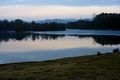
Erlensee in the evening
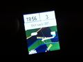
Fail: there is a Winkelbach between you and the hashpoint
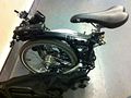
My poor new Brompton, all muddy
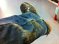
Did I mention it was muddy?


when you went to an alternate location, or decided early on to abort the expedition.