Difference between revisions of "2012-03-03 40 -86"
imported>Dvdwinter9 (→Achievements) |
imported>Dvdwinter9 (→Expedition) |
||
| Line 31: | Line 31: | ||
We left campus around 12:30 PM. Went across the consistently-swelled Wabash River, through downtown Lafayette, and further east. We passed classic Lafayette landmarks such as Alcoa, the Tippecanoe Mall, and Tate & Lyle. As we got closer, we missed a turn and had to stop and turn around. Finally, we reached the farmland where the hash was. | We left campus around 12:30 PM. Went across the consistently-swelled Wabash River, through downtown Lafayette, and further east. We passed classic Lafayette landmarks such as Alcoa, the Tippecanoe Mall, and Tate & Lyle. As we got closer, we missed a turn and had to stop and turn around. Finally, we reached the farmland where the hash was. | ||
| − | We pulled to the side of the road debated whether or not to ask the property owner if we could | + | We pulled to the side of the road and debated whether or not to ask the property owner if we could go on his land for 10 minutes. We ended up going for it, and the explanation went surprisingly well. I took some pictures and screenshots, and we piled back into the car and went home, stopping at Speedway on the way back. |
All in all, it was just the perfect distance for breaking our hash-cherries and went off without a hitch, and we all had lots of fun. | All in all, it was just the perfect distance for breaking our hash-cherries and went off without a hitch, and we all had lots of fun. | ||
Revision as of 21:01, 4 March 2012
| Sat 3 Mar 2012 in 40,-86: 40.3299215, -86.8193385 geohashing.info google osm bing/os kml crox |
Location
Plot of farmland just outside of North Crane, Indiana.
Participants
- David
- Michael
- Paul
- Josh
Plans
We planned to leave from Cary at noon, drive to the location, ask the property owner if we can go onto their land, and complete the expedition.
Expedition
We left campus around 12:30 PM. Went across the consistently-swelled Wabash River, through downtown Lafayette, and further east. We passed classic Lafayette landmarks such as Alcoa, the Tippecanoe Mall, and Tate & Lyle. As we got closer, we missed a turn and had to stop and turn around. Finally, we reached the farmland where the hash was.
We pulled to the side of the road and debated whether or not to ask the property owner if we could go on his land for 10 minutes. We ended up going for it, and the explanation went surprisingly well. I took some pictures and screenshots, and we piled back into the car and went home, stopping at Speedway on the way back.
All in all, it was just the perfect distance for breaking our hash-cherries and went off without a hitch, and we all had lots of fun.
Tracklog
Photos
Whoops! Turn around!
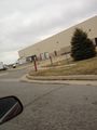
"Correctional canteen? Like correctional facility? Yeah, we're getting out of here."
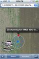
As close as I could get before it started jumping around.
Chariot of the Gods

David's Stupid Grin
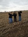
Paul, Josh, and Michael's Stupid Grins
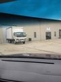
HUGE yard of trailers, as far as the eye could see, outside of Tate & Lyle. Insight as to their purpose and reason for seemingly just lying there would be appreciated.


Achievements
David earned the Land geohash achievement
|

David earned the Ambassador achievement
|
David earned the Drag-along achievement
|