Difference between revisions of "2012-03-03 50 -122"
imported>Wijnland (create expedition) |
m (per Renaming Proposal) |
||
| (5 intermediate revisions by 4 users not shown) | |||
| Line 1: | Line 1: | ||
| − | + | [[Image:{{{image|2012030350-123_1.jpg}}}|thumb |left | 400px]] | |
| − | |||
| − | |||
| − | |||
| − | |||
| − | |||
| − | |||
| − | |||
{{meetup graticule | {{meetup graticule | ||
| lat=50 | | lat=50 | ||
| Line 22: | Line 15: | ||
== Participants == | == Participants == | ||
| − | * [[User:Wijnland|Wijnland]] | + | * [[User:Wijnland|Wijnland]] (+1) |
| + | * Jocelyn | ||
| + | |||
| + | * [[User:Rhonda|Rhonda]] | ||
== Plans == | == Plans == | ||
| − | + | Will go to Whistler to ski and then geohash in the afternoon for a true xkcd Saturday meetup. Plus this is a Virgin Graticule expedition! | |
| + | |||
| + | I will drive my Van and still have seats empty! - Wijnland | ||
== Expedition == | == Expedition == | ||
| − | + | * [[User:Wijnland |Wijnland]]. | |
| + | I convinced one of my skiing friends to join me for this geohash. The location was on a hill in a forest near Pemberton. Access to the forest was over a gravel path and some agricultural land. We went up to the house to ask permission and found nobody there and proceeded into the forest. On the geohash location we found a marked tree with orange ribbon and one with strange cutmarks. The marks looked fresh and were surely human as they were kind of square. I thought somebody had beat me to this hash. | ||
| + | |||
| + | On our way out we met the owner of the house who granted us passage back to the road where we met Rhonda who also made her way there. She decided not to go up anymore as the owners were not to enthusiastic about our presence. | ||
| − | |||
| − | + | == Photos == | |
<gallery perrow="5"> | <gallery perrow="5"> | ||
| − | Image:2012030350- | + | Image:2012030350-123_gps.jpg | Coordinates Reached |
| + | Image:2012030350-123_grin.jpg | Me a little wet, but satisfied on location | ||
| + | Image:2012030350-123 trees.jpg | Did somebody reach the location before me?, A strange way of marking here... but it seemed fresh | ||
| + | Image:2012030350-123_forest.jpg | Impression of the forest. | ||
| + | Image:2012030350-123_gate.jpg | Open gate | ||
| + | Image:2012030350-123 meetup.jpg | Wijnland and Rhonda | ||
</gallery> | </gallery> | ||
== Achievements == | == Achievements == | ||
{{#vardefine:ribbonwidth|800px}} | {{#vardefine:ribbonwidth|800px}} | ||
| − | -- | + | |
| + | {{Graticule unlocked | ||
| + | | latitude = 50 | ||
| + | | longitude = -122 | ||
| + | | date = 2012-03-03 | ||
| + | | name = Wijnland | ||
| + | | image = 2012030350-123_gps.jpg | ||
| + | }} | ||
| + | {{drag-along | ||
| + | | latitude = 50 | ||
| + | | longitude = -122 | ||
| + | | date = 2012-03-03 | ||
| + | | partner = Jocelyn | ||
| + | | name = Wijnland | ||
| + | | image = 2012030350-123_1.jpg | ||
| + | }} | ||
[[Category:Expeditions]] | [[Category:Expeditions]] | ||
| + | [[Category:Expeditions with photos]] | ||
| + | [[Category:Coordinates reached]] | ||
| + | {{location|CA|BC|SL}} | ||
Latest revision as of 05:44, 20 March 2024

| Sat 3 Mar 2012 in 50,-122: 50.3299215, -122.8193385 geohashing.info google osm bing/os kml crox |
Location
Pemberton, BC
Participants
- Wijnland (+1)
- Jocelyn
Plans
Will go to Whistler to ski and then geohash in the afternoon for a true xkcd Saturday meetup. Plus this is a Virgin Graticule expedition!
I will drive my Van and still have seats empty! - Wijnland
Expedition
I convinced one of my skiing friends to join me for this geohash. The location was on a hill in a forest near Pemberton. Access to the forest was over a gravel path and some agricultural land. We went up to the house to ask permission and found nobody there and proceeded into the forest. On the geohash location we found a marked tree with orange ribbon and one with strange cutmarks. The marks looked fresh and were surely human as they were kind of square. I thought somebody had beat me to this hash.
On our way out we met the owner of the house who granted us passage back to the road where we met Rhonda who also made her way there. She decided not to go up anymore as the owners were not to enthusiastic about our presence.
Photos
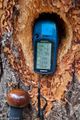
Coordinates Reached
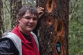
Me a little wet, but satisfied on location
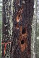
Did somebody reach the location before me?, A strange way of marking here... but it seemed fresh
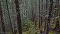
Impression of the forest.
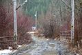
Open gate
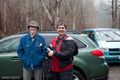
Wijnland and Rhonda


Achievements
Wijnland earned the Graticule Unlocked Achievement
|
Wijnland earned the Drag-along achievement
|