Difference between revisions of "2012-03-05 54 -3"
imported>Matingslinkys |
imported>FippeBot m (Location) |
||
| (8 intermediate revisions by 4 users not shown) | |||
| Line 1: | Line 1: | ||
| − | |||
| − | |||
| − | |||
| − | |||
| − | |||
| − | |||
| − | |||
| − | |||
| − | |||
| − | |||
{{meetup graticule | {{meetup graticule | ||
| lat=54 | | lat=54 | ||
| Line 15: | Line 5: | ||
}} | }} | ||
| − | + | ||
__NOTOC__ | __NOTOC__ | ||
== Location == | == Location == | ||
| Line 26: | Line 16: | ||
== Plans == | == Plans == | ||
| − | During | + | During lunch-break whilst studiously studying on placement, we idly flicked through the archives of ''xkcd'' and decided to see where the nearest geohash was, having intended, but never actually succeeded in going out to find one before. |
| + | |||
| + | Glory be, the nearest one was not only within striking distance, but pleasantly easily accessible, being in a field a few yards from a road. Upon finishing the shift we bravely sallied forth... | ||
== Expedition == | == Expedition == | ||
| − | + | Getting there was rather simple, and a nice drive in the glorious afternoon sunlight. Following the SatNav through the twisty back lanes of Cumbria we arrived at the side of the road with nary a negative thought (well, except for the near grounding of the car and unexpected wheel-spinning, complete with dramatic spray of mud). | |
| + | |||
| + | Having gone straight from work we ''so'' nearly qualified for the formal attire achievement (however, it usually take a funeral to get me into a tie...) this did mean that we were in very shiny, yet entirely impractical footwear. Finding a useful gate, and we had several slightly slippy and near-comedic moments navigating mud, sheep doings and general bogginess we took a couple of photographs, and proceeded to look slightly silly congratulating one another for standing in a muddy field a few yards from the road. | ||
| + | |||
| + | Bam. Hash reached. Then we went home, feeling the pleasant warmth of deflowering a graticule... | ||
| + | |||
| + | We apologise for the lack of other photographs, as this was our first hash, and we were unaware of the etiquette, or the proof requirements of photos of GPS devices. Things will be better next time... | ||
== Tracklog == | == Tracklog == | ||
| Line 35: | Line 33: | ||
== Photos == | == Photos == | ||
| − | |||
| − | |||
| − | |||
<gallery perrow="5"> | <gallery perrow="5"> | ||
| + | File:IMG_20120305_170325.jpg | RunawayBomber forcing a Stupid Grin™ | ||
| + | File:IMG_20120305_170300.jpg | Matingslinkys' Stupid Grin™ | ||
</gallery> | </gallery> | ||
| Line 45: | Line 42: | ||
<!-- Add any achievement ribbons you earned below, or remove this section --> | <!-- Add any achievement ribbons you earned below, or remove this section --> | ||
| + | {{land geohash | latitude = 54 | longitude = -3 | date = 2012-03-05 | name = RunawayBomber and Matingslinkys }} | ||
| − | |||
| − | |||
| − | |||
| − | + | [[Category:Expeditions]] | |
| − | |||
| − | [[Category: | ||
| − | |||
| − | |||
| − | |||
| − | |||
[[Category:Expeditions with photos]] | [[Category:Expeditions with photos]] | ||
| − | + | ||
| − | |||
| − | |||
| − | |||
| − | |||
[[Category:Coordinates reached]] | [[Category:Coordinates reached]] | ||
| − | + | {{location|GB|ENG|CMA}} | |
| − | |||
| − | |||
| − | |||
| − | |||
| − | |||
| − | |||
| − | |||
| − | |||
| − | |||
Latest revision as of 02:44, 13 August 2019
| Mon 5 Mar 2012 in 54,-3: 54.7158306, -3.1761657 geohashing.info google osm bing/os kml crox |
Location
Uldale, Cumbria, United Kingdom.
Participants
Plans
During lunch-break whilst studiously studying on placement, we idly flicked through the archives of xkcd and decided to see where the nearest geohash was, having intended, but never actually succeeded in going out to find one before.
Glory be, the nearest one was not only within striking distance, but pleasantly easily accessible, being in a field a few yards from a road. Upon finishing the shift we bravely sallied forth...
Expedition
Getting there was rather simple, and a nice drive in the glorious afternoon sunlight. Following the SatNav through the twisty back lanes of Cumbria we arrived at the side of the road with nary a negative thought (well, except for the near grounding of the car and unexpected wheel-spinning, complete with dramatic spray of mud).
Having gone straight from work we so nearly qualified for the formal attire achievement (however, it usually take a funeral to get me into a tie...) this did mean that we were in very shiny, yet entirely impractical footwear. Finding a useful gate, and we had several slightly slippy and near-comedic moments navigating mud, sheep doings and general bogginess we took a couple of photographs, and proceeded to look slightly silly congratulating one another for standing in a muddy field a few yards from the road.
Bam. Hash reached. Then we went home, feeling the pleasant warmth of deflowering a graticule...
We apologise for the lack of other photographs, as this was our first hash, and we were unaware of the etiquette, or the proof requirements of photos of GPS devices. Things will be better next time...
Tracklog
Photos
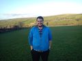
RunawayBomber forcing a Stupid Grin™
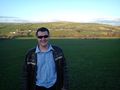
Matingslinkys' Stupid Grin™


Achievements
RunawayBomber and Matingslinkys earned the Land geohash achievement
|