Difference between revisions of "2012-03-09 43 1"
imported>Paul Kauphart |
m (per Renaming Proposal) |
||
| (6 intermediate revisions by 2 users not shown) | |||
| Line 14: | Line 14: | ||
}} | }} | ||
| − | + | Wohooo ! Expedition successfull !! | |
| − | Expedition | ||
<!-- edit as necessary --> | <!-- edit as necessary --> | ||
| Line 32: | Line 31: | ||
== Expedition == | == Expedition == | ||
<!-- how it all turned out. your narrative goes here. --> | <!-- how it all turned out. your narrative goes here. --> | ||
| + | |||
| + | I left work that day at the worst possible time, ie the time when everybody leaves work and driving around Toulouse is a true nightmare. I still managed to reach the place before sunset. Parked the car near the résidential area, hoping the point wouldn't be in some garden (didn't seemed to be on googlemap, but you never know). | ||
| + | |||
| + | I got to the point, happy, it's next to the road and a few meter in front of a house front gate. The house dog starts barking behind the gate, I completly ignore it and start taking pretty pictures of the neighbouhood (the big white building on the satellite picture is gone by the way). I'm nearly done when a guy approaches me, asking what I'm doing here. I explain him the concept of the game, telling him I take a fiew picture of the surrounding. He replies I should be a little more carefull, I could be dangerous wandering like that alone, I should avoid doing that at night. While at first it looked like simply a curious man, he was insistent, I then realised it was actually threat... well the two "friendly" punches in the shoulder were a dead givaway, took me completly flat-footed. At this point I figured a polite retreat was the best option, so I took my car and left. I parked on the other side of the roundabout, took a fiew more picture of the local area, a picture of the actual hashpoint, and left. Trip on the way back wasn't as bad as the way out, and despite comming home much later than originaly planned, I was pleased that the first expedition was actually, a success. | ||
| + | |||
| + | Picture are there ! (part of them) | ||
== Tracklog == | == Tracklog == | ||
<!-- if your GPS device keeps a log, you may post a link here --> | <!-- if your GPS device keeps a log, you may post a link here --> | ||
| + | None, I don't have any. | ||
== Photos == | == Photos == | ||
| Line 41: | Line 47: | ||
--> | --> | ||
<gallery perrow="5"> | <gallery perrow="5"> | ||
| + | Image:2012-03-09 43 1 0.jpg|Preparing the expedition | ||
| + | Image:2012-03-09 43 1 1.jpg|Almost there | ||
| + | Image:2012-03-09 43 1 2.jpg|Line of houses south of the spot | ||
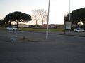
| + | Image:2012-03-09 43 1 3.jpg|A grin, and the big white roundabout, picture is taken a couple of meters from the spot | ||
| + | Image:2012-03-09 43 1 4.jpg|The roundabout, from the other side | ||
</gallery> | </gallery> | ||
| Line 46: | Line 57: | ||
{{#vardefine:ribbonwidth|800px}} | {{#vardefine:ribbonwidth|800px}} | ||
<!-- Add any achievement ribbons you earned below, or remove this section --> | <!-- Add any achievement ribbons you earned below, or remove this section --> | ||
| + | {{land geohash | ||
| + | | latitude = 43 | ||
| + | | longitude = 1 | ||
| + | | date = 2012-03-09 | ||
| + | | name = [[User:Paul Kauphart|Paul Kauphart]] | ||
| + | }} | ||
| + | {{No_batteries_geohash | ||
| + | | latitude = 43 | ||
| + | | longitude = 1 | ||
| + | | date = 2012-03-09 | ||
| + | | name = [[User:Paul Kauphart|Paul Kauphart]] | ||
| + | }} | ||
| + | {{Graticule unlocked | ||
| + | |||
| + | | latitude = 43 | ||
| + | | longitude = 1 | ||
| + | | date = 2012-03-09 | ||
| + | | name = [[User:Paul Kauphart|Paul Kauphart]] | ||
| + | }} | ||
<!-- =============== USEFUL CATEGORIES FOLLOW ================ | <!-- =============== USEFUL CATEGORIES FOLLOW ================ | ||
Delete the next line ONLY if you have chosen the appropriate categories below. If you are unsure, don't worry. People will read your report and help you with the classification. --> | Delete the next line ONLY if you have chosen the appropriate categories below. If you are unsure, don't worry. People will read your report and help you with the classification. --> | ||
| − | [[Category: | + | [[Category:Expeditions]] |
| + | [[Category:Expeditions with photos]] | ||
| + | [[Category:Expedition without GPS]] | ||
| + | [[Category:Coordinates reached]] | ||
<!-- Potential categories. Please include all the ones appropriate to your expedition --> | <!-- Potential categories. Please include all the ones appropriate to your expedition --> | ||
| Line 77: | Line 110: | ||
[[Category:Not reached - Did not attempt]] when you went to an alternate location, or decided early on to abort the expedition. | [[Category:Not reached - Did not attempt]] when you went to an alternate location, or decided early on to abort the expedition. | ||
--> | --> | ||
| + | {{location|FR|31}} | ||
Latest revision as of 05:43, 20 March 2024
| Fri 9 Mar 2012 in 43,1: 43.6092115, 1.3512291 geohashing.info google osm bing/os kml crox |
Wohooo ! Expedition successfull !!
Location
Colomiers
Participants
Plans
It's not far from town center, so I just recovered an old digital camera at home, and I plan on making a small detour there on my way out of work, with nothing more than a printed screensave of the google satellite view.
Expedition
I left work that day at the worst possible time, ie the time when everybody leaves work and driving around Toulouse is a true nightmare. I still managed to reach the place before sunset. Parked the car near the résidential area, hoping the point wouldn't be in some garden (didn't seemed to be on googlemap, but you never know).
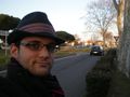
I got to the point, happy, it's next to the road and a few meter in front of a house front gate. The house dog starts barking behind the gate, I completly ignore it and start taking pretty pictures of the neighbouhood (the big white building on the satellite picture is gone by the way). I'm nearly done when a guy approaches me, asking what I'm doing here. I explain him the concept of the game, telling him I take a fiew picture of the surrounding. He replies I should be a little more carefull, I could be dangerous wandering like that alone, I should avoid doing that at night. While at first it looked like simply a curious man, he was insistent, I then realised it was actually threat... well the two "friendly" punches in the shoulder were a dead givaway, took me completly flat-footed. At this point I figured a polite retreat was the best option, so I took my car and left. I parked on the other side of the roundabout, took a fiew more picture of the local area, a picture of the actual hashpoint, and left. Trip on the way back wasn't as bad as the way out, and despite comming home much later than originaly planned, I was pleased that the first expedition was actually, a success.
Picture are there ! (part of them)
Tracklog
None, I don't have any.
Photos
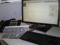
Preparing the expedition
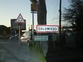
Almost there
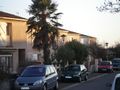
Line of houses south of the spot
A grin, and the big white roundabout, picture is taken a couple of meters from the spot
The roundabout, from the other side


Achievements
Paul Kauphart earned the Land geohash achievement
|
Paul Kauphart earned the No Batteries Geohash Achievement
|
Paul Kauphart earned the Graticule Unlocked Achievement
|