Difference between revisions of "2012-03-10 34 -118"
From Geohashing
imported>S0meb0dy (→Participants) |
imported>FippeBot m (Location) |
||
| (4 intermediate revisions by 2 users not shown) | |||
| Line 1: | Line 1: | ||
| − | |||
<!-- If you did not specify these parameters in the template, please substitute appropriate values for IMAGE, LAT, LON, and DATE (YYYY-MM-DD format) | <!-- If you did not specify these parameters in the template, please substitute appropriate values for IMAGE, LAT, LON, and DATE (YYYY-MM-DD format) | ||
| Line 15: | Line 14: | ||
}} | }} | ||
| − | + | ||
__NOTOC__ | __NOTOC__ | ||
== Location == | == Location == | ||
| − | + | ||
| + | Down an Alley | ||
== Participants == | == Participants == | ||
| − | + | ||
* [[User:s0meb0dy|s0meb0dy]] | * [[User:s0meb0dy|s0meb0dy]] | ||
== Plans == | == Plans == | ||
| − | + | ||
| + | I looked at this on Friday and all appeared okay. | ||
| + | |||
| + | Didn't notice the fence on the Google map sat image. | ||
== Expedition == | == Expedition == | ||
| − | + | ||
| + | The geohash was half way down the alley in the pic below. Does 200ft away count as making it? | ||
| + | |||
| + | I think I'll have to mark this as a No Trespassing Achievement instead. | ||
| + | |||
| + | s0meb0dy | ||
== Tracklog == | == Tracklog == | ||
| Line 44: | Line 52: | ||
== Achievements == | == Achievements == | ||
{{#vardefine:ribbonwidth|800px}} | {{#vardefine:ribbonwidth|800px}} | ||
| − | |||
| + | {{No trespassing | latitude = 34 | longitude = -118 | date = 2012-03-10 | name = s0meb0dy }} | ||
| − | |||
| − | |||
| − | |||
| − | + | [[Category:Expeditions]] | |
| − | |||
| − | [[Category: | ||
| − | |||
| − | |||
| − | |||
| − | |||
[[Category:Expeditions with photos]] | [[Category:Expeditions with photos]] | ||
| − | |||
| − | |||
| − | |||
| − | |||
| − | |||
| − | |||
| − | |||
| − | |||
[[Category:Coordinates not reached]] | [[Category:Coordinates not reached]] | ||
| − | + | [[Category:Not reached - No public access]] | |
| − | + | {{location|US|CA|LO}} | |
| − | [[Category:Not reached - No public access]] | ||
| − | |||
| − | |||
| − | |||
Latest revision as of 02:49, 13 August 2019
| Sat 10 Mar 2012 in 34,-118: 34.2001308, -118.3999547 geohashing.info google osm bing/os kml crox |
Location
Down an Alley
Participants
Plans
I looked at this on Friday and all appeared okay.
Didn't notice the fence on the Google map sat image.
Expedition
The geohash was half way down the alley in the pic below. Does 200ft away count as making it?
I think I'll have to mark this as a No Trespassing Achievement instead.
s0meb0dy
Tracklog
Photos
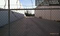
Almost there. Missed it by 200 feet. @34.2007,-118.4000

Achievements
s0meb0dy earned the No trespassing consolation prize
|