Difference between revisions of "2012-03-12 -35 149"
From Geohashing
imported>Sootku (Created page with "{{subst:Expedition |lat = latitude of graticule |lon = longitude of graticule |date = date of expedition, in YYYY-MM-DD format }}") |
imported>FippeBot m (Location) |
||
| (7 intermediate revisions by 5 users not shown) | |||
| Line 1: | Line 1: | ||
| + | <!-- If you did not specify these parameters in the template, please substitute appropriate values for IMAGE, LAT, LON, and DATE (YYYY-MM-DD format) | ||
| − | + | [[Image:{{{image|2012-03-12 -35.266007 149.078646 Aranda Nature Park, Canberra-small.JPG.jpg}}}|thumb|left]] | |
| − | [[Image:{{{image| | + | [[Image:{{{image|2012-03-12 -35 149.jpg}}}|thumb|left]] |
Remove this section if you don't want an image at the top (left) of your report. You should remove the "Image:" or "File:" | Remove this section if you don't want an image at the top (left) of your report. You should remove the "Image:" or "File:" | ||
| Line 10: | Line 11: | ||
--> | --> | ||
{{meetup graticule | {{meetup graticule | ||
| − | | lat= | + | | lat=-35 |
| − | | lon= | + | | lon=149 |
| − | | date= | + | | date=2012-03-12 |
}} | }} | ||
| − | + | ||
__NOTOC__ | __NOTOC__ | ||
== Location == | == Location == | ||
| − | + | * Canberra Nature Park, Aranda Bushland; west of Black Mountain. | |
| + | * behind black mountain somewhere in the bushes; lots of surprised roos | ||
== Participants == | == Participants == | ||
| − | + | * Exped 1: [[User:1PE|1PE]] (separate from [[User:Sootku|Sootku]] on the same day.) | |
| + | ** Picture was ghastly; re-staged next morning near the carpark. | ||
| + | * Exped 2: [[User:Sootku|Sootku]] - just me and my bike | ||
== Plans == | == Plans == | ||
| Line 28: | Line 32: | ||
== Expedition == | == Expedition == | ||
<!-- how it all turned out. your narrative goes here. --> | <!-- how it all turned out. your narrative goes here. --> | ||
| + | # Fairly simple find. Unremarkable bushland. Damp from recent rain. (There before sunset.) | ||
| + | # piece of pie, just a couple of meters off the track and through low grass. the way back was all downhill just after sunset | ||
== Tracklog == | == Tracklog == | ||
| Line 37: | Line 43: | ||
--> | --> | ||
<gallery perrow="5"> | <gallery perrow="5"> | ||
| + | File:2012-03-12 -35.266007 149.078646 Aranda Nature Park, Canberra-small.JPG.jpg | Yes, I'm not shaving at present. | ||
| + | |||
| + | File:2012-03-12 -35 149.jpg | [[User:Sootku|Sootku]]'s bike | ||
</gallery> | </gallery> | ||
| Line 43: | Line 52: | ||
<!-- Add any achievement ribbons you earned below, or remove this section --> | <!-- Add any achievement ribbons you earned below, or remove this section --> | ||
| + | * Land geohash | ||
| − | |||
| − | |||
| − | |||
| − | |||
| − | |||
| − | |||
| − | |||
| − | |||
| − | |||
[[Category:Expeditions]] | [[Category:Expeditions]] | ||
| − | |||
[[Category:Expeditions with photos]] | [[Category:Expeditions with photos]] | ||
| − | + | ||
| − | |||
| − | |||
| − | |||
| − | |||
[[Category:Coordinates reached]] | [[Category:Coordinates reached]] | ||
| − | + | {{location|AU|ACT}} | |
| − | |||
| − | |||
| − | |||
| − | |||
| − | |||
| − | |||
| − | |||
| − | |||
| − | |||
Latest revision as of 02:52, 13 August 2019
| Mon 12 Mar 2012 in -35,149: -35.2660062, 149.0786461 geohashing.info google osm bing/os kml crox |
Location
- Canberra Nature Park, Aranda Bushland; west of Black Mountain.
- behind black mountain somewhere in the bushes; lots of surprised roos
Participants
- Exped 1: 1PE (separate from Sootku on the same day.)
- Picture was ghastly; re-staged next morning near the carpark.
- Exped 2: Sootku - just me and my bike
Plans
Expedition
- Fairly simple find. Unremarkable bushland. Damp from recent rain. (There before sunset.)
- piece of pie, just a couple of meters off the track and through low grass. the way back was all downhill just after sunset
Tracklog
Photos
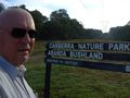
Yes, I'm not shaving at present.
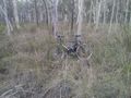
Sootku's bike


Achievements
- Land geohash