Difference between revisions of "2012-03-12 43 -2"
imported>Lizwiz (→The Expedition) |
m (per Renaming Proposal) |
||
| (6 intermediate revisions by 4 users not shown) | |||
| Line 1: | Line 1: | ||
| − | + | <!-- If you did not specify these parameters in the template, please substitute appropriate values for IMAGE, LAT, LON, and DATE (YYYY-MM-DD format) | |
| − | |||
| − | == | + | [[Image:{{{image|IMAGE}}}|thumb|left]] |
| + | |||
| + | Remove this section if you don't want an image at the top (left) of your report. You should remove the "Image:" or "File:" | ||
| + | tag from your image file name, and replace the all upper-case word IMAGE in the above line. | ||
| + | |||
| + | And DON'T FORGET to add your expedition and the best photo you took to the gallery on the Main Page! We'd love to read your report, but that means we first have to discover it! | ||
| + | --> | ||
| + | {{meetup graticule | ||
| + | | lat=43 | ||
| + | | lon=-2 | ||
| + | | date=2012-03-12 | ||
| + | }} | ||
| + | |||
| + | |||
| + | __NOTOC__ | ||
| + | == Location == | ||
| + | Hashpoint was about 60m into a forest around Usurbil, a town near San Sebastián. | ||
| + | |||
| + | |||
| + | == Participants == | ||
| + | * [[User:lizwiz|LizWiz]] | ||
| + | |||
| + | == Plans == | ||
| + | Use the lunch break to take the 10min train ride to Usurbil, and bike the rest of the way. | ||
| + | |||
| + | == Expedition == | ||
I'd been consumed by the concept of geohashing for the past week, checking nearby hashpoints daily in spite of not yet having a gps, and planning many conquests in a yet unhashed area. So when the hashpoint turned out to be less than 20km from my workplace, I didn't want to miss the opportunity. I used public transport (train) to get to the hash-town Usurbil, and then rode my bicycle (ca. 5km). | I'd been consumed by the concept of geohashing for the past week, checking nearby hashpoints daily in spite of not yet having a gps, and planning many conquests in a yet unhashed area. So when the hashpoint turned out to be less than 20km from my workplace, I didn't want to miss the opportunity. I used public transport (train) to get to the hash-town Usurbil, and then rode my bicycle (ca. 5km). | ||
In spite of not having a GPS, GoogleMaps allowed me to accurately determine when I was at a distance of about 60m SSE from the hashpoint thanks to some power-lines crossing the path. When I arrived to the point on the path where the powerlines were directly overhead, I ventured off the path into the forest on foot (in a NNW-ish direction, as estimated by powerlines&path) to get as close as possible to the actual hashpoint. There were poky brambles. | In spite of not having a GPS, GoogleMaps allowed me to accurately determine when I was at a distance of about 60m SSE from the hashpoint thanks to some power-lines crossing the path. When I arrived to the point on the path where the powerlines were directly overhead, I ventured off the path into the forest on foot (in a NNW-ish direction, as estimated by powerlines&path) to get as close as possible to the actual hashpoint. There were poky brambles. | ||
| − | == | + | == Photos == |
| − | + | <!-- Insert pictures between the gallery tags using the following format: | |
| + | Image:2010-##-## ## ## Alpha.jpg | Witty Comment | ||
| + | --> | ||
| + | |||
| + | |||
| + | <gallery perrow="5"> | ||
| + | Image:2012_03_12_43_-2_map.jpg | My sole guide | ||
| + | Image:2012_03_12_43_-2_powerlines.jpg | Power lines directly above me | ||
| + | Image:2012_03_12_43_-2_me.jpg | In the hash-forest | ||
| + | </gallery> | ||
| − | {{ | + | == Achievements == |
| + | I proudly display my <s>two</s> four first ribbons: | ||
| + | |||
| + | {{Graticule unlocked | ||
| latitude = 43 | | latitude = 43 | ||
| Line 27: | Line 63: | ||
}} | }} | ||
| + | |||
| + | {{Land_geohash | ||
| + | |||
| + | | latitude = 43 | ||
| + | | longitude = -2 | ||
| + | | date = 2012-03-12 | ||
| + | | name = LizWiz | ||
| + | |||
| + | }} | ||
| + | |||
| + | {{Public transport_geohash | ||
| + | |||
| + | | latitude = 43 | ||
| + | | longitude = -2 | ||
| + | | date = 2012-03-12 | ||
| + | | name = LizWiz | ||
| + | |||
| + | }} | ||
| + | |||
| + | |||
| + | [[Category:Expeditions]] | ||
| + | [[Category:Expeditions with photos]] | ||
| + | [[Category:Expedition without GPS]] | ||
| + | [[Category:Coordinates reached]] | ||
| + | {{location|ES|PV|SS}} | ||
Latest revision as of 05:43, 20 March 2024
| Mon 12 Mar 2012 in 43,-2: 43.2660062, -2.0786461 geohashing.info google osm bing/os kml crox |
Location
Hashpoint was about 60m into a forest around Usurbil, a town near San Sebastián.
Participants
Plans
Use the lunch break to take the 10min train ride to Usurbil, and bike the rest of the way.
Expedition
I'd been consumed by the concept of geohashing for the past week, checking nearby hashpoints daily in spite of not yet having a gps, and planning many conquests in a yet unhashed area. So when the hashpoint turned out to be less than 20km from my workplace, I didn't want to miss the opportunity. I used public transport (train) to get to the hash-town Usurbil, and then rode my bicycle (ca. 5km).
In spite of not having a GPS, GoogleMaps allowed me to accurately determine when I was at a distance of about 60m SSE from the hashpoint thanks to some power-lines crossing the path. When I arrived to the point on the path where the powerlines were directly overhead, I ventured off the path into the forest on foot (in a NNW-ish direction, as estimated by powerlines&path) to get as close as possible to the actual hashpoint. There were poky brambles.
Photos
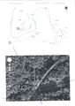
My sole guide
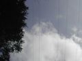
Power lines directly above me
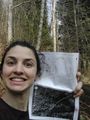
In the hash-forest


Achievements
I proudly display my two four first ribbons:
LizWiz earned the Graticule Unlocked Achievement
|
LizWiz earned the No Batteries Geohash Achievement
|
LizWiz earned the Land geohash achievement
|
LizWiz earned the Public transport geohash achievement
|