Difference between revisions of "2012-03-12 59 18"
imported>Zeot (→Expedition) |
imported>Cjk |
||
| Line 1: | Line 1: | ||
| − | + | [[Image:{{{image|423438_370440046321553_100000666815091_1155823_406685294_n.jpg}}}|thumb|left]] | |
| − | |||
| − | [[Image:{{{image| | ||
| − | |||
| − | |||
| − | |||
| − | |||
| − | |||
| − | |||
{{meetup graticule | {{meetup graticule | ||
| lat=59 | | lat=59 | ||
| Line 23: | Line 15: | ||
'''First expedition''' | '''First expedition''' | ||
| − | *[[User:Cjk| | + | *[[User:Cjk|Carl-Johan]] |
'''Second expedition''' | '''Second expedition''' | ||
| Line 34: | Line 26: | ||
<!-- what were the original plans --> | <!-- what were the original plans --> | ||
| − | == Expedition == | + | [User:Cjk|Carl-Johan]] saw this on Friday, and it was too easy to pass up. Thought about biking but the pictures would be better if I tried at lunch so by subway was the way to go. |
| + | |||
| + | *Thinking of taking the subway there during lunch. -- [[User:Cjk|Carl-Johan]] 23:19, 11 March 2012 (CET) | ||
| + | |||
| + | == Expedition Carl-Johan == | ||
<!-- how it all turned out. your narrative goes here. --> | <!-- how it all turned out. your narrative goes here. --> | ||
| + | My computer at the new work hadn't arrived so I popped out for lunch and grabbed my bag with a can of Orange™ and headed to the subway station. When I get down there it's 9 minutes until the next train in the right directin so i pop up the other exit and grab 2 cheeseburgers at McBlubbers. | ||
| + | Get on the train which takes to Gubbängen which is 350 m from the hash. Walk over there when all of a sudden I see a kitty! Must... pet... Kitty... mind strong... flesh weak.... | ||
| + | I tear myself away from the kitty and walk the last 30 meters to the hash. As usual the GPS stops updating just as I have 28.84 m left to the hash. Why oh, why does this always happen. I blame google maps or something. I point the phone to the skies and flip around among programs until I get a signal lock again and it turns out I'm standing on the hash. | ||
| + | *Easy as pie -- [[User:Cjk|Carl-Johan]] [http://www.openstreetmap.org/?lat=59.26598042&lon=18.07861196&zoom=16&layers=B000FTF @59.2660,18.0786] 12:53, 12 March 2012 (CET) | ||
| − | ' | + | Mark the dirt with Orange™ even though no one has ever visited my hashes after me. I don't even know why I bother. |
| − | |||
| − | |||
| − | + | Snap some pics and upload them while walking back to the subway and catch the train back to work. Way to easy this one. | |
| + | == Expedition Zeot, Henrik, Simon and Kristian == | ||
| − | |||
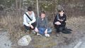
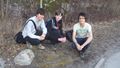
*Reached the hash with [[User:Henrik|Henrik]], Simon och Kristian. -- [[User:zeot|zeot]] 16:49, 12 March 2012 (CET) | *Reached the hash with [[User:Henrik|Henrik]], Simon och Kristian. -- [[User:zeot|zeot]] 16:49, 12 March 2012 (CET) | ||
== Tracklog == | == Tracklog == | ||
<!-- if your GPS device keeps a log, you may post a link here --> | <!-- if your GPS device keeps a log, you may post a link here --> | ||
| + | [http://maps.google.com/maps/ms?msa=0&msid=209560846421673743077.0004bb0af5e7e990adb33 map] of Carl-Johan's walk. | ||
== Photos == | == Photos == | ||
| Line 86: | Line 85: | ||
{{#vardefine:ribbonwidth|800px}} | {{#vardefine:ribbonwidth|800px}} | ||
<!-- Add any achievement ribbons you earned below, or remove this section --> | <!-- Add any achievement ribbons you earned below, or remove this section --> | ||
| + | {{land geohash | latitude = 59 | longitude = 18 | date = 2012-03-12 | name = [[User:Cjk|Carl-Johan]], [[User:Henrik|Henrik]], [[User:Zeot|zeot]], Simon Lindholm, Kristian Alvarez | image = 431436_370440016321556_100000666815091_1155822_483148525_n.jpg }} | ||
| + | {{public transport geohash | latitude = 59 | longitude = 18 | date = 2012-03-12 | name = [[User:Cjk|Carl-Johan]] }} | ||
| + | {{easy geohash | latitude = 59 | longitude = 18 | date = 2012-03-12 | name = [[User:Cjk|Carl-Johan]] }} | ||
Revision as of 21:56, 12 March 2012

| Mon 12 Mar 2012 in 59,18: 59.2660062, 18.0786461 geohashing.info google osm bing/os kml crox |
Location
This hash is located close to a subway station, right next to a small road in a residential area.
Participants
First expedition
Second expedition
Plans
[User:Cjk|Carl-Johan]] saw this on Friday, and it was too easy to pass up. Thought about biking but the pictures would be better if I tried at lunch so by subway was the way to go.
- Thinking of taking the subway there during lunch. -- Carl-Johan 23:19, 11 March 2012 (CET)
Expedition Carl-Johan
My computer at the new work hadn't arrived so I popped out for lunch and grabbed my bag with a can of Orange™ and headed to the subway station. When I get down there it's 9 minutes until the next train in the right directin so i pop up the other exit and grab 2 cheeseburgers at McBlubbers.
Get on the train which takes to Gubbängen which is 350 m from the hash. Walk over there when all of a sudden I see a kitty! Must... pet... Kitty... mind strong... flesh weak....
I tear myself away from the kitty and walk the last 30 meters to the hash. As usual the GPS stops updating just as I have 28.84 m left to the hash. Why oh, why does this always happen. I blame google maps or something. I point the phone to the skies and flip around among programs until I get a signal lock again and it turns out I'm standing on the hash.
- Easy as pie -- Carl-Johan @59.2660,18.0786 12:53, 12 March 2012 (CET)
Mark the dirt with Orange™ even though no one has ever visited my hashes after me. I don't even know why I bother.
Snap some pics and upload them while walking back to the subway and catch the train back to work. Way to easy this one.
Expedition Zeot, Henrik, Simon and Kristian
Tracklog
map of Carl-Johan's walk.
Photos
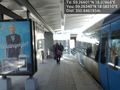
Subway station @59.2634,18.0821
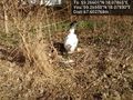
Here kitty @59.2655,18.0793
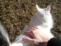
Must... resist... Kitty... powers... @59.2655,18.0793

Grin in the sun @59.2660,18.0786

Easy as pie @59.2660,18.0787
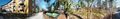
Panorama 1 @59.2648,18.0816
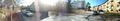
Panorama 2 @59.2715,18.0847
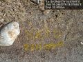
Orange @59.2662,18.0788
Looking mighty fine there

...

Coords
We found that Cjk had tagged the area already, so we stole that and took some pictures.


Achievements
Carl-Johan, Henrik, zeot, Simon Lindholm, Kristian Alvarez earned the Land geohash achievement
|
Carl-Johan earned the Public transport geohash achievement
|
Carl-Johan has visited an Easy Geohash
|