Difference between revisions of "2012-03-18 40 -73"
imported>Sempaispellcheck (→Location) |
imported>FippeBot m (Location) |
||
| (26 intermediate revisions by 3 users not shown) | |||
| Line 1: | Line 1: | ||
| − | |||
| − | |||
| − | |||
| − | |||
| − | |||
| − | |||
| − | |||
| − | |||
| − | |||
| − | |||
{{meetup graticule | {{meetup graticule | ||
| − | | lat= | + | | lat=40 |
| − | | lon= | + | | lon=-73 |
| − | | date= | + | | date=2012-03-18 |
}} | }} | ||
| − | + | [[User:Sempaispellcheck|Sempaispellcheck]]'s FIRST GEOHASH!!, and the first geohash reached in this graticule in 33 months (since [[User:Jevanyn|Jevanyn]] on [[2009-06-05 40 -73|2009-06-05]]). | |
| − | |||
__NOTOC__ | __NOTOC__ | ||
== Location == | == Location == | ||
| − | Nissequoque River Road, Smithtown, Long Island | + | Nissequoque River Road, Smithtown, Long Island. |
It's almost all forest out there, and once you get within about a half-mile of the hash, there are no streetlights. But the trees are awesome, and once you get to the hash, you can see the water. | It's almost all forest out there, and once you get within about a half-mile of the hash, there are no streetlights. But the trees are awesome, and once you get to the hash, you can see the water. | ||
== Participants == | == Participants == | ||
| − | [[User:Sempaispellcheck|Sempaispellcheck]] | + | * [[User:Sempaispellcheck|Sempaispellcheck]] |
== Plans == | == Plans == | ||
| − | + | My plans for this expedition basically went off without a hitch (I just wish the whole thing hadn't taken so much time). See "Expedition" below for more details. | |
== Expedition == | == Expedition == | ||
| − | + | For me to be able to make a geohashing expedition, two things have to happen: | |
| − | + | 1) We have to have a reachable geohash, which is pretty rare since the NYC graticule has so much water in it, and | |
| − | + | 2) I have to have time. Since I am a full-time college student with a work-study job, time is not easy to come by for me | |
| − | == Photos == | + | Today, those two things happened. |
| − | < | + | First, our geohash was on land, and seemed reasonably close to a train station, and |
| − | Image: | + | Second, I had time, given that my place of business closed relatively early (since it was a Sunday) and that I didn't have any homework due tomorrow (today being the last day of Spring Break). |
| − | -- | + | I figured it was now or never. |
| − | + | ||
| + | After work, I took the 7:25 PM LIRR train from Penn Station to Huntington. Transferred at Huntington at 8:36 PM for the train to Port Jefferson, and got off at Smithtown at 9:03. Walked the 2.2 miles from the train station to the hash point - hilly terrain, fairly dark (which makes sense, considering it was a wooded area and about 9:30 PM local time), but paved, which was nice. Saw a house or two every so often, but not many. Got within 2 seconds of the hash point at 9:43 PM, but there was a guardrail there to make sure nobody fell into the water. Took a couple of pictures (not many, and unfortunately the light wasn't good enough for me to capture the water), then walked back to the train station, arriving at 10:21 PM. Took the 10:29 PM train back to Penn Station, arriving at 12:03 AM after an 11:03 PM transfer at Huntington, and went home from there, arriving at 1:00 AM. | ||
| + | |||
| + | I did make two rookie mistakes (it was my first geohash, leave me alone): | ||
| + | 1) I did not bring a marker, and | ||
| + | 2) I did not photograph myself at the hash. | ||
| + | I will not make either of those mistakes again. | ||
| + | |||
| + | == Photos == | ||
| + | <gallery perrow="6"> | ||
| + | Image:2012-03-18 40 -73 geohash.JPG | Challenge accepted. | ||
| + | Image:Me_with_LIRR_receipt.JPG | Proof of Public Transport Geohash Achievement. No idea why it uploaded sideways like that. Anyway, now you know what I look like. Also, the LIRR is expensive. | ||
| + | Image:2012-03-18 40 -73 compass.PNG | Success!! (-2 seconds) | ||
| + | Image:2012-03-18 40 -73 guardrail.JPG | Stupid guardrail. | ||
| + | Image:2012-03-18 40 -73 branches.JPG | Proof of Land Geohash Achievement. I'm sorry you can't see the water through the branches. You really should have been there. | ||
| + | Image:2012-03-18 40 -73 map.PNG | 44 minutes? I can do it in 37. | ||
</gallery> | </gallery> | ||
| Line 44: | Line 48: | ||
<!-- Add any achievement ribbons you earned below, or remove this section --> | <!-- Add any achievement ribbons you earned below, or remove this section --> | ||
| + | {{Land geohash | ||
| + | |||
| + | | latitude = 40 | ||
| + | | longitude = -73 | ||
| + | | date = 2012-03-18 | ||
| + | | name = [[User:Sempaispellcheck|Sempaispellcheck]] | ||
| + | }} | ||
| − | + | {{Public transport geohash | |
| − | |||
| − | |||
| − | + | | latitude = 40 | |
| − | + | | longitude = -73 | |
| − | [[ | + | | date = 2012-03-18 |
| − | + | | name = [[User:Sempaispellcheck|Sempaispellcheck]] | |
| + | | mode of transport = train/subway | ||
| + | }} | ||
| − | |||
[[Category:Expeditions]] | [[Category:Expeditions]] | ||
| − | |||
[[Category:Expeditions with photos]] | [[Category:Expeditions with photos]] | ||
| − | |||
| − | |||
| − | |||
| − | |||
| − | |||
[[Category:Coordinates reached]] | [[Category:Coordinates reached]] | ||
| − | + | {{location|US|NY|SF}} | |
| − | |||
| − | |||
| − | |||
| − | |||
| − | |||
| − | |||
| − | |||
| − | |||
| − | |||
Latest revision as of 03:02, 13 August 2019
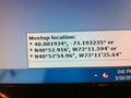
| Sun 18 Mar 2012 in 40,-73: 40.8819343, -73.1932346 geohashing.info google osm bing/os kml crox |
Sempaispellcheck's FIRST GEOHASH!!, and the first geohash reached in this graticule in 33 months (since Jevanyn on 2009-06-05).
Location
Nissequoque River Road, Smithtown, Long Island. It's almost all forest out there, and once you get within about a half-mile of the hash, there are no streetlights. But the trees are awesome, and once you get to the hash, you can see the water.
Participants
Plans
My plans for this expedition basically went off without a hitch (I just wish the whole thing hadn't taken so much time). See "Expedition" below for more details.
Expedition
For me to be able to make a geohashing expedition, two things have to happen:
1) We have to have a reachable geohash, which is pretty rare since the NYC graticule has so much water in it, and 2) I have to have time. Since I am a full-time college student with a work-study job, time is not easy to come by for me
Today, those two things happened. First, our geohash was on land, and seemed reasonably close to a train station, and Second, I had time, given that my place of business closed relatively early (since it was a Sunday) and that I didn't have any homework due tomorrow (today being the last day of Spring Break). I figured it was now or never.
After work, I took the 7:25 PM LIRR train from Penn Station to Huntington. Transferred at Huntington at 8:36 PM for the train to Port Jefferson, and got off at Smithtown at 9:03. Walked the 2.2 miles from the train station to the hash point - hilly terrain, fairly dark (which makes sense, considering it was a wooded area and about 9:30 PM local time), but paved, which was nice. Saw a house or two every so often, but not many. Got within 2 seconds of the hash point at 9:43 PM, but there was a guardrail there to make sure nobody fell into the water. Took a couple of pictures (not many, and unfortunately the light wasn't good enough for me to capture the water), then walked back to the train station, arriving at 10:21 PM. Took the 10:29 PM train back to Penn Station, arriving at 12:03 AM after an 11:03 PM transfer at Huntington, and went home from there, arriving at 1:00 AM.
I did make two rookie mistakes (it was my first geohash, leave me alone): 1) I did not bring a marker, and 2) I did not photograph myself at the hash. I will not make either of those mistakes again.
Photos
Challenge accepted.

Proof of Public Transport Geohash Achievement. No idea why it uploaded sideways like that. Anyway, now you know what I look like. Also, the LIRR is expensive.
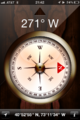
Success!! (-2 seconds)
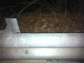
Stupid guardrail.
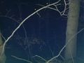
Proof of Land Geohash Achievement. I'm sorry you can't see the water through the branches. You really should have been there.
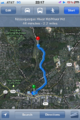
44 minutes? I can do it in 37.


Achievements
Sempaispellcheck earned the Land geohash achievement
|
Sempaispellcheck earned the Public transport geohash achievement
|