Difference between revisions of "2012-03-18 51 11"
imported>TheOneRing |
imported>TheOneRing (→TheOneRing) |
||
| Line 27: | Line 27: | ||
Image:20120318_51_11Me.jpg|...and looking into the Sun | Image:20120318_51_11Me.jpg|...and looking into the Sun | ||
Image:20120318_51_11Car.jpg|Our car | Image:20120318_51_11Car.jpg|Our car | ||
| + | Image:20120318_51_11Surrounding.jpg|Panoramic view over the lake | ||
</gallery> | </gallery> | ||
| − | |||
== Achievements == | == Achievements == | ||
Revision as of 10:47, 1 April 2012
| Sun 18 Mar 2012 in 51,11: 51.8819343, 11.1932346 geohashing.info google osm bing/os kml crox |
Contents
Location
The geohash is at a lake near Westerhausen.
Who went
TheOneRing - by car.
The Expedition
TheOneRing
Once again, I went hiking but this time the geohash was on the way. Furthermore, it was in the region where I was raised so it was some kind of must-have for me.
Fortunately, in the morning the weather was good (in contradiction to the rest of that day) and the geohash was quite easy to reach. It was located at a lake very close to the waterside, which was already to see on the satellite map. This could have been my first Water Geohash. Again, no one else wanted to go with me and I had to walk alone.
After taking the usual photographs and a large panorama across the lake, I continued hiking.
Photos
TheOneRing
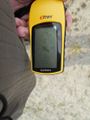
Coordinates reached
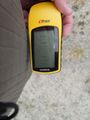
Some additional information
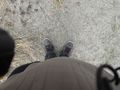
Standing on the geohash...
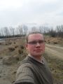
...and looking into the Sun
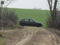
Our car
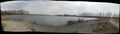
Panoramic view over the lake


Achievements
TheOneRing earned the Land geohash achievement
|