Difference between revisions of "2012-03-19 59 17"
imported>Zeot (→Expedition) |
imported>FippeBot m (Location) |
||
| (5 intermediate revisions by 2 users not shown) | |||
| Line 1: | Line 1: | ||
| − | |||
| − | |||
| − | |||
| − | |||
| − | |||
| − | |||
| − | |||
| − | |||
| − | |||
| − | |||
{{meetup graticule | {{meetup graticule | ||
| lat=59 | | lat=59 | ||
| Line 15: | Line 5: | ||
}} | }} | ||
| − | |||
__NOTOC__ | __NOTOC__ | ||
== Location == | == Location == | ||
| − | + | Some kind of field in Kungsängen. | |
== Participants == | == Participants == | ||
| − | |||
*[[User:zeot|zeot]] | *[[User:zeot|zeot]] | ||
== Plans == | == Plans == | ||
| − | |||
| − | |||
*Shouldn't be too hard. Will go sometime in the late afternoon. -- [[User:Zeot|zeot]] [http://www.openstreetmap.org/?lat=59.31348890&lon=18.05463830&zoom=16&layers=B000FTF @59.3135,18.0546] 17:23, 18 March 2012 (EDT) | *Shouldn't be too hard. Will go sometime in the late afternoon. -- [[User:Zeot|zeot]] [http://www.openstreetmap.org/?lat=59.31348890&lon=18.05463830&zoom=16&layers=B000FTF @59.3135,18.0546] 17:23, 18 March 2012 (EDT) | ||
== Expedition == | == Expedition == | ||
| − | + | Took the commuter train from Stockholm C to Kungsängen and then I started walking towards the hash. It was really windy out so I thought I'd try hitchhiking the last part. The first car passing by stopped, and a really nice woman took me almost all the way to the hash, even though she was going in another direction. The hash was out in some kind of a field, and I'm not sure if they were growing something there or what kind of field it was, but I hope I didn't ruin their crops or something. | |
| − | Took the commuter train from Stockholm C to Kungsängen and then I started walking towards the hash. It was really windy out so I thought I'd try hitchhiking the last part. The first car passing by stopped, and a really nice woman took me almost all the way to the hash, even though she was going in another direction. The hash was out in some kind of a field, and I'm not sure if they were growing something there or what kind of field it was, but I hope I didn't ruin their | ||
| − | |||
| − | |||
| − | |||
== Photos == | == Photos == | ||
| − | |||
| − | |||
| − | |||
<gallery perrow="5"> | <gallery perrow="5"> | ||
| Line 59: | Line 38: | ||
== Achievements == | == Achievements == | ||
{{#vardefine:ribbonwidth|800px}} | {{#vardefine:ribbonwidth|800px}} | ||
| − | + | {{land geohash | |
| − | + | | latitude = 59 | |
| − | + | | longitude = 17 | |
| − | + | | date = 2012-03-19 | |
| − | + | | name = zeot | |
| − | + | }} | |
| + | {{Public transport geohash | ||
| + | | latitude = 59 | ||
| + | | longitude = 17 | ||
| + | | date = 2012-03-19 | ||
| + | | busline = 35 Kungsängen | ||
| + | | name = zeot | ||
| + | }} | ||
| − | |||
| − | |||
| − | |||
| − | |||
| − | |||
| − | |||
[[Category:Expeditions]] | [[Category:Expeditions]] | ||
| − | |||
[[Category:Expeditions with photos]] | [[Category:Expeditions with photos]] | ||
| − | |||
| − | |||
| − | |||
| − | |||
| − | |||
[[Category:Coordinates reached]] | [[Category:Coordinates reached]] | ||
| − | + | {{location|SE|AB}} | |
| − | |||
| − | |||
| − | |||
| − | |||
| − | |||
| − | |||
| − | |||
| − | |||
| − | |||
Latest revision as of 03:03, 13 August 2019
| Mon 19 Mar 2012 in 59,17: 59.4556227, 17.7159722 geohashing.info google osm bing/os kml crox |
Location
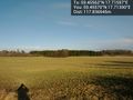
Some kind of field in Kungsängen.
Participants
Plans
- Shouldn't be too hard. Will go sometime in the late afternoon. -- zeot @59.3135,18.0546 17:23, 18 March 2012 (EDT)
Expedition
Took the commuter train from Stockholm C to Kungsängen and then I started walking towards the hash. It was really windy out so I thought I'd try hitchhiking the last part. The first car passing by stopped, and a really nice woman took me almost all the way to the hash, even though she was going in another direction. The hash was out in some kind of a field, and I'm not sure if they were growing something there or what kind of field it was, but I hope I didn't ruin their crops or something.
Photos

On the commuter train @59.3306,18.0543
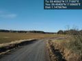
The road to the hash @59.4540,17.6960

At the hash! It's really windy. @59.4556,17.7160

In the car. Thanks for driving me, random nice woman! :) @59.4810,17.7250

Panorama @59.3126,18.0520
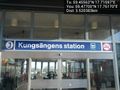
At the train station @59.4770,17.7617
View of the hash from the road @59.4557,17.7139


Achievements
zeot earned the Land geohash achievement
|
zeot earned the Public transport geohash achievement
|