Difference between revisions of "2012-03-20 52 1"
From Geohashing
imported>FippeBot m (Location) |
m |
||
| Line 37: | Line 37: | ||
[[Category:Expeditions]] | [[Category:Expeditions]] | ||
[[Category:Coordinates not reached]] | [[Category:Coordinates not reached]] | ||
| + | [[Category:Not reached - No public access]] | ||
{{location|GB|ENG|NFK}} | {{location|GB|ENG|NFK}} | ||
Latest revision as of 10:24, 16 March 2022
| Tue 20 Mar 2012 in Norwich: 52.4478887, 1.4070098 geohashing.info google osm bing/os kml crox |
Contents
Location
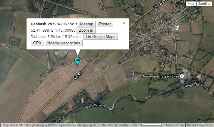
Neil failed to reach the hash in a pig field just off the A143 south west of Bungay, Suffolk, UK.
Participants
Expedition - Fail
The hashpoint was easily within reach and only needed a step over the low electric fence and a few paces into the pig field. After checking the location on the 19th I opted not to proceed for the sake of the biosecurity of the pigs. This was a déjà vu geohash failure duplicating the 2011-11-23 52 1 expedition when the hashpoint was in the very next pig field. This failure was less exciting as it was daylight and quite dry.
Sourcerer earned the No trespassing consolation prize
|
Expeditions and Plans
| 2012-03-20 | ||
|---|---|---|
| Canberra, Australia | 1PE | A cow pasture at Carwoola, ~40km east of Canberra. |
| Atlanta, Georgia | NWoodruff | On a driveway of a house in Avondale Estates |
| Seattle, Washington | OtherJack | Boggy overgrown thorny deciduous woods on an empty lot north of Kenmore |
| München, Germany | Jcbck | 4m into a field from the forest northern boundary |
| Norwich, United Kingdom | Sourcerer | Neil failed to reach the hash in a pig field just off the A143 south west o... |
Sourcerer's Expedition Links
2012-03-19 52 1 - 2012-03-20 52 1 - 2012-04-27 52 1 - KML file download of Sourcerer's expeditions for use with Google Earth.
