Difference between revisions of "2012-03-21 50 8"
imported>JoShi (Created page with "{{subst:Expedition |lat = 50 |lon = 8 |date = 2012-03-21 }}") |
imported>FippeBot m (Location) |
||
| (7 intermediate revisions by 3 users not shown) | |||
| Line 1: | Line 1: | ||
| − | |||
| − | |||
| − | |||
| − | |||
| − | |||
| − | |||
| − | |||
| − | |||
| − | |||
| − | |||
{{meetup graticule | {{meetup graticule | ||
| lat=50 | | lat=50 | ||
| Line 15: | Line 5: | ||
}} | }} | ||
| − | |||
__NOTOC__ | __NOTOC__ | ||
== Location == | == Location == | ||
| − | + | On a meadow near Hattersheim, just out of Frankfurt. | |
== Participants == | == Participants == | ||
| − | + | * [[User:JoShi|JoShi]] | |
| + | * [[User:QuarterCacher|QuarterCacher]] | ||
| − | == | + | == Expedition == |
| − | + | I cycled one way to the geohash (I guess only getting to the hash is required by bike), had lunch in a vietnamese restaurant and returned by public transport as darkness set in. My journey started in F-Eschersheim where I cycled West until I hit the river Nidda which I followed until F Höchst, where it feeds into the Main. I left the Nidda and cycled towards the center of Höchst to get arround the industrial area. From Höchst I was just a short distance to Sindligen and Hattersheim. When I reached the site, I first thought that getting to it was impossible, but cycling along the fence led to a nice opportunity to get to the hash. | |
| − | |||
| − | |||
== Tracklog == | == Tracklog == | ||
| − | + | === JoShi === | |
| + | [[File:2012-03-21-50-08-1.png|200px]] | ||
== Photos == | == Photos == | ||
| − | + | === JoShi === | |
| − | |||
| − | |||
<gallery perrow="5"> | <gallery perrow="5"> | ||
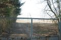
| + | Image:2012-03-21-50-8-4.jpg | Path Blocked | ||
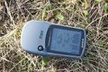
| + | Image:2012-03-21-50-8-5.jpg | Proof | ||
| + | Image:2012-03-21-50-8-6.jpg | Panorama :) | ||
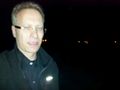
| + | Image:2012-03-21-50-8-7.jpg | Intentional Stupid Look | ||
| + | </gallery> | ||
| + | |||
| + | === QuarterCacher === | ||
| + | <gallery perrow="5"> | ||
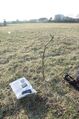
| + | Image:2012-03-21_50_8_21-26-41-023.jpg | Coordinates reached. | ||
</gallery> | </gallery> | ||
| Line 42: | Line 38: | ||
{{#vardefine:ribbonwidth|800px}} | {{#vardefine:ribbonwidth|800px}} | ||
<!-- Add any achievement ribbons you earned below, or remove this section --> | <!-- Add any achievement ribbons you earned below, or remove this section --> | ||
| + | {{Bicycle geohash | ||
| + | | latitude = 50 | ||
| + | | longitude = 8 | ||
| + | | date = 2012-03-21 | ||
| + | | name = JoShi | ||
| + | | distance = 25km | ||
| + | }} | ||
| − | + | {{land geohash | |
| − | |||
| − | |||
| − | + | | latitude = 50 | |
| − | + | | longitude = 8 | |
| − | + | | date = 2012-03-21 | |
| − | + | | name = JoShi and QuarterCacher | |
| + | |||
| + | }} | ||
| − | |||
[[Category:Expeditions]] | [[Category:Expeditions]] | ||
| − | |||
[[Category:Expeditions with photos]] | [[Category:Expeditions with photos]] | ||
| − | |||
| − | |||
| − | |||
| − | |||
| − | |||
[[Category:Coordinates reached]] | [[Category:Coordinates reached]] | ||
| − | + | {{location|DE|HE|MTK}} | |
| − | |||
| − | |||
| − | |||
| − | |||
| − | |||
| − | |||
| − | |||
| − | |||
| − | |||
Latest revision as of 03:05, 13 August 2019
| Wed 21 Mar 2012 in 50,8: 50.0625513, 8.4909986 geohashing.info google osm bing/os kml crox |
Location
On a meadow near Hattersheim, just out of Frankfurt.
Participants
Expedition
I cycled one way to the geohash (I guess only getting to the hash is required by bike), had lunch in a vietnamese restaurant and returned by public transport as darkness set in. My journey started in F-Eschersheim where I cycled West until I hit the river Nidda which I followed until F Höchst, where it feeds into the Main. I left the Nidda and cycled towards the center of Höchst to get arround the industrial area. From Höchst I was just a short distance to Sindligen and Hattersheim. When I reached the site, I first thought that getting to it was impossible, but cycling along the fence led to a nice opportunity to get to the hash.
Tracklog
JoShi

Photos
JoShi
Path Blocked
Proof
Panorama :)

Intentional Stupid Look


QuarterCacher
Coordinates reached.

Achievements
JoShi earned the Bicycle geohash achievement
|
JoShi and QuarterCacher earned the Land geohash achievement
|