Difference between revisions of "2012-03-24 53 -2"
imported>Angel (→Achievements) |
imported>FippeBot m (Location) |
||
| (5 intermediate revisions by 3 users not shown) | |||
| Line 1: | Line 1: | ||
| − | |||
| − | |||
| − | |||
| − | |||
| − | |||
| − | |||
| − | |||
| − | |||
| − | |||
{{meetup graticule | {{meetup graticule | ||
| lat=53 | | lat=53 | ||
| Line 14: | Line 5: | ||
}} | }} | ||
| − | |||
__NOTOC__ | __NOTOC__ | ||
== Location == | == Location == | ||
| Line 28: | Line 18: | ||
== Expedition == | == Expedition == | ||
| − | |||
Expedition in progress; its 3pm now, and I suspect I'll be well late for the meetup. Met a friend on the way who's going by bike, though. So far, I had 3 stops for minor medical emergencies: Low blood sugar, nausea due to dehydration (necessitating a detour to grab more bottled water), and sudden diarrhea (maybe due to spicier-than-usual curry for lunch). I'm still heading there, but may be a bit late. -- [[User:Angel|Angel]] 11:08, 24 March 2012 (EDT) | Expedition in progress; its 3pm now, and I suspect I'll be well late for the meetup. Met a friend on the way who's going by bike, though. So far, I had 3 stops for minor medical emergencies: Low blood sugar, nausea due to dehydration (necessitating a detour to grab more bottled water), and sudden diarrhea (maybe due to spicier-than-usual curry for lunch). I'm still heading there, but may be a bit late. -- [[User:Angel|Angel]] 11:08, 24 March 2012 (EDT) | ||
Jonno made it to the point first; he was on the way back, and we met up again where the path meets the road at about 4:20. Then went back to the hash point, to collaborate on getting some photos of each other. | Jonno made it to the point first; he was on the way back, and we met up again where the path meets the road at about 4:20. Then went back to the hash point, to collaborate on getting some photos of each other. | ||
| + | |||
| + | Good fun first hash for me: a leisurely hour's cycle to the end of the road proper, then a bridleway, then a dirt path, then open moorland - ramping difficulty all the way, in other words. | ||
| + | Glad I made contact with [[User:Angel|Angel]] on the way down (at >30mph down the bridleway): allowed proof to be taken, ''and'' it justified a stop off at the very nice Fleece Inn in Bay Horse nr Dolphinholme. -- [[User:Jonno|Jonno]] 22:56, 25 March 2012 | ||
== Tracklog == | == Tracklog == | ||
| − | + | [http://www.affordable-rpg.co.uk/2012-03-24.gpx Recorded by Cardiotrainer] | |
| − | |||
== Photos == | == Photos == | ||
| − | |||
<gallery perrow="5"> | <gallery perrow="5"> | ||
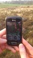
Image:2012-03-24 53 -2 map.png | Screenshot of Geohash Droid; Angel's proof | Image:2012-03-24 53 -2 map.png | Screenshot of Geohash Droid; Angel's proof | ||
| Line 45: | Line 35: | ||
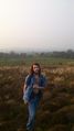
Image:2012-03-24 53 -2 Jonno.jpg | Jonno standing at the hash point | Image:2012-03-24 53 -2 Jonno.jpg | Jonno standing at the hash point | ||
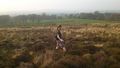
Image:2012-03-24 53 -2 view.jpg | The area where we expect to find a meetup | Image:2012-03-24 53 -2 view.jpg | The area where we expect to find a meetup | ||
| + | Image:hayshawfell.jpg | A panorama from the hash point | ||
</gallery> | </gallery> | ||
== Achievements == | == Achievements == | ||
{{#vardefine:ribbonwidth|800px}} | {{#vardefine:ribbonwidth|800px}} | ||
| − | |||
{{Walk geohash | {{Walk geohash | ||
| latitude = 53 | longitude = -2 | date = 2012-03-24 | name = [[User:Angel|Angel]] | distance = 14.3 miles | image = 2012-03-24 53 -2 Angel.jpg }} | | latitude = 53 | longitude = -2 | date = 2012-03-24 | name = [[User:Angel|Angel]] | distance = 14.3 miles | image = 2012-03-24 53 -2 Angel.jpg }} | ||
| Line 56: | Line 46: | ||
{{Meet-up | {{Meet-up | ||
| latitude = 53 | longitude = -2 | date = 2012-03-24 | name = [[User:Jonno|Jonno]] | other = [[User:Angel|Angel]] }} | | latitude = 53 | longitude = -2 | date = 2012-03-24 | name = [[User:Jonno|Jonno]] | other = [[User:Angel|Angel]] }} | ||
| − | |||
| − | |||
| − | |||
| − | |||
| − | |||
| − | |||
[[Category:Expeditions]] | [[Category:Expeditions]] | ||
[[Category:Expeditions with photos]] | [[Category:Expeditions with photos]] | ||
| − | |||
[[Category:Coordinates reached]] | [[Category:Coordinates reached]] | ||
| + | {{location|GB|ENG|LAN}} | ||
Latest revision as of 03:10, 13 August 2019
| Sat 24 Mar 2012 in 53,-2: 53.9558732, -2.7115310 geohashing.info google osm bing/os kml crox |
Location
Just inside the access area at Hayshaw Fell, just off Long Lane (somewhere south of Bay Horse)
Participants
Plans
Angel's plan: Walk down from Lancaster to Galgate, and then follow the road which seems to lead straight there. See whether or not the location is accessible; it looks like a field on satellite, but it might actually be within the Clougha Access Area. I'm hoping to hit the site some time before 4; if anyone else shows up, we'll retire to the pub in Bay Horse at 4:10.
Expedition
Expedition in progress; its 3pm now, and I suspect I'll be well late for the meetup. Met a friend on the way who's going by bike, though. So far, I had 3 stops for minor medical emergencies: Low blood sugar, nausea due to dehydration (necessitating a detour to grab more bottled water), and sudden diarrhea (maybe due to spicier-than-usual curry for lunch). I'm still heading there, but may be a bit late. -- Angel 11:08, 24 March 2012 (EDT)
Jonno made it to the point first; he was on the way back, and we met up again where the path meets the road at about 4:20. Then went back to the hash point, to collaborate on getting some photos of each other.
Good fun first hash for me: a leisurely hour's cycle to the end of the road proper, then a bridleway, then a dirt path, then open moorland - ramping difficulty all the way, in other words. Glad I made contact with Angel on the way down (at >30mph down the bridleway): allowed proof to be taken, and it justified a stop off at the very nice Fleece Inn in Bay Horse nr Dolphinholme. -- Jonno 22:56, 25 March 2012
Tracklog
Photos
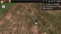
Screenshot of Geohash Droid; Angel's proof
Jonno's GPS
Angel standing at the hash point
Jonno standing at the hash point
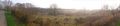
The area where we expect to find a meetup
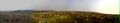
A panorama from the hash point


Achievements
Angel earned the Walk geohash Achievement
|
Jonno earned the Bicycle geohash achievement
|
Jonno earned the Meet-up achievement
|