Difference between revisions of "2012-03-25 55 13"
imported>Relet (→Participants: you can guess better than that. ;)) |
imported>FippeBot m (Location) |
||
| (2 intermediate revisions by one other user not shown) | |||
| Line 1: | Line 1: | ||
| − | + | {{meetup graticule | |
| − | |||
| − | |||
| − | |||
| − | |||
| − | |||
| − | |||
| − | |||
| − | |||
| − | {{meetup graticule | ||
| lat=55 | | lat=55 | ||
| lon=13 | | lon=13 | ||
| Line 14: | Line 5: | ||
}} | }} | ||
| − | + | ||
__NOTOC__ | __NOTOC__ | ||
== Location == | == Location == | ||
| − | + | In a marsh close to Röddinge, Skåne, Sweden | |
| − | |||
| − | |||
== Participants == | == Participants == | ||
| − | + | [[User:Fasanen|Fasanen]] | |
| − | |||
| − | |||
== Plans == | == Plans == | ||
| − | + | Go and have a ball :-) | |
== Expedition == | == Expedition == | ||
| − | + | The rest of the family went to a flea market while I prepared a geohashing pole. I had surveyed the hash to be in a pasturage of some sort in the interesting area of Fyledalen (Fyle valley) which is known for its fauna of bird of pray and interesting flora. During the cold war this also seems to have been some kind if strategic area in order to defend against potentially invading Soviets, so there are some remnants of that to explore. | |
| + | |||
| + | I drove to the hash and parked the car next to the road some 200 meters off target. I met a couple that had been bird watching. We talked a bit about the nice weather before they left. I walked through some nice beech wood and got to the edge of the "pasture". The ground looked nice and firm from a distant but it actually turned out to be marsh and I had to try to get from tussock to tussock which where quite far apart. No Wellingtons today so feet got a bit wet until I reached zero where the geohash pole was planted. | ||
| + | |||
| + | The customary evidence where collected and while going back I tried to take the closest route to get me off the marsh. Back in the beech wood again I took some photographs and listened to woodpeckers hammering away in the trees before returning home on winding country roads. | ||
| + | |||
| + | All in all a nice expedition in a nice area. | ||
| − | |||
| − | |||
== Photos == | == Photos == | ||
| − | + | <gallery perrow="4"> | |
| − | |||
| − | |||
| − | <gallery perrow=" | ||
| − | |||
Image:2012-03-25_55_13_11-28-29-524.jpg | Sent from a swamp [http://www.openstreetmap.org/?lat=55.57244870&lon=13.83774116&zoom=16&layers=B000FTF @55.5724,13.8377] | Image:2012-03-25_55_13_11-28-29-524.jpg | Sent from a swamp [http://www.openstreetmap.org/?lat=55.57244870&lon=13.83774116&zoom=16&layers=B000FTF @55.5724,13.8377] | ||
| + | Image:201203255513_01.png | No fake. I was really there. | ||
| + | Image:201203255513_02.JPG | Smirk | ||
| + | Image:201203255513_03.JPG | The valley | ||
</gallery> | </gallery> | ||
== Achievements == | == Achievements == | ||
{{#vardefine:ribbonwidth|800px}} | {{#vardefine:ribbonwidth|800px}} | ||
| − | + | {{land geohash | latitude=55 | longitude=13 | date=2012-03-25 | name=Fasanen}} | |
| − | |||
| − | |||
| − | |||
| − | |||
| − | |||
| − | |||
| − | |||
| − | |||
[[Category:Expeditions]] | [[Category:Expeditions]] | ||
| − | |||
[[Category:Expeditions with photos]] | [[Category:Expeditions with photos]] | ||
[[Category:Coordinates reached]] | [[Category:Coordinates reached]] | ||
| + | [[Category:Sweden]] | ||
| + | {{location|SE|M}} | ||
Latest revision as of 03:11, 13 August 2019
| Sun 25 Mar 2012 in 55,13: 55.5723902, 13.8377448 geohashing.info google osm bing/os kml crox |
Location
In a marsh close to Röddinge, Skåne, Sweden
Participants
Plans
Go and have a ball :-)
Expedition
The rest of the family went to a flea market while I prepared a geohashing pole. I had surveyed the hash to be in a pasturage of some sort in the interesting area of Fyledalen (Fyle valley) which is known for its fauna of bird of pray and interesting flora. During the cold war this also seems to have been some kind if strategic area in order to defend against potentially invading Soviets, so there are some remnants of that to explore.
I drove to the hash and parked the car next to the road some 200 meters off target. I met a couple that had been bird watching. We talked a bit about the nice weather before they left. I walked through some nice beech wood and got to the edge of the "pasture". The ground looked nice and firm from a distant but it actually turned out to be marsh and I had to try to get from tussock to tussock which where quite far apart. No Wellingtons today so feet got a bit wet until I reached zero where the geohash pole was planted.
The customary evidence where collected and while going back I tried to take the closest route to get me off the marsh. Back in the beech wood again I took some photographs and listened to woodpeckers hammering away in the trees before returning home on winding country roads.
All in all a nice expedition in a nice area.
Photos
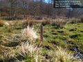
Sent from a swamp @55.5724,13.8377

No fake. I was really there.
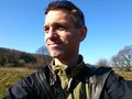
Smirk
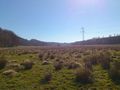
The valley


Achievements
Fasanen earned the Land geohash achievement
|