Difference between revisions of "2012-03-28 -35 149"
From Geohashing
imported>1PE |
imported>JesseW (fix typo, rm New Report and leftover comments) |
||
| Line 1: | Line 1: | ||
| − | |||
| − | |||
| − | |||
| − | |||
| − | |||
| − | |||
| − | |||
| − | |||
| − | |||
{{meetup graticule | {{meetup graticule | ||
| lat=-35 | | lat=-35 | ||
| Line 14: | Line 5: | ||
}} | }} | ||
| − | |||
__NOTOC__ | __NOTOC__ | ||
== Location == | == Location == | ||
| Line 30: | Line 20: | ||
On reflection, I'll '''claim''' this hash: I reached ''the address listed on the [http://activegeohasher.com/geohash/2012-03-28/-35/149 ActiveGeohasher poster]''! | On reflection, I'll '''claim''' this hash: I reached ''the address listed on the [http://activegeohasher.com/geohash/2012-03-28/-35/149 ActiveGeohasher poster]''! | ||
| − | |||
| − | |||
| − | |||
== Photos == | == Photos == | ||
| − | |||
| − | |||
| − | |||
<gallery perrow="5"> | <gallery perrow="5"> | ||
Image:2012-03-28_-35_149.JPG|Me and my doggie mate. | Image:2012-03-28_-35_149.JPG|Me and my doggie mate. | ||
| Line 46: | Line 30: | ||
<!-- Add any achievement ribbons you earned below, or remove this section --> | <!-- Add any achievement ribbons you earned below, or remove this section --> | ||
{{gratuitous ribbon | {{gratuitous ribbon | ||
| − | |||
| color = orange | | color = orange | ||
| icon = Ate_at_myponga.png | | icon = Ate_at_myponga.png | ||
| Line 55: | Line 38: | ||
| description = ... at the gate of the property containing the geohash, meeting their noisy dog (see pic later today)... and the neighbour and her noisy dog, so I got a pic and left the ActiveGeohashing poster and... left! | | description = ... at the gate of the property containing the geohash, meeting their noisy dog (see pic later today)... and the neighbour and her noisy dog, so I got a pic and left the ActiveGeohashing poster and... left! | ||
| name = [[User:1PE|1PE]] | | name = [[User:1PE|1PE]] | ||
| − | |||
}} | }} | ||
| − | |||
| − | |||
| − | |||
| − | |||
| − | |||
| − | |||
| − | |||
| − | |||
| − | |||
| − | |||
| − | |||
[[Category:Expeditions]] | [[Category:Expeditions]] | ||
[[Category:Expeditions with photos]] | [[Category:Expeditions with photos]] | ||
| − | |||
| − | |||
| − | |||
| − | |||
| − | |||
| − | |||
| − | |||
| − | |||
| − | |||
| − | |||
| − | |||
[[Category:Coordinates not reached]] | [[Category:Coordinates not reached]] | ||
[[Category:Not reached - No public access]] | [[Category:Not reached - No public access]] | ||
| − | |||
| − | |||
| − | |||
| − | |||
| − | |||
| − | |||
| − | |||
Revision as of 05:43, 22 May 2012
| Wed 28 Mar 2012 in -35,149: -35.2292002, 149.4668425 geohashing.info google osm bing/os kml crox |
Location
In the rear of a rural property just north of Bungendore, New South Wales, about 35km north-east of Canberra, Australia.
Participants
Plans
Go onto the property and to the dam at the rear.
Expedition
1PE
I did another Lunchtime Launch to this site. There was a woman from the adjoining property in her yard, with her dog. I started to take pictures and the dogs around the area took up the barking/yelping. The dog from 'my' property came to the gate and yelped, too. I got my picture at the gate, left the ActiveGeohasher poster, and left in my car.
On reflection, I'll claim this hash: I reached the address listed on the ActiveGeohasher poster!
Photos
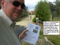
Me and my doggie mate.

Achievements
1PE earned the Nice doggy. Now, shut up!
|