Difference between revisions of "2012-03-28 53 6"
imported>Shevek |
imported>FippeBot m (Location) |
||
| (4 intermediate revisions by 2 users not shown) | |||
| Line 1: | Line 1: | ||
| − | |||
| − | |||
| − | |||
| − | |||
| − | |||
| − | |||
| − | |||
| − | |||
| − | |||
{{meetup graticule | {{meetup graticule | ||
| lat=53 | | lat=53 | ||
| Line 14: | Line 5: | ||
}} | }} | ||
| − | |||
__NOTOC__ | __NOTOC__ | ||
== Location == | == Location == | ||
| Line 20: | Line 10: | ||
== Participants == | == Participants == | ||
| − | [[User:Shevek|Shevek]] | + | * [[User:Shevek|Shevek]] |
| − | Margriet | + | * Margriet |
== Plans == | == Plans == | ||
| Line 40: | Line 30: | ||
== Photos == | == Photos == | ||
| − | + | ||
| − | |||
| − | |||
<gallery perrow="5"> | <gallery perrow="5"> | ||
| + | Image:2012_03_28_53_6_View_from_my_house.jpg|The hash location is over there! | ||
| + | Image:2012_03_28_53_6_entrance.jpg|The gate says no dogs allowed, it doesn't say we can't walk there. | ||
| + | Image:2012_03_28_53_6_meeting.jpg|Yes, we were there! | ||
| + | Image:2012_03_28_53_6_coordinates.jpg|Ok, this didn't really work... | ||
| + | Image:2012_03_28_53_6_juggling1.jpg|Juggling | ||
| + | Image:2012_03_28_53_6_juggling2.jpg|More juggling | ||
| + | Image:2012_03_28_53_6_juggling3.jpg|Even more juggling | ||
| + | Image:2012_03_28_53_6_poster1.jpg|I was here | ||
| + | Image:2012_03_28_53_6_poster2.jpg|So was I | ||
| + | Image:2012_03_28_53_6_poster3.jpg|A nice place to mark our visit, with the hash location in the background | ||
| + | Image:2012_03_28_53_6_park.jpg|On the way back, a swan | ||
</gallery> | </gallery> | ||
== Achievements == | == Achievements == | ||
{{#vardefine:ribbonwidth|800px}} | {{#vardefine:ribbonwidth|800px}} | ||
| − | + | {{land geohash | |
| − | + | | latitude = 53 | |
| − | + | | longitude = 6 | |
| − | + | | date = 2012-03-28 | |
| − | + | | name = [[User:Shevek|Shevek]] | |
| − | [[ | + | | image = 2012_03_28_53_6_meeting.jpg |
| + | }} | ||
| + | {{Bicycle geohash | ||
| + | | latitude = 53 | ||
| + | | longitude = 6 | ||
| + | | date = 2012-03-28 | ||
| + | | name = [[User:Shevek|Shevek]] | ||
| + | | distance = 4 km | ||
| + | | image = 2012_03_28_53_6_entrance.jpg | ||
| + | }} | ||
| + | {{Circus_geohash | ||
| + | | latitude = 53 | ||
| + | | longitude = 6 | ||
| + | | date = 2012-03-28 | ||
| + | | name = [[User:Shevek|Shevek]] | ||
| + | | image = 2012_03_28_53_6_juggling1.jpg | ||
| + | | performance = juggling | ||
| + | }} | ||
| + | {{drag-along | ||
| + | | latitude = 53 | ||
| + | | longitude = 6 | ||
| + | | date = 2012-03-28 | ||
| + | | name = [[User:Shevek|Shevek]] | ||
| + | | partner = Margriet | ||
| + | | image = 2012_03_28_53_6_meeting.jpg | ||
| + | }} | ||
| − | |||
| − | |||
| − | |||
| − | |||
[[Category:Expeditions]] | [[Category:Expeditions]] | ||
| Line 64: | Line 84: | ||
[[Category:Expedition without GPS]] | [[Category:Expedition without GPS]] | ||
[[Category:Coordinates reached]] | [[Category:Coordinates reached]] | ||
| + | {{location|NL|GR}} | ||
Latest revision as of 03:13, 13 August 2019
| Wed 28 Mar 2012 in 53,6: 53.2292002, 6.4668425 geohashing.info google osm bing/os kml crox |
Location
In a field a few kilometers from my house.
Participants
- Shevek
- Margriet
Plans
2012-03-27: Shevek: I intend to be there in the morning. Probably arrive between 8:00 and 9:00. Leave soon again as well, because I don't have all day. I'll try to take some people with me. It's easy enough to find, but I'm not sure about entering the farmland. I think I should go for the ambassador's achievement. :-) Now the question is: who owns that land?
Expedition
7:30: I've taken everything I need, and am going there. At 7:45 I met with Margriet, who said yesterday evening that she would join me. This morning, however, she said she'd never do this again, because getting up so early was terrible.
We cycled the 4 km through the countryside to the hash location. On the way, Margriet woke up and even said that she should do this more often (getting up early). We arrived there so early, that I didn't want to ask people for permission to enter their land; I might wake them up, and I don't think they'd mind us walking onto their grass and off again. So no ambassador for me.
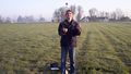
I hadn't tested my gps device except in a car, and I found that it ignores slow movements. So after I switched it on, it told me I was almost there, and then it never changed location again. In short, I had to look at the map and use visual markers (the edges of the field) to determine that I was at the hash. This was actually pretty easy, because it was a small field.
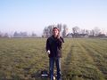
Once we arrived, and determined that we had found the hash, I took out my camera and took a picture. I also tried one of my laptop screen (with xgps showing coordinates), but I mostly photographed my own reflection in the screen, and the letters are unreadable. Ah well, I know I was there. :-)
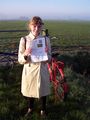
Then I had to do some juggling, and Margriet took pictures of that for proof. And we went back to the road, where we pinned a poster to a nearby tree. Then we had a bit more time than expected, so we went for a short walk in a nearby park. And after that, back home again.
This was a nice little trip. I hope to do one again soon.
Photos
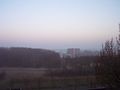
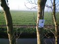
The hash location is over there!
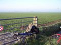
The gate says no dogs allowed, it doesn't say we can't walk there.
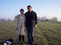
Yes, we were there!
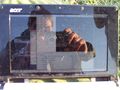
Ok, this didn't really work...
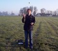
Juggling
More juggling
Even more juggling
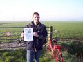
I was here
So was I
A nice place to mark our visit, with the hash location in the background
On the way back, a swan


Achievements
Shevek earned the Land geohash achievement
|
Shevek earned the Bicycle geohash achievement
|
Shevek earned the Circus Geohash Achievement
|
Shevek earned the Drag-along achievement
|