Difference between revisions of "2012-04-01 19 -155"
imported>Simonradford (Created page with "<!-- If you did not specify these parameters in the template, please substitute appropriate values for IMAGE, LAT, LON, and DATE (YYYY-MM-DD format) [[Image:{{{image|IMAGE}}}|t...") |
m (per Renaming Proposal) |
||
| (7 intermediate revisions by 3 users not shown) | |||
| Line 8: | Line 8: | ||
And DON'T FORGET to add your expedition and the best photo you took to the gallery on the Main Page! We'd love to read your report, but that means we first have to discover it! | And DON'T FORGET to add your expedition and the best photo you took to the gallery on the Main Page! We'd love to read your report, but that means we first have to discover it! | ||
--> | --> | ||
| + | |||
{{meetup graticule | {{meetup graticule | ||
| lat=19 | | lat=19 | ||
| Line 31: | Line 32: | ||
== Expedition == | == Expedition == | ||
<!-- how it all turned out. your narrative goes here. --> | <!-- how it all turned out. your narrative goes here. --> | ||
| − | Drove up the Saddle road through the usual east Hawaii drizzle. A nice turnout from the highway led to a jeep track leading off through a (wet) forest growing over an old a'a field. Lots of bird calls. Followed the the track until the GPS showed I was only 40 yards away. Tried bushwhacking to get a bit closer but gave up after only 10 yards or so. The waist high brush obscured the underlying lava boulders, making footing treacherous. And did I say wet? The GPS showed I was there, if you round off to 1 arcsec. | + | Drove up the Saddle road through the usual east Hawaii drizzle. A nice turnout from the highway led to a jeep track leading off through a (wet) forest growing over an old 'a'a field. Lots of bird calls. Followed the the track until the GPS showed I was only 40 yards away. Tried bushwhacking to get a bit closer but gave up after only 10 yards or so. The waist high brush obscured the underlying lava boulders, making footing treacherous. And did I say wet? The GPS showed I was there, if you round off to 1 arcsec. |
== Tracklog == | == Tracklog == | ||
| Line 41: | Line 42: | ||
<gallery perrow="5"> | <gallery perrow="5"> | ||
Image:2012-04_01_19_-155-a.jpg | Jeep track through the forest. | Image:2012-04_01_19_-155-a.jpg | Jeep track through the forest. | ||
| − | Image:2012- | + | Image:2012-04_01_19_-155-b.jpg | Wet, impenetrable forest. |
| − | Image:2012- | + | Image:2012-04_01_19_-155-c.jpg | You can (just) read the GPS coordinates. |
| − | Image:2012- | + | Image:2012-04_01_19_-155-d.jpg | I have arrived. |
</gallery> | </gallery> | ||
| Line 51: | Line 52: | ||
| − | {{ | + | {{Graticule unlocked |
| latitude = 19 | | latitude = 19 | ||
| longitude = -155 | | longitude = -155 | ||
| Line 65: | Line 66: | ||
}} | }} | ||
| − | + | {{West Geohash | |
| − | + | | latitude = 19 | |
| − | + | | longitude = -155 | |
| − | + | | date = 2012-04-01 | |
| − | + | | name = [[User:Simonradford|Simon]] | |
| − | + | }} | |
| − | |||
| − | |||
| − | |||
| − | |||
| − | [[ | ||
| − | |||
| − | |||
[[Category:Expeditions]] | [[Category:Expeditions]] | ||
| − | |||
[[Category:Expeditions with photos]] | [[Category:Expeditions with photos]] | ||
| − | |||
| − | |||
| − | |||
| − | |||
| − | |||
[[Category:Coordinates reached]] | [[Category:Coordinates reached]] | ||
| − | + | {{location|US|HI|HA}} | |
| − | |||
| − | |||
| − | |||
| − | |||
| − | |||
| − | |||
| − | |||
| − | |||
| − | |||
Latest revision as of 05:42, 20 March 2024
| Sun 1 Apr 2012 in 19,-155: 19.6803372, -155.2810392 geohashing.info google osm bing/os kml crox |
Location
In a (wet and impenetrable) forest in the Saddle between Mauna Loa and Mauna Kea. A mile or so from the highway just off a jeep track.
Participants
Plans
No plans. Spontaneity rules.
Expedition
Drove up the Saddle road through the usual east Hawaii drizzle. A nice turnout from the highway led to a jeep track leading off through a (wet) forest growing over an old 'a'a field. Lots of bird calls. Followed the the track until the GPS showed I was only 40 yards away. Tried bushwhacking to get a bit closer but gave up after only 10 yards or so. The waist high brush obscured the underlying lava boulders, making footing treacherous. And did I say wet? The GPS showed I was there, if you round off to 1 arcsec.
Tracklog
Photos
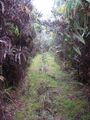
Jeep track through the forest.
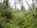
Wet, impenetrable forest.
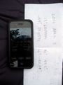
You can (just) read the GPS coordinates.

I have arrived.


Achievements
Simon earned the Graticule Unlocked Achievement
|
Simon earned the Land geohash achievement
|
Simon earned the West geohash achievement
|