Difference between revisions of "2012-04-02 48 11"
From Geohashing
imported>Chrisp (→Photos) |
imported>FippeBot m (Location) |
||
| (6 intermediate revisions by 2 users not shown) | |||
| Line 1: | Line 1: | ||
| − | |||
<!-- If you did not specify these parameters in the template, please substitute appropriate values for IMAGE, LAT, LON, and DATE (YYYY-MM-DD format) | <!-- If you did not specify these parameters in the template, please substitute appropriate values for IMAGE, LAT, LON, and DATE (YYYY-MM-DD format) | ||
| Line 15: | Line 14: | ||
}} | }} | ||
| − | |||
__NOTOC__ | __NOTOC__ | ||
== Location == | == Location == | ||
| − | + | ||
In a field near the Munich airport | In a field near the Munich airport | ||
== Participants == | == Participants == | ||
| − | |||
| − | + | * [[User:Chrisp|Chrisp]] | |
| − | |||
== Expedition == | == Expedition == | ||
| − | |||
| − | + | My first hash. | |
| − | + | ||
| + | It was a nice day, I wanted to go biking, and always wanted to try Geohashing. So I combined these things and showed up at an easy-to-access location in a field near the Munich airport. | ||
== Photos == | == Photos == | ||
| − | + | ||
| − | + | ||
| − | |||
<gallery perrow="5"> | <gallery perrow="5"> | ||
File:2012-04-02_48_11-01.JPG|View of the airport at the location | File:2012-04-02_48_11-01.JPG|View of the airport at the location | ||
| Line 47: | Line 42: | ||
<!-- Add any achievement ribbons you earned below, or remove this section --> | <!-- Add any achievement ribbons you earned below, or remove this section --> | ||
| + | * Land Geohash | ||
| + | * Bike Geohash | ||
| − | |||
| − | |||
| − | |||
| − | |||
| − | |||
| − | |||
| − | |||
| − | |||
| − | |||
[[Category:Expeditions]] | [[Category:Expeditions]] | ||
| − | |||
[[Category:Expeditions with photos]] | [[Category:Expeditions with photos]] | ||
| − | |||
| − | |||
| − | |||
| − | |||
| − | |||
[[Category:Coordinates reached]] | [[Category:Coordinates reached]] | ||
| − | + | {{location|DE|BY|FS}} | |
| − | |||
| − | |||
| − | |||
| − | |||
| − | |||
| − | |||
| − | |||
| − | |||
| − | |||
Latest revision as of 03:17, 13 August 2019
| Mon 2 Apr 2012 in 48,11: 48.3651944, 11.7465287 geohashing.info google osm bing/os kml crox |
Location
In a field near the Munich airport
Participants
Expedition
My first hash.
It was a nice day, I wanted to go biking, and always wanted to try Geohashing. So I combined these things and showed up at an easy-to-access location in a field near the Munich airport.
Photos
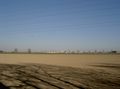
View of the airport at the location
Marker at the location

I was there too :)


Achievements
- Land Geohash
- Bike Geohash