Difference between revisions of "2012-04-05 -35 149"
From Geohashing
imported>FippeBot m (Location) |
m (More specific location) |
||
| Line 31: | Line 31: | ||
[[Category:Not reached - No public access]] | [[Category:Not reached - No public access]] | ||
[[Category:Expedition without GPS]] | [[Category:Expedition without GPS]] | ||
| − | {{location|AU|NSW}} | + | {{location|AU|NSW|QB}} |
Latest revision as of 12:15, 1 August 2020

| Thu 5 Apr 2012 in -35,149: -35.4048311, 149.2127302 geohashing.info google osm bing/os kml crox |
Location
Along a fence line south of the Queanbeyan Quarry, off Old Cooma Road.
Participants
Plans
Get there after a meeting in Queanbeyan during the afternoon.
Expedition
1PE
The address on the roadside mail boxes bore no relationship to the supposed address. I navigated by road turns and landmarks. The gravel track had recently been re-graded and there were sharp stones, so I drove carefully on my 'road' tyres. At the expcted kink in the road I was able to stop beside a substantial gate with the fence disappearing at right angles. There were regular signs saying QUARRY SITE KEEP OUT. So, I went no further, fixed the ActiveGeohasher poster beside the gate, took my pictures, and left.
Photos
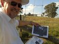
I am not a quarryman.
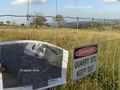
So, I kept out.
