Difference between revisions of "2012-04-07 45 -93"
imported>Zdavkeos (→Participants) |
imported>Zdavkeos m |
||
| Line 55: | Line 55: | ||
| latitude = 45 | | latitude = 45 | ||
| longitude = -93 | | longitude = -93 | ||
| − | | date = 2012-04- | + | | date = 2012-04-07 |
| name = Zach | | name = Zach | ||
| image = 2012-04-07_45_-93_Zach.jpg | | image = 2012-04-07_45_-93_Zach.jpg | ||
Revision as of 17:38, 8 April 2012
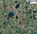
| Sat 7 Apr 2012 in 45,-93: 45.1885982, -93.8898827 geohashing.info google osm bing/os kml crox |
Location
On the shoulder of County Road 12 N in Buffalo, MN
Participants
My girlfriend Brooke and I
Plans
Leisurely drive on a Saturday afternoon up to Buffalo, MN.
Expedition
We were busy early in the day but managed to take off around 5pm from Plymouth. W reached the spot along the road a half hour later. We parked in a field inlet and walked down the road to the exact spot. When surveying the spot from google maps, it didn't look like there was much there, but there has been a lot of construction and the subdivision across the road is pretty built up! A fun trip even if Brooke did sleep the whole way there ;).
Tracklog
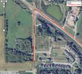
I really wanted to have proof this time, so I used MyTracks on Android to trace our path. I included a couple of screen shots below.
Photos
GPS Track
GPS Track up close

Standing on the spot. Some scrub ground behind me

Brooke and I


Achievements
Zach earned the Land geohash achievement
|