Difference between revisions of "2012-04-09 48 11"
imported>Zertrin (Creation of the expedition page) |
imported>FippeBot m (Location) |
||
| (4 intermediate revisions by one other user not shown) | |||
| Line 1: | Line 1: | ||
| − | |||
<!-- If you did not specify these parameters in the template, please substitute appropriate values for IMAGE, LAT, LON, and DATE (YYYY-MM-DD format) | <!-- If you did not specify these parameters in the template, please substitute appropriate values for IMAGE, LAT, LON, and DATE (YYYY-MM-DD format) | ||
| Line 18: | Line 17: | ||
__NOTOC__ | __NOTOC__ | ||
== Location == | == Location == | ||
| − | + | In front of the entry to a small commercial area, in Pasing-Obermenzing, west of München. | |
== Participants == | == Participants == | ||
| − | + | [[User:Zertrin|Zertrin]] | |
== Plans == | == Plans == | ||
| Line 27: | Line 26: | ||
== Expedition == | == Expedition == | ||
| − | + | My first hash :) | |
| + | |||
| + | I've been looking for some time after a suitable hash near Munich to begin my geohashing experience. Today was a good candidate as it could be quite easily reached by bike from where I live. The weather was promising on the beginning of the afternoon, but as I began heading to the hash by bike it began to be very cloudy with some droplets in the air. It hasn't really rained, although it was quite cold with wind and droplets, and I made it to the hash at approx. 4:45 p.m. and stayed there until 5:10 p.m. in case another geohasher who would have read the München graticule page had seen my intention to be there at 5 p.m. | ||
== Tracklog == | == Tracklog == | ||
| Line 37: | Line 38: | ||
--> | --> | ||
<gallery perrow="5"> | <gallery perrow="5"> | ||
| + | Image:Geohash for 2012-04-09 48 11.JPG | Position of the hash as seen by Google Maps Satellite view | ||
| + | Image:GPS coord hash 2012-04-09 48 11.JPG | My GPS app showing my position. Very bad accuracy but I can't afford yet a true GPS device... | ||
| + | Image:Zertrin at hash 2012-04-09 48 11.JPG | Me and my bike at hash location | ||
| + | Image:Commercial area hash 2012-04-09 48 11.JPG | View of the entry of the commercial area. Hash location is where my bike stand. | ||
| + | Image:Typical bavarian maypole in front of hash location 2012-09-04 48 11.JPG | Typical bavarian [http://en.wikipedia.org/wiki/Maypole maypole] in front of hash location | ||
</gallery> | </gallery> | ||
== Achievements == | == Achievements == | ||
{{#vardefine:ribbonwidth|800px}} | {{#vardefine:ribbonwidth|800px}} | ||
| − | + | {{Bicycle geohash | latitude = 48 | longitude = 11 | date = 2012-04-09 | name = Zertrin | distance = 13 km | image = Zertrin_at_hash_2012-04-09_48_11.JPG }} | |
<!-- =============== USEFUL CATEGORIES FOLLOW ================ | <!-- =============== USEFUL CATEGORIES FOLLOW ================ | ||
Delete the next line ONLY if you have chosen the appropriate categories below. If you are unsure, don't worry. People will read your report and help you with the classification. --> | Delete the next line ONLY if you have chosen the appropriate categories below. If you are unsure, don't worry. People will read your report and help you with the classification. --> | ||
| − | |||
| − | |||
| − | |||
| − | |||
| − | |||
| − | |||
| − | |||
[[Category:Expeditions]] | [[Category:Expeditions]] | ||
| − | |||
[[Category:Expeditions with photos]] | [[Category:Expeditions with photos]] | ||
| − | + | ||
| − | |||
| − | |||
| − | |||
| − | |||
[[Category:Coordinates reached]] | [[Category:Coordinates reached]] | ||
| − | + | {{location|DE|BY|M|city=true}} | |
| − | |||
| − | |||
| − | |||
| − | |||
| − | |||
| − | |||
| − | |||
| − | |||
| − | |||
Latest revision as of 03:25, 13 August 2019
| Mon 9 Apr 2012 in 48,11: 48.1494111, 11.4347079 geohashing.info google osm bing/os kml crox |
Location
In front of the entry to a small commercial area, in Pasing-Obermenzing, west of München.
Participants
Plans
Expedition
My first hash :)
I've been looking for some time after a suitable hash near Munich to begin my geohashing experience. Today was a good candidate as it could be quite easily reached by bike from where I live. The weather was promising on the beginning of the afternoon, but as I began heading to the hash by bike it began to be very cloudy with some droplets in the air. It hasn't really rained, although it was quite cold with wind and droplets, and I made it to the hash at approx. 4:45 p.m. and stayed there until 5:10 p.m. in case another geohasher who would have read the München graticule page had seen my intention to be there at 5 p.m.
Tracklog
Photos
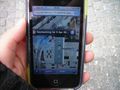
Position of the hash as seen by Google Maps Satellite view
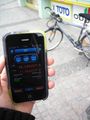
My GPS app showing my position. Very bad accuracy but I can't afford yet a true GPS device...
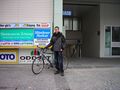
Me and my bike at hash location
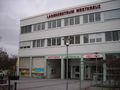
View of the entry of the commercial area. Hash location is where my bike stand.
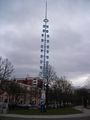
Typical bavarian maypole in front of hash location


Achievements
Zertrin earned the Bicycle geohash achievement
|