Difference between revisions of "2012-04-09 53 6"
imported>Shevek |
imported>FippeBot m (Location) |
||
| (14 intermediate revisions by 3 users not shown) | |||
| Line 1: | Line 1: | ||
| − | |||
| − | |||
| − | |||
| − | |||
| − | |||
| − | |||
| − | |||
| − | |||
| − | |||
{{meetup graticule | {{meetup graticule | ||
| lat=53 | | lat=53 | ||
| Line 14: | Line 5: | ||
}} | }} | ||
| − | |||
__NOTOC__ | __NOTOC__ | ||
== Location == | == Location == | ||
| Line 20: | Line 10: | ||
== Participants == | == Participants == | ||
| − | [[User:Shevek|Shevek]] and | + | [[User:Shevek|Shevek]] and [[User:Reyes|Reyes]] |
== Plans == | == Plans == | ||
| Line 38: | Line 28: | ||
After the hash, we went to a nearby geocache. We had thought about doing another cache, which is a walk in the forest, but due to the rain that had started, we skipped that. | After the hash, we went to a nearby geocache. We had thought about doing another cache, which is a walk in the forest, but due to the rain that had started, we skipped that. | ||
| + | |||
| + | |||
| + | === [[User:Reyes|Reyes]] === | ||
| + | This was the first time I went geohashing and I had a rather tough time getting to the hash, because of the wind, but I managed, and so did Bas with his very cool bike (see photos). It was a pity we didn't have to climb on anything but maybe that will be needed next time. We couldn't find the exact spot of the hash, but came very close. At some point it started to rain, so we had to come up with something to keep the 'the internet was here'-paper dry. Luckily, I had just eaten my 'krentenbol' - apparently the word in English is 'curran bun', but it sounds weird - so we used the plastic packaging (see photo). On the way back we biked to a cache and found it very quickly. Unfortunately, we missed someone who was there 40 minutes before. Then we biked all the way back to Bas' apartment, where I had to dry my socks, shoes, coat and cardigan. Next time I will choose different clothing. Leather shoes and a rain coat are quite useful during a wet trip like this. | ||
| + | I had a great time during my first geohashing-experience (well, not the biking in the wind part) and hope to do it again soon. | ||
== Photos == | == Photos == | ||
| − | |||
| − | |||
| − | |||
| − | |||
<gallery perrow="5"> | <gallery perrow="5"> | ||
| + | Image:2012_04_09_53_6_solution.jpg|Just keep turning those pedals... | ||
| + | Image:2012_04_09_53_6_us.jpg|We've arrived! | ||
| + | Image:2012_04_09_53_6_screenshot.png|The proof that we were at least almost there | ||
| + | Image:2012_04_09_53_6_marker.jpg|The poster with the plastic bag protection | ||
| + | Image:2012_04_09_53_6_memarker.jpg|Shevek next to the marker | ||
</gallery> | </gallery> | ||
== Achievements == | == Achievements == | ||
| − | |||
{{#vardefine:ribbonwidth|800px}} | {{#vardefine:ribbonwidth|800px}} | ||
<!-- Add any achievement ribbons you earned below, or remove this section --> | <!-- Add any achievement ribbons you earned below, or remove this section --> | ||
| + | {{drag-along | ||
| + | | latitude = 53 | ||
| + | | longitude = 6 | ||
| + | | date = 2012-04-09 | ||
| + | | name = [[User:Shevek|Shevek]] | ||
| + | | partner = [[User:Reyes|Reyes]] | ||
| + | | image = 2012_04_09_53_6_us.jpg | ||
| + | }} | ||
| + | {{land geohash | ||
| + | | latitude = 53 | ||
| + | | longitude = 6 | ||
| + | | date = 2012-04-09 | ||
| + | | name = [[User:Shevek|Shevek]] and [[User:Reyes|Reyes]] | ||
| + | | image = 2012_04_09_53_6_memarker.jpg | ||
| + | }} | ||
| + | {{Bicycle geohash | ||
| + | | latitude = 53 | ||
| + | | longitude = 6 | ||
| + | | date = 2012-04-09 | ||
| + | | name = [[User:Shevek|Shevek]] | ||
| + | | distance = 24 km | ||
| + | | image = 2012_04_09_53_6_solution.jpg | ||
| + | }} | ||
| + | {{Bicycle geohash | ||
| + | | latitude = 53 | ||
| + | | longitude = 6 | ||
| + | | date = 2012-04-09 | ||
| + | | name = [[User:Reyes|Reyes]] | ||
| + | | distance = 17 km | ||
| + | }} | ||
| + | {{Public transport geohash | ||
| + | | latitude = 53 | ||
| + | | longitude = 6 | ||
| + | | date = 2012-04-09 | ||
| + | | name = [[User:Reyes|Reyes]] | ||
| + | | busline = train from Hoogezand to Groningen | ||
| + | }} | ||
| − | |||
| − | |||
| − | |||
| − | |||
| − | |||
| − | |||
[[Category:Expeditions]] | [[Category:Expeditions]] | ||
[[Category:Expeditions with photos]] | [[Category:Expeditions with photos]] | ||
| − | |||
[[Category:Coordinates reached]] | [[Category:Coordinates reached]] | ||
| + | [[Category:Shevek]] | ||
| + | {{location|NL|DR}} | ||
Latest revision as of 03:27, 13 August 2019
| Mon 9 Apr 2012 in 53,6: 53.1494111, 6.4347079 geohashing.info google osm bing/os kml crox |
Location
The hash is on a street in Roden, so once you're there, it's easy to reach it. No special permissions or climbing required.
Participants
Plans
I have quite a busy day, so I'm not sure if I'll make it. I hope to go there by scooter, so I can get the speed racer achievement (I suppose the maximum speed is 30 km/h). If I happen to have a lot of time, I might go by bike, but I don't think so.
I've found a friend willing to join me, we'll cycle there together. I'm still hoping to make the speedracer achievement. :-) We'll probably be there around 15:00.
Expedition
Shevek
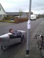
I had to go to the store, and the only one open on this easter monday was in the wrong direction, but close to where Loni would arrive by train. So I first went there and picked her up. Together we first went to the store, which wouldn't open until 16:00. Ah well. So we went to the hash by bike. I had taken my Alleweder trike (see photos), which is great for cycling against the wind, but city-builders don't expect it, so it's not always possible to pass though places which are intended for normal bikes. (See photo). With some effort, I managed to cycle down and up the stairs. I also passed shallow paths with only one front wheel on the path. Still, Loni had a much harder time than I, because we had a strong wind against us. She, too, made it without complaining, though.
At the hash location, I took out my gps unit, which is my laptop. Unfortunately, it doesn't change its value if it's moving slowly (walking speed), so it's hard to get it to exactly the right coordinates. But since we walked all over the place, I'm sure we have been at the hash. The screenshot shows coordinates which are really close.
Unfortunately it wasn't a 30 km/h zone, so the maximum speed was 50 km/h. I can go quite fast on my bike, but not that fast...
After the hash, we went to a nearby geocache. We had thought about doing another cache, which is a walk in the forest, but due to the rain that had started, we skipped that.
Reyes
This was the first time I went geohashing and I had a rather tough time getting to the hash, because of the wind, but I managed, and so did Bas with his very cool bike (see photos). It was a pity we didn't have to climb on anything but maybe that will be needed next time. We couldn't find the exact spot of the hash, but came very close. At some point it started to rain, so we had to come up with something to keep the 'the internet was here'-paper dry. Luckily, I had just eaten my 'krentenbol' - apparently the word in English is 'curran bun', but it sounds weird - so we used the plastic packaging (see photo). On the way back we biked to a cache and found it very quickly. Unfortunately, we missed someone who was there 40 minutes before. Then we biked all the way back to Bas' apartment, where I had to dry my socks, shoes, coat and cardigan. Next time I will choose different clothing. Leather shoes and a rain coat are quite useful during a wet trip like this. I had a great time during my first geohashing-experience (well, not the biking in the wind part) and hope to do it again soon.
Photos
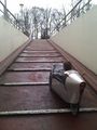
Just keep turning those pedals...
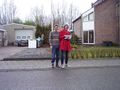
We've arrived!
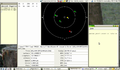
The proof that we were at least almost there
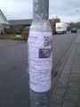
The poster with the plastic bag protection
Shevek next to the marker


Achievements
Shevek earned the Drag-along achievement
|
Shevek and Reyes earned the Land geohash achievement
|
Shevek earned the Bicycle geohash achievement
|
Reyes earned the Bicycle geohash achievement
|
Reyes earned the Public transport geohash achievement
|