Difference between revisions of "2012-04-27 33 -111"
imported>Ecnelis (added photos) |
imported>Ecnelis |
||
| Line 39: | Line 39: | ||
Image:2010-##-## ## ## Alpha.jpg | Witty Comment | Image:2010-##-## ## ## Alpha.jpg | Witty Comment | ||
--> | --> | ||
| + | |||
<gallery> | <gallery> | ||
Image:2012-04-27_33_-111_17-21-09-444.jpg | Look what we found at our hangout today! [http://www.openstreetmap.org/?lat=33.55852410&lon=-111.86522041&zoom=16&layers=B000FTF @33.5585,-111.8652] | Image:2012-04-27_33_-111_17-21-09-444.jpg | Look what we found at our hangout today! [http://www.openstreetmap.org/?lat=33.55852410&lon=-111.86522041&zoom=16&layers=B000FTF @33.5585,-111.8652] | ||
| Line 44: | Line 45: | ||
Image:Foal_looking_on.JPG | Just a wee baby! | Image:Foal_looking_on.JPG | Just a wee baby! | ||
</gallery> | </gallery> | ||
| − | |||
| − | |||
| − | |||
| − | |||
| − | |||
| − | |||
| − | |||
| − | |||
| − | |||
| − | |||
| − | |||
== Achievements == | == Achievements == | ||
| Line 75: | Line 65: | ||
[[Category:New report]] | [[Category:New report]] | ||
| − | |||
| − | |||
| − | |||
| − | |||
| − | |||
[[Category:Expeditions]] | [[Category:Expeditions]] | ||
| − | |||
| − | |||
| − | |||
| − | |||
| − | |||
[[Category:Expeditions with photos]] | [[Category:Expeditions with photos]] | ||
| − | |||
| − | |||
| − | |||
| − | |||
| − | |||
| − | |||
| − | |||
| − | |||
| − | |||
| − | |||
| − | |||
| − | |||
| − | |||
[[Category:Not reached - Mother Nature]] | [[Category:Not reached - Mother Nature]] | ||
[[Category:Not reached - No public access]] | [[Category:Not reached - No public access]] | ||
| + | |||
| + | [[Category: Meetup on 2012-04-27]] | ||
| + | [[Category: Meetup in 33 -111]] | ||
Revision as of 02:25, 28 April 2012
| Fri 27 Apr 2012 in 33,-111: 33.5585748, -111.8650723 geohashing.info google osm bing/os kml crox |
Location
Next to a golf course right off the freeway. ooOOoo
Participants
Karina - doesn't have her profile yet... slacker
Plans
Should be arriving sometime in the late afternoon. It's in the middle of the desert... In Arizona... At the start of summer... HOT!
Expedition
Well, that was an adventure. The street was blocked off, so we had to park on the side of the road, jump the road block, and then traverse through the desert.
We stumbled upon some wild(ish) horses. As you can see from the picture, we stopped short of our destination. The reason for this is we didn't want to startle the horses, and the final location was pretty much exactly where the horses were hanging out.
So, all in all, we got to hangout with a few wild horses... Awesome!
A great first GeoHashing if you ask me!
Photos
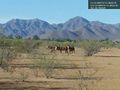
Look what we found at our hangout today! @33.5585,-111.8652
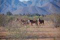
Visitors that decided to join us
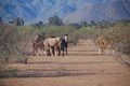
Just a wee baby!


Achievements
Ecnelis earned the Land geohash achievement
|