Difference between revisions of "2012-04-28 50 8"
imported>Mampfred (Created page with "{{subst:Expedition |lat = 50 |lon = 8 |date = 2012-04-28 }}") |
imported>FippeBot m (Location) |
||
| (2 intermediate revisions by one other user not shown) | |||
| Line 1: | Line 1: | ||
| − | |||
| − | |||
| − | |||
| − | |||
| − | |||
{{meetup graticule | {{meetup graticule | ||
| lat=50 | | lat=50 | ||
| Line 10: | Line 5: | ||
}} | }} | ||
| − | |||
__NOTOC__ | __NOTOC__ | ||
== Location == | == Location == | ||
| − | + | In the woods behind Gräveneck. | |
== Participants == | == Participants == | ||
| − | + | * [[User:Mampfred|Mampfred]] | |
| − | + | * [[User:LadyBB|LadyBB]] | |
| + | * [[User:EmmJay|EmmJay]] | ||
== Plans == | == Plans == | ||
| − | + | We're on our way to Wetzlar tomorrow and will take a little detour to get the hash before noon. | |
== Expedition == | == Expedition == | ||
| − | + | What a beautiful day for hashing that was :) | |
| + | |||
| + | Found the parking spot without problem but it was a no parking zone due to a bus station and buses using it as a turn around area. We checked the timetable though and the next bus on a saturday wouldn't come in for another hour or so, so we parked there anyways. | ||
| + | |||
| + | Behind us was a little bridge across the Lahn river. In fact, the hash would be right next to the river as well which at this point didn't bother us at all. | ||
| + | |||
| + | Taking the path to the hash though we realized that there would be a vers steep drop towards the river going forward. Be the time the hash came close, it was a good 10 meters straight down - not great if you have a child with you. | ||
| + | |||
| + | Luckily, we didn't give up and around the next bend there was a well walked path going down right to the hash. | ||
| + | |||
| + | The area seems to be an abandoned mining something-or-the-other but we didn't investigate any further. | ||
| + | |||
| + | Coordinates reached, hashers happy :) | ||
== Tracklog == | == Tracklog == | ||
| − | + | See [http://www.everytrail.com/view_trip.php?trip_id=1550292 here]. | |
== Photos == | == Photos == | ||
| − | |||
| − | |||
| − | |||
<gallery perrow="5"> | <gallery perrow="5"> | ||
| + | Image:2012-04-28_50_8_parking.jpg | No parking. But if you stand close enough to the sign, you can't see it, right? | ||
| + | Image:2012-04-28_50_8_bridge_over_lahn.jpg | Parking with a view. | ||
| + | Image:2012-04-28_50_8_down_theresomwhere_2.jpg | Hmm, that's too steep ... | ||
| + | Image:2012-04-28_50_8_around_this_corner.jpg | OK, let's try around this corner. | ||
| + | Image:2012-04-28_50_8_down_this_path.jpg | Yep, that should be the way. | ||
| + | Image:2012-04-28_50_8_stollen_on_the_way.jpg | Abandoned mining tunnels? | ||
| + | Image:2012-04-28_50_8_hash_trash.jpg | Abandoned mining trash? | ||
| + | Image:2012-04-28_50_8_green_rubble.jpg | Lots of green rubble near the hash. | ||
| + | Image:2012-04-28_50_8_hash_dance_with_child.jpg | Hash dance with child. | ||
| + | Image:2012-04-28_50_8_coordinates_reached.jpg | Coordinates reached. | ||
| + | Image:2012-04-28_50_8_that_was_the_best_shot_....jpg | Stupid grin. | ||
| + | Image:2012-04-28_50_8_shortcut_going_up.jpg | There was also this shortcut which we didn't see from above. | ||
</gallery> | </gallery> | ||
== Achievements == | == Achievements == | ||
{{#vardefine:ribbonwidth|800px}} | {{#vardefine:ribbonwidth|800px}} | ||
| − | + | * Land | |
| − | |||
| − | |||
| − | |||
| − | |||
| − | |||
| − | |||
| − | |||
| − | |||
| − | |||
| − | |||
| − | |||
[[Category:Expeditions]] | [[Category:Expeditions]] | ||
| − | |||
[[Category:Expeditions with photos]] | [[Category:Expeditions with photos]] | ||
| − | |||
| − | |||
| − | |||
| − | |||
| − | |||
[[Category:Coordinates reached]] | [[Category:Coordinates reached]] | ||
| − | + | {{location|DE|HE|LM}} | |
| − | |||
| − | |||
| − | |||
| − | |||
| − | |||
| − | |||
| − | |||
| − | |||
| − | |||
Latest revision as of 03:42, 13 August 2019
| Sat 28 Apr 2012 in 50,8: 50.4519755, 8.2477861 geohashing.info google osm bing/os kml crox |
Location
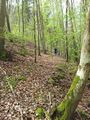
In the woods behind Gräveneck.
Participants
Plans
We're on our way to Wetzlar tomorrow and will take a little detour to get the hash before noon.
Expedition
What a beautiful day for hashing that was :)
Found the parking spot without problem but it was a no parking zone due to a bus station and buses using it as a turn around area. We checked the timetable though and the next bus on a saturday wouldn't come in for another hour or so, so we parked there anyways.
Behind us was a little bridge across the Lahn river. In fact, the hash would be right next to the river as well which at this point didn't bother us at all.
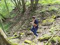
Taking the path to the hash though we realized that there would be a vers steep drop towards the river going forward. Be the time the hash came close, it was a good 10 meters straight down - not great if you have a child with you.
Luckily, we didn't give up and around the next bend there was a well walked path going down right to the hash.
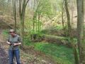
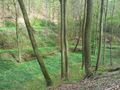
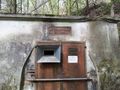
The area seems to be an abandoned mining something-or-the-other but we didn't investigate any further.
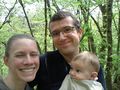
Coordinates reached, hashers happy :)
Tracklog
See here.
Photos
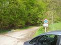
No parking. But if you stand close enough to the sign, you can't see it, right?
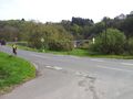
Parking with a view.
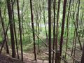
Hmm, that's too steep ...
OK, let's try around this corner.
Yep, that should be the way.
Abandoned mining tunnels?
Abandoned mining trash?
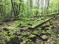
Lots of green rubble near the hash.
Hash dance with child.
Coordinates reached.
Stupid grin.
There was also this shortcut which we didn't see from above.


Achievements
- Land