Difference between revisions of "2012-05-05 47 7"
imported>Frizzy (there is no plan) |
imported>FippeBot m (Location) |
||
| (6 intermediate revisions by 2 users not shown) | |||
| Line 25: | Line 25: | ||
== Plans == | == Plans == | ||
Want to go there by bike tomorrow at 4 pm and do a little picknick. | Want to go there by bike tomorrow at 4 pm and do a little picknick. | ||
| + | Update: Weather looks not really nice, hope it wont rain. | ||
== Expedition == | == Expedition == | ||
| + | Weather looked really awful, so I took the red car from Gundelfingen to Sölden. In Sölden I found a parking place right after a few meters and I started my little hike to the cash. Fortunately it didn't rain and the footpath was very nice. The first 500 meters was along a small street but then it became a small hiking trail through those fields in this nice and wavy landscape. The hashpoint was located on a mowed and fertilized field. Fortunately there were no young plants growing, so I could pass the field and easily find the right spot. Because of the fertilizer I decided to do my picknick on the top of the hill in normal grass a couple of meters away from the hashpoint. I stayed there until meetup time, but no one showed up. Nothing special happend and I took another route back home to enjoy a bit more of this nice landscape. | ||
| + | == Photos == | ||
| + | <gallery perrow="5"> | ||
| + | File:2012-05-05_47_7_corsa.jpg | The red car took me to Sölden. | ||
| + | File:2012-05-05_47_7_gps.jpg | Here it is... | ||
| + | File:2012-05-05_47_7_fuesse.jpg | ...on a mowed and fertilized field. | ||
| + | File:2012-05-05_47_7_umgebung.jpg | Very nice view of the Black Forest. | ||
| + | File:2012-05-05_47_7_wike.jpg | Happy hasher^^ | ||
| + | File:2012-05-05_47_7_picknick.jpg | Proof for the picknick-achievement :) | ||
| + | File:2012-05-05_47_7_apfel.jpg | Just a tasty apple. | ||
| + | </gallery> | ||
| − | == | + | == Achievements == |
| + | {{land geohash | ||
| + | | latitude = 47 | ||
| + | | longitude = 7 | ||
| + | | date = 2012-05-05 | ||
| + | | name = Frizzy | ||
| − | + | }} | |
| + | |||
| + | {{Picnic_geohash | ||
| + | | latitude = 47 | ||
| + | | longitude = 7 | ||
| + | | date = 2012-05-05 | ||
| + | | name = Frizzy | ||
| + | | image = 2012-05-05_47_7_picknick.jpg | ||
| + | | food = apple, camembert cheese, purple balisto and some rice wafers | ||
| + | |||
| + | }} | ||
[[Category:Expeditions]] | [[Category:Expeditions]] | ||
| + | [[Category:Expeditions with photos]] | ||
| + | [[Category:Coordinates reached]] | ||
| + | {{location|DE|BW|FR}} | ||
Latest revision as of 03:49, 13 August 2019
| Sat 5 May 2012 in 47,7: 47.9300117, 7.7941584 geohashing.info google osm bing/os kml crox |
Location
In the fields near Bad Krozingen.
Participants
Plans
Want to go there by bike tomorrow at 4 pm and do a little picknick. Update: Weather looks not really nice, hope it wont rain.
Expedition
Weather looked really awful, so I took the red car from Gundelfingen to Sölden. In Sölden I found a parking place right after a few meters and I started my little hike to the cash. Fortunately it didn't rain and the footpath was very nice. The first 500 meters was along a small street but then it became a small hiking trail through those fields in this nice and wavy landscape. The hashpoint was located on a mowed and fertilized field. Fortunately there were no young plants growing, so I could pass the field and easily find the right spot. Because of the fertilizer I decided to do my picknick on the top of the hill in normal grass a couple of meters away from the hashpoint. I stayed there until meetup time, but no one showed up. Nothing special happend and I took another route back home to enjoy a bit more of this nice landscape.
Photos
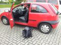
The red car took me to Sölden.
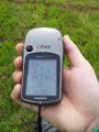
Here it is...
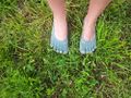
...on a mowed and fertilized field.
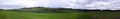
Very nice view of the Black Forest.
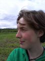
Happy hasher^^
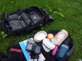
Proof for the picknick-achievement :)
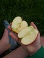
Just a tasty apple.


Achievements
Frizzy earned the Land geohash achievement
|
Frizzy earned the Picnic achievement
|