Difference between revisions of "2012-05-10 35 -91"
imported>Haberdasher m |
imported>Haberdasher m (→Achievements) |
||
| Line 54: | Line 54: | ||
| longitude = -91 | | longitude = -91 | ||
| date = 2012-05-10 | | date = 2012-05-10 | ||
| + | | name = Haberdasher | ||
| + | }} | ||
| + | |||
| + | {{gratuitous ribbon | ||
| + | | color = green | ||
| + | | latitude = 35 | ||
| + | | longitude = -91 | ||
| + | | date = 2012-05-10 | ||
| + | | achievement = Hashdog achievement | ||
| + | | description = finding a dog and stopping to pat it near the | ||
| name = Haberdasher | | name = Haberdasher | ||
}} | }} | ||
Revision as of 02:52, 11 May 2012
| Thu 10 May 2012 in 35,-91: 35.0602154, -91.8839399 geohashing.info google osm bing/os kml crox |
Location
Field in a residential neighborhood in Beebe, Arkansas.
Participants
Plans
Heading there on the first leg of my road trip home, probably around 12:30.
Expedition
A successful hash! Unfortunately, proof is somewhat lacking, but hopefully the story will help with what the pictures don't...
Today was the first leg of the family road trip back from my college in Arkansas to back home near Chicago. I knew I wanted to go geohashing along the way, and while the last few days' hashes hadn't been cooperative, today's were. I suggested two especially promising hashes, and while my parents made Deliverance jokes about a possible Ambassador hash near the Arkansas/Missouri border and could not be swayed to go despite my insistence that I'd only hash with the residents' permission, this one worked. It wouldn't delay us for long, it wouldn't require much hiking, and it was in open, probably unused space in a residential neighborhood, not anywhere particularly sketchy. Plus, as my mother pointed out, it'd mean taking the backroads rather than the same old highway route, which was a plus. So we agreed to do this hash.
The ride to Beebe wasn't too long, less than an hour from the hotel near my school, and my initial time estimate of 12:30 ended up being pretty accurate. Beebe is a decent-sized town, and none of us had ever been there before, but you might recognize it as the town where dead birds rained from the sky on New Year's. A bit unsettling, but hey, at least the town has SOME claim to fame. At first glance the field where the hash was reminded me of the one I'd hashed in Dekalb back in March, but there were two main differences: This hash lacked the nice clear path to the hashpoint, but it also wasn't nearly as brambly, so I only got one minor scratch during my GPS dance. A decent trade-off.
I'd assumed that the field was an unused lot, similar to the aforementioned Dekalb field, but I was quickly disabused of this idea when, upon taking a few steps into the field, I was ambushed by a pair of small, energetic beagles. I couldn't determine the owner of the two dogs, and they seemed more curious than concerned about this unexpected visitor to their property, so while I was careful to avoid stepping on the dogs or anything that could be used by the property's owners, I continued my GPS dance as the hashdogs followed me, eventually petting one's head upon vague memory of the Hashcat achievement's requiring something similar.
At the end of my GPS dance, I took a picture of the GPS showing the all-important hashpoint digits, but the sun was quite bright, and even when I put the GPS in my shadow, the glare obscured the screen. I took a picture in the hopes that the phone's screen glare was the real problem, but you can't see much of anything on the GPS in said picture, one of those below. You'll just have to take my word for it. I did take a picture of the date, but taking a picture of one phone with another in a car led to blurry pictures, and ended up being unnecessary since I'm posting this the day of the hash. And I also forgot to take a picture of my Stupid Grin until we were a few miles away, unfortunately. Next time I'll try to be more on the ball.
The rest of the trip was fairly uneventful. Arkansas had a lot of crosses and churches, unsurprisingly. The backroads route we took had less hills and forests than usual, but more fields, livestock, discount/thrift/antique stores, and cemeteries. There were a few points of interest- Dicky's Racing Parts, the McDonald's across the street from a cemetery, Cash Assembly of God (a small church in the equally-small town of Cash, Arkansas), the barbecue restaurant in the middle of nowhere which apparently doubled as a tie-dye shirt store- but we didn't stop much or for anything too exciting. The point was getting back, with enjoying the ride as an incidental bonus. The trip isn't over, either, so I might be able to hit another hashpoint or two tomorrow on our way back home.
Photos

Proof of date, such as it is
Attempted proof of reaching the hash
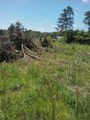
Area around the hash
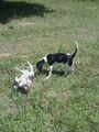
Hashdogs
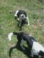
Hashdogs again


Achievements
Haberdasher earned the Hashdog achievement
|