Difference between revisions of "2012-05-13 36 -76"
imported>ChrisG (→Expedition) |
imported>FippeBot m (Location) |
||
| (6 intermediate revisions by one other user not shown) | |||
| Line 33: | Line 33: | ||
We left Durham, NC at noon, and worked our way across NC and southeastern VA. Rolling hills, lots of trees, and farmland. Only one traffic tie-up, and that was within 2 miles of the hashpoint. | We left Durham, NC at noon, and worked our way across NC and southeastern VA. Rolling hills, lots of trees, and farmland. Only one traffic tie-up, and that was within 2 miles of the hashpoint. | ||
| − | The hashpoint was on the grounds of Maury High School, in the athletic fields. The school seemed nice enough, but the homeless folks who were lounging near the driveway/entrance sketched WifeyGirl out a a bit. We parked in the space reserved for the maintenance crew, and took a quick walk over to the hashpoint. I unfortunately wasn't traveling with athletic gear, and the tennis courts were locked, anyway. | + | The hashpoint was on the grounds of Maury High School, in the athletic fields. We arrived about 3:45PM. The school seemed nice enough, but the homeless folks who were lounging near the driveway/entrance sketched WifeyGirl out a a bit. We parked in the space reserved for the maintenance crew, and took a quick walk over to the hashpoint. I unfortunately wasn't traveling with athletic gear, and the tennis courts were locked, anyway. |
We continued our trip, taking the bridge/tunnel (and paying the $12 toll), and drove up the Delmarva peninsula, covering territory I hadn't seen in 15 years. We spent the night in Rehoboth Beach, Delaware, before making our way home. | We continued our trip, taking the bridge/tunnel (and paying the $12 toll), and drove up the Delmarva peninsula, covering territory I hadn't seen in 15 years. We spent the night in Rehoboth Beach, Delaware, before making our way home. | ||
| Line 40: | Line 40: | ||
<gallery> | <gallery> | ||
| − | Image:2012-05-13_36_-76_15-28-44-005.jpg | Tennis, | + | Image:2012-05-13_36_-76_15-28-44-005.jpg | Tennis, anyone? [http://www.openstreetmap.org/?lat=36.86543389&lon=-76.28883418&zoom=16&layers=B000FTF @36.8654,-76.2888] |
| + | |||
| + | Image:2012-05-13_36_-76_11-00-24-630.jpg | On your mark, get set, go! | ||
</gallery> | </gallery> | ||
| Line 49: | Line 51: | ||
== Achievements == | == Achievements == | ||
{{#vardefine:ribbonwidth|800px}} | {{#vardefine:ribbonwidth|800px}} | ||
| + | |||
| + | I thought for sure that I'd be able to pull off the Tron Achievement, at least as far as the graticule was concerned, but the orientation of the high school driveway made that infeasible. So, just the standard land hash | ||
| + | |||
| + | |||
<!-- Add any achievement ribbons you earned below, or remove this section --> | <!-- Add any achievement ribbons you earned below, or remove this section --> | ||
| − | |||
| − | |||
| − | |||
| − | |||
| − | |||
| − | |||
| − | |||
| − | + | ||
[[Category:Expeditions]] | [[Category:Expeditions]] | ||
| − | |||
[[Category:Expeditions with photos]] | [[Category:Expeditions with photos]] | ||
| − | |||
| − | |||
| − | |||
| − | |||
| − | |||
[[Category:Coordinates reached]] | [[Category:Coordinates reached]] | ||
| − | + | {{location|US|VA|NF}} | |
| − | |||
| − | |||
| − | |||
| − | |||
| − | |||
| − | |||
| − | |||
| − | |||
| − | |||
Latest revision as of 04:51, 6 August 2019
| Sun 13 May 2012 in 36,-76: 36.8654550, -76.2888676 geohashing.info google osm bing/os kml crox |
Location
In Norfolk, Virginia, at some sort of park/athletic center on Llewellyn Avenue
Participants
ChrisG and WifeyGirl.
Plans
I'm driving from Durham, NC northward today toward Rhode Island, and this geohash is on one of my possible routes home. Hoping to be at the hash in the late afternoon, before I take the bridge/tunnel to DelMarVa.
Expedition
I'm still on the road, so this will be short for now. Took the long way from North Carolina to Rhode Island, because I wanted to go over (and through) the Chesapeake Bay Bridge/Tunnel. That there was an easy hashpoint along the way was a bonus.
We left Durham, NC at noon, and worked our way across NC and southeastern VA. Rolling hills, lots of trees, and farmland. Only one traffic tie-up, and that was within 2 miles of the hashpoint.
The hashpoint was on the grounds of Maury High School, in the athletic fields. We arrived about 3:45PM. The school seemed nice enough, but the homeless folks who were lounging near the driveway/entrance sketched WifeyGirl out a a bit. We parked in the space reserved for the maintenance crew, and took a quick walk over to the hashpoint. I unfortunately wasn't traveling with athletic gear, and the tennis courts were locked, anyway.
We continued our trip, taking the bridge/tunnel (and paying the $12 toll), and drove up the Delmarva peninsula, covering territory I hadn't seen in 15 years. We spent the night in Rehoboth Beach, Delaware, before making our way home.
Photos
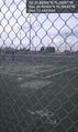
Tennis, anyone? @36.8654,-76.2888
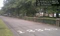
On your mark, get set, go!


Achievements
I thought for sure that I'd be able to pull off the Tron Achievement, at least as far as the graticule was concerned, but the orientation of the high school driveway made that infeasible. So, just the standard land hash