Difference between revisions of "2012-05-14 42 -87"
From Geohashing
imported>Swoop2 (→Photos) |
imported>FippeBot m (Location) |
||
| (2 intermediate revisions by 2 users not shown) | |||
| Line 1: | Line 1: | ||
| − | |||
<!-- If you did not specify these parameters in the template, please substitute appropriate values for IMAGE, LAT, LON, and DATE (YYYY-MM-DD format) | <!-- If you did not specify these parameters in the template, please substitute appropriate values for IMAGE, LAT, LON, and DATE (YYYY-MM-DD format) | ||
| Line 10: | Line 9: | ||
}} | }} | ||
| − | + | ||
__NOTOC__ | __NOTOC__ | ||
== Location == | == Location == | ||
| − | + | ||
| − | This one is located near the corner of Dundee Road and Buffalo Grove Road in Buffalo Grove, IL. | + | This one is located near the corner of Dundee Road and Buffalo Grove Road in Buffalo Grove, IL. |
| + | |||
It is on an access path for a cell tower. Behind a real estate office. | It is on an access path for a cell tower. Behind a real estate office. | ||
== Participants == | == Participants == | ||
| − | + | ||
| − | |||
[[User:Swoop2|Phil]] and [[User:TJAMM|Mary]] a co-worker | [[User:Swoop2|Phil]] and [[User:TJAMM|Mary]] a co-worker | ||
== Expedition == | == Expedition == | ||
| − | + | ||
Discovered that the location was close to work. We drove over after lunch. Pretty easy. | Discovered that the location was close to work. We drove over after lunch. Pretty easy. | ||
| − | From TJAMM | + | === From TJAMM=== |
| − | + | When Swoop2 said where the location of this geohash was, it took all that I had not to run right then. | |
| − | + | ||
| + | It was like a FTF (First to Find) for Geocaching! :-) | ||
== Photos == | == Photos == | ||
| − | + | ||
| − | |||
| − | |||
<gallery perrow="5"> | <gallery perrow="5"> | ||
Image:2012-05-14 42 -87 Proof.jpg|Proof | Image:2012-05-14 42 -87 Proof.jpg|Proof | ||
| Line 44: | Line 42: | ||
== Achievements == | == Achievements == | ||
{{#vardefine:ribbonwidth|800px}} | {{#vardefine:ribbonwidth|800px}} | ||
| − | + | ||
{{land geohash | {{land geohash | ||
| latitude = 42 | | latitude = 42 | ||
| Line 50: | Line 48: | ||
| date = 2012-05-14 | | date = 2012-05-14 | ||
| name = Swoop2 | | name = Swoop2 | ||
| − | |||
}} | }} | ||
| Line 56: | Line 53: | ||
| latitude = 42 | | latitude = 42 | ||
| longitude = -87 | | longitude = -87 | ||
| − | | date = | + | | date = 2012-05-14 |
| partner = TJAMM | | partner = TJAMM | ||
| name = Swoop2 | | name = Swoop2 | ||
| − | |||
}} | }} | ||
{{land geohash | {{land geohash | ||
| Line 66: | Line 62: | ||
| date = 2012-05-14 | | date = 2012-05-14 | ||
| name = TJAMM | | name = TJAMM | ||
| − | |||
}} | }} | ||
| − | |||
| − | |||
| − | |||
| − | |||
| − | |||
| − | |||
| − | |||
| − | + | ||
| + | |||
| + | |||
[[Category:Expeditions]] | [[Category:Expeditions]] | ||
| − | |||
[[Category:Expeditions with photos]] | [[Category:Expeditions with photos]] | ||
| − | |||
| − | |||
| − | |||
| − | |||
| − | |||
[[Category:Coordinates reached]] | [[Category:Coordinates reached]] | ||
| − | + | {{location|US|IL|CO}} | |
| − | |||
| − | |||
| − | |||
| − | |||
| − | |||
| − | |||
| − | |||
| − | |||
| − | |||
Latest revision as of 03:59, 13 August 2019
| Mon 14 May 2012 in 42,-87: 42.1377452, -87.9602435 geohashing.info google osm bing/os kml crox |
Location
This one is located near the corner of Dundee Road and Buffalo Grove Road in Buffalo Grove, IL.
It is on an access path for a cell tower. Behind a real estate office.
Participants
Expedition
Discovered that the location was close to work. We drove over after lunch. Pretty easy.
From TJAMM
When Swoop2 said where the location of this geohash was, it took all that I had not to run right then.
It was like a FTF (First to Find) for Geocaching! :-)
Photos
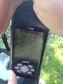
Proof

Silly grins
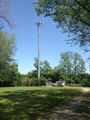
Cell tower at the end of the path.
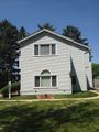
Nearby business


Achievements
Swoop2 earned the Land geohash achievement
|
Swoop2 earned the Drag-along achievement
|
TJAMM earned the Land geohash achievement
|