Difference between revisions of "2012-05-14 46 -122"
From Geohashing
imported>Michael5000 m (→Participants) |
imported>Michael5000 |
||
| Line 1: | Line 1: | ||
| − | |||
| − | |||
| − | |||
| − | |||
| − | |||
{{meetup graticule | {{meetup graticule | ||
| lat=46 | | lat=46 | ||
| Line 18: | Line 13: | ||
== Participants == | == Participants == | ||
| − | [[User:Michael5000|Michael5000]] | + | *[[User:Michael5000|Michael5000]] |
== Plans == | == Plans == | ||
| − | + | ||
| + | This was clearly not going to be very interesting, but it was an easy stop-over hashpoint on the way to [[2012-05-14 46 -122]]. | ||
== Expedition == | == Expedition == | ||
| − | |||
| − | + | I parked in the alley, took a few pictures of the backyard utility building that stands on the hashpoint, and called it good. | |
| − | + | ||
== Photos == | == Photos == | ||
| Line 34: | Line 29: | ||
--> | --> | ||
<gallery perrow="5"> | <gallery perrow="5"> | ||
| + | File:2012-05-14 46 -122 alley.JPG|The alley, with the building to the right... | ||
| + | File:2012-05-14 46 -122 building.JPG|and there's the building, sitting right on top of the hashpoint! | ||
</gallery> | </gallery> | ||
== Achievements == | == Achievements == | ||
{{#vardefine:ribbonwidth|800px}} | {{#vardefine:ribbonwidth|800px}} | ||
| − | |||
| − | |||
| − | |||
| − | |||
| − | |||
| − | |||
| − | |||
| − | |||
| − | |||
| − | |||
| − | |||
| − | |||
| − | |||
[[Category:Expeditions]] | [[Category:Expeditions]] | ||
| − | |||
[[Category:Expeditions with photos]] | [[Category:Expeditions with photos]] | ||
| − | |||
| − | |||
| − | |||
| − | |||
| − | |||
[[Category:Coordinates reached]] | [[Category:Coordinates reached]] | ||
| − | |||
| − | |||
| − | |||
| − | |||
| − | |||
| − | |||
| − | |||
| − | |||
| − | |||
| − | |||
Revision as of 19:12, 15 May 2012
| Mon 14 May 2012 in 46,-122: 46.1377452, -122.9602435 geohashing.info google osm bing/os kml crox |
Location
Off an alley in Longview, Washington.
Participants
Plans
This was clearly not going to be very interesting, but it was an easy stop-over hashpoint on the way to 2012-05-14 46 -122.
Expedition
I parked in the alley, took a few pictures of the backyard utility building that stands on the hashpoint, and called it good.
Photos
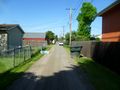
The alley, with the building to the right...
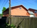
and there's the building, sitting right on top of the hashpoint!

