Difference between revisions of "2012-05-15 48 11"
imported>DerFlob m (template) |
imported>FippeBot m (Location) |
||
| (4 intermediate revisions by one other user not shown) | |||
| Line 1: | Line 1: | ||
| − | |||
| − | |||
| − | |||
| − | |||
| − | |||
{{meetup graticule | {{meetup graticule | ||
| lat=48 | | lat=48 | ||
| Line 13: | Line 8: | ||
__NOTOC__ | __NOTOC__ | ||
== Location == | == Location == | ||
| − | + | On a meadow outside of Lochhausen, NW of München. | |
== Participants == | == Participants == | ||
| − | + | *[[User:DerFlob|DerFlob]] | |
| − | |||
== Plans == | == Plans == | ||
| − | + | [[2012-05-15 48 11]] seems quite easy, near S3 Lochhausen. I'd go there after university and reach it probably shortly after 5 p.m. --[[User:DerFlob|DerFlob]] 10:53, 14 May 2012 (EDT) | |
| + | :I'd probably aim to fill my lunch break with the expedition. ETA would be around 11:45 -[[User:The T-Man|The T-Man]] 15:05, 14 May 2012 (EDT) | ||
== Expedition == | == Expedition == | ||
| − | + | A rather straightforward trip. After my lecture has ended, I found out, that the one after that was cancelled and I could go two hours earlier than previously planned. I took the subway from Garching-Forschungszentrum, switched at Marienplatz into a suburban train and got of the train at Lochhausen. From there I was a walk of about 1.2 km to the hashpoint. Unfortunately the meadow, where the point was located, was fenced off and got only within 16 metres of the hash. | |
| − | |||
| − | |||
| − | |||
== Photos == | == Photos == | ||
| − | |||
| − | |||
| − | |||
<gallery perrow="5"> | <gallery perrow="5"> | ||
| + | Image:2012-05-15_48_11_Flob_1.jpg | About 16 metres past this fence lies the hash | ||
| + | Image:2012-05-15_48_11_Flob_2.jpg | Stupid grin anyway | ||
| + | Image:2012-05-15_48_11_Flob_3.jpg | The closest I could get | ||
</gallery> | </gallery> | ||
| − | |||
| − | |||
| − | |||
| − | |||
| − | |||
| − | |||
| − | |||
| − | |||
| − | |||
| − | |||
| − | |||
| − | |||
| − | |||
| − | |||
| − | |||
[[Category:Expeditions]] | [[Category:Expeditions]] | ||
| − | |||
[[Category:Expeditions with photos]] | [[Category:Expeditions with photos]] | ||
| − | |||
| − | |||
| − | |||
| − | |||
| − | |||
| − | |||
| − | |||
| − | |||
[[Category:Coordinates not reached]] | [[Category:Coordinates not reached]] | ||
| − | + | [[Category:Not reached - No public access]] | |
| − | + | {{location|DE|BY|M|city=true}} | |
| − | [[Category:Not reached - No public access]] | ||
| − | |||
| − | |||
| − | |||
Latest revision as of 04:01, 13 August 2019
| Tue 15 May 2012 in 48,11: 48.1853632, 11.4111400 geohashing.info google osm bing/os kml crox |
Location
On a meadow outside of Lochhausen, NW of München.
Participants
Plans
2012-05-15 48 11 seems quite easy, near S3 Lochhausen. I'd go there after university and reach it probably shortly after 5 p.m. --DerFlob 10:53, 14 May 2012 (EDT)
- I'd probably aim to fill my lunch break with the expedition. ETA would be around 11:45 -The T-Man 15:05, 14 May 2012 (EDT)
Expedition
A rather straightforward trip. After my lecture has ended, I found out, that the one after that was cancelled and I could go two hours earlier than previously planned. I took the subway from Garching-Forschungszentrum, switched at Marienplatz into a suburban train and got of the train at Lochhausen. From there I was a walk of about 1.2 km to the hashpoint. Unfortunately the meadow, where the point was located, was fenced off and got only within 16 metres of the hash.
Photos
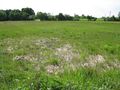
About 16 metres past this fence lies the hash
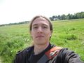
Stupid grin anyway
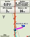
The closest I could get


