Difference between revisions of "2012-05-17 48 9"
imported>LarsVegas |
imported>FippeBot m (Location) |
||
| (8 intermediate revisions by 2 users not shown) | |||
| Line 10: | Line 10: | ||
| graticule_link=Stuttgart, Germany}} | | graticule_link=Stuttgart, Germany}} | ||
| − | + | ||
__NOTOC__ | __NOTOC__ | ||
== Location == | == Location == | ||
| − | + | ||
| − | A small plantation in a marsh area near the Hölzer See. Hölzer See is a small lake used as a fishing | + | A small plantation in a marsh area near the Hölzer See. Hölzer See is a small lake used as a fishing basin near Magstadt, Germany. |
== Participants == | == Participants == | ||
| − | + | ||
| − | + | * [[User:LarsVegas|Lars Vegas]] visited the place in the evening. Nobody seemed to be there during the day. | |
| − | [[User:LarsVegas|Lars Vegas]] visited the place in the evening. Nobody | ||
== Plans == | == Plans == | ||
| − | + | ||
| − | I received my first Garmin yesterday and planned to make a trip with the kids in the afternoon after a trip to a wildlife park. | + | I received my first Garmin yesterday and planned to make a trip with the kids in the afternoon after a trip to a wildlife park. |
== Expedition == | == Expedition == | ||
<!-- how it all turned out. your narrative goes here. --> | <!-- how it all turned out. your narrative goes here. --> | ||
| − | I stumbled upon geohashing about two weeks ago. After already having worked for OSM (using my cellphone or available background images), I was all for it in a second. I just didn't own a GPS device, nor was any of the hashes suitable during that time. Yesterday I received a parcel with a Garmin eTrex 10 (my first real GPS device at all) and today the hashpoint was quite close to where I live. | + | I stumbled upon geohashing about two weeks ago. After already having worked for OSM |
| + | (using my cellphone or available background images), I was all for it in a second. | ||
| + | I just didn't own a GPS device, nor was any of the hashes suitable during that time. | ||
| + | Yesterday I received a parcel with a Garmin eTrex 10 (my first real GPS device at all) | ||
| + | and today the hashpoint was quite close to where I live. | ||
| − | We planned to have a | + | We planned to have a day trip with some friends to a wildlife park near Cleebronn, |
| + | Germany (Tripsdrill) and visit the hashpoint afterwards in the afternoon. Of course | ||
| + | the trip took longer than expected, but it was worth every minute. However, it was | ||
| + | too late for my kids to participate. So after they went to bed (20:00 CEST) I took | ||
| + | the car and drove to a parking lot near the Hölzer See. There's a small pub | ||
| + | (Fischerhütte am Hölzer See) but nobody was there anymore. The place is close | ||
| + | to a highway but in the middle of the forest, so it's more of a daytime attraction. | ||
| − | At the lake, a graveled footpath lead into the woods. After approx. 100m the path wasn't graveled anymore but clearly visible. I was still fighting a little bit with my brand new device but knew the way more or less from the map. About 150m before the hashpoint I had to leave the path and make my way through marshland. Fortunately that area was already quite dry with only sporadic ditches to cross. I found the right place quickly but had to dance around a bit to finally hit the 0m spot. I took the mandatory images and because it started to darken headed home quite soon. But only after pinning the sheet to a tree | + | At the lake, a graveled footpath lead into the woods. After approx. 100m the path |
| + | wasn't graveled anymore but clearly visible. I was still fighting a little bit with | ||
| + | my brand new device but knew the way more or less from the map. About 150m before the | ||
| + | hashpoint I had to leave the path and make my way through marshland. Fortunately that | ||
| + | area was already quite dry with only sporadic ditches to cross. I found the right place | ||
| + | quickly but had to dance around a bit to finally hit the 0m spot. I took the mandatory | ||
| + | images and because it started to darken headed home quite soon. But only after pinning | ||
| + | the sheet to a tree. | ||
Overall it took me about one hour and it was quite nice for my very first geohash. | Overall it took me about one hour and it was quite nice for my very first geohash. | ||
| − | == | + | == Photos == |
| − | |||
| − | |||
| − | |||
| − | |||
| − | |||
<gallery perrow="5"> | <gallery perrow="5"> | ||
| + | Image:2012-05-17_48_9_Hoelzer_See.JPG | Hölzer See at sunset | ||
| + | Image:2012-05-17_48_9_Ditch.JPG | One of the ditches to cross | ||
| + | Image:2012-05-17_48_9_Marshland.JPG | Marshland to the east of the hashpoint | ||
| + | Image:2012-05-17_48_9_Plantation.JPG | There is the hashpoint - at just that tree | ||
| + | Image:2012-05-17_48_9_GPS_Proof_LarsVegas.JPG | I was there! My first geohash | ||
</gallery> | </gallery> | ||
== Achievements == | == Achievements == | ||
{{#vardefine:ribbonwidth|800px}} | {{#vardefine:ribbonwidth|800px}} | ||
| − | |||
| + | {{land geohash | ||
| + | |||
| + | | latitude = 48 | ||
| + | | longitude = 9 | ||
| + | | date = 2012-05-17 | ||
| + | | name = Lars Vegas | ||
| + | |||
| + | }} | ||
| − | |||
| − | |||
| − | |||
| − | |||
[[Category:Expeditions]] | [[Category:Expeditions]] | ||
| − | |||
[[Category:Expeditions with photos]] | [[Category:Expeditions with photos]] | ||
| − | + | ||
| − | |||
| − | |||
[[Category:Coordinates reached]] | [[Category:Coordinates reached]] | ||
| − | + | {{location|DE|BW|BB}} | |
Latest revision as of 04:03, 13 August 2019
| Thu 17 May 2012 in Stuttgart: 48.7491023, 9.0242625 geohashing.info google osm bing/os kml crox |
Location
A small plantation in a marsh area near the Hölzer See. Hölzer See is a small lake used as a fishing basin near Magstadt, Germany.
Participants
- Lars Vegas visited the place in the evening. Nobody seemed to be there during the day.
Plans
I received my first Garmin yesterday and planned to make a trip with the kids in the afternoon after a trip to a wildlife park.
Expedition
I stumbled upon geohashing about two weeks ago. After already having worked for OSM (using my cellphone or available background images), I was all for it in a second. I just didn't own a GPS device, nor was any of the hashes suitable during that time. Yesterday I received a parcel with a Garmin eTrex 10 (my first real GPS device at all) and today the hashpoint was quite close to where I live.
We planned to have a day trip with some friends to a wildlife park near Cleebronn, Germany (Tripsdrill) and visit the hashpoint afterwards in the afternoon. Of course the trip took longer than expected, but it was worth every minute. However, it was too late for my kids to participate. So after they went to bed (20:00 CEST) I took the car and drove to a parking lot near the Hölzer See. There's a small pub (Fischerhütte am Hölzer See) but nobody was there anymore. The place is close to a highway but in the middle of the forest, so it's more of a daytime attraction.
At the lake, a graveled footpath lead into the woods. After approx. 100m the path wasn't graveled anymore but clearly visible. I was still fighting a little bit with my brand new device but knew the way more or less from the map. About 150m before the hashpoint I had to leave the path and make my way through marshland. Fortunately that area was already quite dry with only sporadic ditches to cross. I found the right place quickly but had to dance around a bit to finally hit the 0m spot. I took the mandatory images and because it started to darken headed home quite soon. But only after pinning the sheet to a tree.
Overall it took me about one hour and it was quite nice for my very first geohash.
Photos
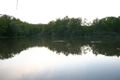
Hölzer See at sunset
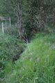
One of the ditches to cross
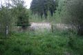
Marshland to the east of the hashpoint
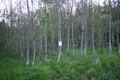
There is the hashpoint - at just that tree
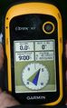
I was there! My first geohash


Achievements
Lars Vegas earned the Land geohash achievement
|