Difference between revisions of "2012-05-17 49 10"
imported>Danatar (Report!) |
imported>Danatar m (tracklog) |
||
| Line 35: | Line 35: | ||
===tracklog=== | ===tracklog=== | ||
| − | + | [http://www.everytrail.com/view_trip.php?trip_id=1597588&code=c998ac053c18860acd105cb4be01766d Triton tracklog] | |
[[Category:Expeditions]] | [[Category:Expeditions]] | ||
Revision as of 15:48, 27 May 2012
| Thu 17 May 2012 in Bamberg: 49.7491023, 10.0242625 geohashing.info google osm bing/os kml crox |
Location
Today's location is in a field with young corn at Theilheim, near Würzburg.
Country: Germany; state: Bayern (Bavaria, EU:DE:BY); administrative region: Unterfranken; district: Würzburg rural district.
Weather: fresh but sunny, about 13 °C
Expedition
Danatar
It's Ascension Thursday and I don't have to work. The weather was very nice and I cycled along the Main river to Randersacker, then uphill to Theilheim. After braving the steep streets in Theilheim, I reached the hashfield, with the hashpoint right in the middle of it. I cycled around it first and noticed tractor tracks going straight through it. A group of people were taking a walk next to the field, so I waited for them to vanish around a corner before following the tractor tracks. They brought me within 4 metres of the hashpoint. I didn't want to trample any plants, so I called it a success and took my pictures.
After a celebratory snack I went back to my bike and cycled to Würzburg. After a detour to the gym I arrived back home.
I cycled 25.3 km.
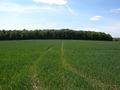
almost there
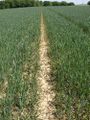
conveniently placed tractor tracks
GPS

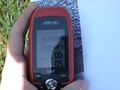
Coordinates reached!