Difference between revisions of "2012-05-17 59 19"
imported>Cjk (Hashtree [http://www.openstreetmap.org/?lat=59.74890000&lon=19.02420000&zoom=16&layers=B000FTF @59.7489,19.0242]) |
m (per Renaming Proposal) |
||
| (20 intermediate revisions by 3 users not shown) | |||
| Line 1: | Line 1: | ||
| − | + | {| width="100%" border=0 cellpadding=0 cellspacing=0 style="border: 0; border-collapse: collapse; border-spacing: 0; margin: 0; padding: 0" | |
| − | + | | align="left" valign="top" style="padding: 0.5em 1em 0.5em 0" | [[Image:2012-05-17 59 19 10 Geohashers.jpg|border|467px]] | |
| − | -- | + | |
| − | {{meetup graticule | + | | align="right" valign="top" | {{meetup graticule |
| lat=59 | | lat=59 | ||
| lon=19 | | lon=19 | ||
| date=2012-05-17 | | date=2012-05-17 | ||
| + | | graticule_name=Kapellskär | ||
| + | | graticule_link=Kapellskär, Sweden | ||
}} | }} | ||
| − | + | |} | |
| + | |||
__NOTOC__ | __NOTOC__ | ||
| + | |||
== Location == | == Location == | ||
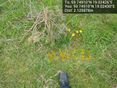
In a field 10 miles east of Norrtälje, Sweden. | In a field 10 miles east of Norrtälje, Sweden. | ||
| Line 17: | Line 21: | ||
* [[User:Per S|Per S]] | * [[User:Per S|Per S]] | ||
* [[User:Cjk|Cjk]] | * [[User:Cjk|Cjk]] | ||
| + | * TheFashionStatement | ||
== Plans == | == Plans == | ||
| − | *As tomorrow is Ascension Day which is a public holiday in Sweden, I have the day off. I will drive up there around noon. -- [[User:Per S|Per S]] | + | * As tomorrow is Ascension Day which is a public holiday in Sweden, I have the day off. I will drive up there around noon. -- [[User:Per S|Per S]] |
| − | *I'll leave in my car from Stockholm around noon -- [[User:Cjk|Cjk]] 05:37, 17 May 2012 (EDT) | + | * I'll leave in my car from Stockholm around noon -- [[User:Cjk|Cjk]] 05:37, 17 May 2012 (EDT) |
== Expedition == | == Expedition == | ||
| − | + | * Försten dit! -- [[User:Per S|Per S]] 15:43, 16 May 2012 (CEST) | |
| + | * I'll be there! -- [[User:Cjk|Cjk]] 16:16, 16 May 2012 (CEST) | ||
| + | * Made it. Deflowered. -- [[User:Cjk|Cjk]] [http://www.openstreetmap.org/?lat=59.74907355&lon=19.02427705&zoom=16&layers=B000FTF @59.7491,19.0243] 13:47, 17 May 2012 (CEST) | ||
| + | === Per S === | ||
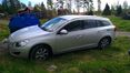
| + | I drove to the hash in a Volvo V60 from the car sharing. I arrived about half past twelve and found the hash point close to the road. I put up a marker on a tree a few yards away and then hung around waiting to see if Cjk would turn up. I didn't want to leave before he arrived, because then he wouldn't also get the virgin graticule achievement. | ||
| − | + | After about an hour I was about to leave, but while I was building a little pile of branches to mark the hash point, Cjk and TheFasionStatement arrived. I had a quick piece of cheese with them and then I had to rush off. The car had to be back by 3 pm sharp. I won't upload my tracklog as it's probably incriminating ;) | |
| − | + | === Cjk and TheFashionStatement === | |
| + | Per S and I had talked about deflowering Kapellskär (it is like 99% ocean) last time we met at the hash on Utö and he found this one and sent a message via the wiki. Of course I was going. Headed off from home to pick up TheFasionStatement on the pretense that it was a road trip. And it turned out to be a nice one. The GPS in the phone was on the fritz all the way so turn off points where a bit hard to find. Got close to the right field after about an hours drive and Per S was already there, the little Early Bird that he is. Big thanks for waiting an hour for us at the hash. | ||
| + | |||
| + | He had put up a sign on the nearest tree and built a little mound of branches on the spot. I packed up a small picnic with cutlery from home and some cheese and hard bread, Gruyere and Saint Agur. Per S had to speed off so we took a quick group photo and he took off. | ||
| + | |||
| + | Stayed some more minutes and took more photos before heading back. Had late lunch at Max and then road tripped a bit through Danderyd looking at houses and imagining the people in them. Then home to Stockholm and a quick visit to the Army Museum. | ||
| − | |||
== Tracklog == | == Tracklog == | ||
| − | + | * [http://maps.google.com/maps/ms?msa=0&msid=209560846421673743077.0004c03be5d8d61862af5 map] of ride back to Stockholm via Max Hamburgers and a drive around Danderyd | |
| − | == Photos == | + | == Photos == |
| − | < | + | === Per S === |
| − | Image: | + | <gallery widths=117px perrow="5"> |
| − | -- | + | Image:2012-05-17 59 19 1 Todays Citation.jpg | Today's [[Citation Needed|citation]] |
| − | <gallery | + | Image:2012-05-17 59 19 2 The Field.jpg | The Field |
| + | Image:2012-05-17 59 19 3 The Field.jpg | The Field | ||
| + | Image:2012-05-17 59 19 4 The Field.jpg | The Field | ||
| + | Image:2012-05-17 59 19 5 Coordinates Reached.jpg | Coordinates Reached | ||
| + | Image:2012-05-17 59 19 6 The Hashpoint.jpg | The Hashpoint | ||
| + | Image:2012-05-17 59 19 7 Geohasher.jpg | Geohasher | ||
| + | Image:2012-05-17 59 19 8 Marker.jpg | Marker | ||
| + | Image:2012-05-17 59 19 9 Picnic.jpg | Picnic | ||
| + | Image:2012-05-17 59 19 10 Geohashers.jpg | Geohashers | ||
| + | </gallery> | ||
| − | Image:2012-05-17_59_19_13-50-25-114.jpg | | + | === Cjk === |
| + | <gallery widths=117px perrow="5"> | ||
| + | Image:2012-05-17_59_19_20-00-29-108.jpg | Ready to take off. | ||
| + | Image:2012-05-17_59_19_20-01-30-053.jpg | TheFashionStatement | ||
| + | Image:2012-05-17_59_19_20-02-40-959.jpg | Structure and boat looked almost Viking. | ||
| + | Image:2012-05-17_59_19_13-50-25-114.jpg | [[User:Per S|Per S]] | ||
| + | Image:2012-05-17_59_19_20-04-14-896.jpg | TheFashionStatement at the hash. | ||
| + | Image:2012-05-17_59_19_13-53-34-338.jpg | [https://www.youtube.com/watch?v=9iH-vmOGh3s Russian Circles] | ||
| + | Image:2012-05-17_59_19_20-05-14-991.jpg | Russian Circles | ||
| + | Image:2012-05-17_59_19_20-05-46-135.jpg | Hashtree | ||
| + | Image:2012-05-17_59_19_20-06-16-628.jpg | View of the hash | ||
| + | Image:2012-05-17_59_19_20-06-35-548.jpg | ||
| + | Image:2012-05-17_59_19_13-53-55-744.jpg | Orange™ | ||
| + | Image:2012-05-17_59_19_20-07-23-406.jpg | Some fun at the army museum. | ||
| + | </gallery> | ||
| + | |||
| + | == Achievements == | ||
| + | {{#vardefine:ribbonwidth|100%}} | ||
| + | |||
| + | {| | ||
| − | + | |{{Earliest geohasher | |
| + | | latitude = 59 | ||
| + | | longitude = 19 | ||
| + | | date = 2012-05-17 | ||
| + | | name = [[User:Per S|Per S]] | ||
| + | | image = 2012-05-17 59 19 7 Geohasher.jpg | ||
| + | }} | ||
| − | + | |- | |
| − | + | |{{Minesweeper geohash | |
| + | | graticule = Stockholm, Sweden | ||
| + | | ranknumber = 4 | ||
| + | | e = true | ||
| + | | s = true | ||
| + | | sw = true | ||
| + | | w = true | ||
| + | | name = [[User:Per S|Per S]] | ||
| + | }} | ||
| + | |||
| + | |- | ||
| + | |||
| + | |{{Minesweeper geohash | ||
| + | | graticule = Stockholm, Sweden | ||
| + | | ranknumber = 6 | ||
| + | | n = true | ||
| + | | e = true | ||
| + | | s = true | ||
| + | | sw = true | ||
| + | | w = true | ||
| + | | nw=true | ||
| + | | name = [[User:Cjk|Cjk]] | ||
| + | }} | ||
| + | |||
| + | |- | ||
| + | |||
| + | |{{Graticule unlocked | ||
| + | | latitude = 59 | ||
| + | | longitude = 19 | ||
| + | | date = 2012-05-17 | ||
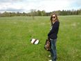
| + | | name = [[User:Per S|Per S]], [[User:Cjk|Cjk]] and TheFashionStatement | ||
| + | | image = 2012-05-17 59 19 10 Geohashers.jpg }} | ||
| − | + | |- | |
| − | + | |{{Picnic_geohash | |
| + | | latitude = 59 | ||
| + | | longitude = 19 | ||
| + | | date = 2012-05-17 | ||
| + | | name = [[User:Per S|Per S]], [[User:Cjk|Carl-Johan]] and TheFashionStatement | ||
| + | | image = 2012-05-17 59 19 9 Picnic.jpg | ||
| + | | food = Gruyere and Saint Agur cheese on Batanun hard bread | ||
| + | }} | ||
| − | + | |- | |
| − | + | |{{drag-along | |
| + | | latitude = 59 | ||
| + | | longitude = 19 | ||
| + | | date = 2012-05-17 | ||
| + | | name = [[User:Cjk|Cjk]] | ||
| + | | partner = TheFashionStatement | ||
| + | | image = 2012-05-17_59_19_20-04-14-896.jpg | ||
| + | }} | ||
| − | + | |- | |
| − | |||
| − | == | + | |{{land geohash |
| − | + | | latitude = 59 | |
| − | + | | longitude = 19 | |
| + | | date = 2012-05-17 | ||
| + | | name = [[User:Per S|Per S]], [[User:Cjk|Cjk]] and TheFashionStatement | ||
| + | }} | ||
| − | + | |} | |
| − | |||
[[Category:Expeditions]] | [[Category:Expeditions]] | ||
| − | |||
[[Category:Expeditions with photos]] | [[Category:Expeditions with photos]] | ||
| − | |||
| − | |||
| − | |||
| − | |||
| − | |||
[[Category:Coordinates reached]] | [[Category:Coordinates reached]] | ||
| − | + | {{location|SE|AB}} | |
| − | |||
| − | |||
| − | |||
| − | |||
| − | |||
| − | |||
| − | |||
| − | |||
| − | |||
Latest revision as of 05:37, 20 March 2024

|
| ||||||
Location
In a field 10 miles east of Norrtälje, Sweden.
Participants
Plans
- As tomorrow is Ascension Day which is a public holiday in Sweden, I have the day off. I will drive up there around noon. -- Per S
- I'll leave in my car from Stockholm around noon -- Cjk 05:37, 17 May 2012 (EDT)
Expedition
- Försten dit! -- Per S 15:43, 16 May 2012 (CEST)
- I'll be there! -- Cjk 16:16, 16 May 2012 (CEST)
- Made it. Deflowered. -- Cjk @59.7491,19.0243 13:47, 17 May 2012 (CEST)
Per S
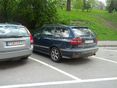
I drove to the hash in a Volvo V60 from the car sharing. I arrived about half past twelve and found the hash point close to the road. I put up a marker on a tree a few yards away and then hung around waiting to see if Cjk would turn up. I didn't want to leave before he arrived, because then he wouldn't also get the virgin graticule achievement.
After about an hour I was about to leave, but while I was building a little pile of branches to mark the hash point, Cjk and TheFasionStatement arrived. I had a quick piece of cheese with them and then I had to rush off. The car had to be back by 3 pm sharp. I won't upload my tracklog as it's probably incriminating ;)
Cjk and TheFashionStatement
Per S and I had talked about deflowering Kapellskär (it is like 99% ocean) last time we met at the hash on Utö and he found this one and sent a message via the wiki. Of course I was going. Headed off from home to pick up TheFasionStatement on the pretense that it was a road trip. And it turned out to be a nice one. The GPS in the phone was on the fritz all the way so turn off points where a bit hard to find. Got close to the right field after about an hours drive and Per S was already there, the little Early Bird that he is. Big thanks for waiting an hour for us at the hash.
He had put up a sign on the nearest tree and built a little mound of branches on the spot. I packed up a small picnic with cutlery from home and some cheese and hard bread, Gruyere and Saint Agur. Per S had to speed off so we took a quick group photo and he took off.
Stayed some more minutes and took more photos before heading back. Had late lunch at Max and then road tripped a bit through Danderyd looking at houses and imagining the people in them. Then home to Stockholm and a quick visit to the Army Museum.
Tracklog
- map of ride back to Stockholm via Max Hamburgers and a drive around Danderyd
Photos
Per S
Today's citation
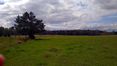
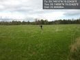
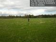
The Field
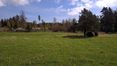
The Field
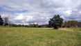
The Field
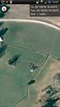
Coordinates Reached
The Hashpoint

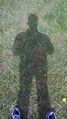
Geohasher
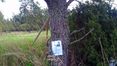
Marker
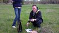
Picnic
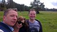
Geohashers


Cjk
Ready to take off.
TheFashionStatement
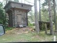
Structure and boat looked almost Viking.
TheFashionStatement at the hash.

Russian Circles
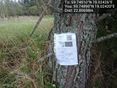
Hashtree
View of the hash
Orange™
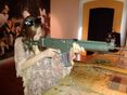
Some fun at the army museum.


Achievements
| |||||||||||
| |||||||||||
| |||||||||||
| |||||||||||
| |||||||||||
| |||||||||||
|