Difference between revisions of "2012-05-22 32 -116"
From Geohashing
imported>LucasBrown |
imported>FippeBot m (Location) |
||
| (2 intermediate revisions by 2 users not shown) | |||
| Line 16: | Line 16: | ||
== Participants == | == Participants == | ||
[[User:LucasBrown|LucasBrown]] | [[User:LucasBrown|LucasBrown]] | ||
| − | |||
| − | |||
| − | |||
== Photos == | == Photos == | ||
| Line 39: | Line 36: | ||
[[Category:Expeditions]] | [[Category:Expeditions]] | ||
[[Category:Expeditions with photos]] | [[Category:Expeditions with photos]] | ||
| + | [[Category:Coordinates reached]] | ||
| + | {{location|US|CA|SD}} | ||
Latest revision as of 04:09, 13 August 2019
| Tue 22 May 2012 in 32,-116: 32.9432267, -116.9547973 geohashing.info google osm bing/os kml crox |
Location
About 100m north of the Foster Truck Trail near a plant nursery in the Iron Hills of Poway and Ramona
Participants
Photos
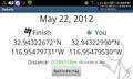
Geohash Droid screenshot at the hashpoint---details page @32.9432,-116.9548
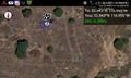
Geohash Droid screenshot at the hashpoint---satellite view @32.9432,-116.9548
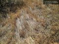
The hashpoint @32.9432,-116.9548


