Difference between revisions of "2012-05-24 38 -90"
imported>Kbh3rd m |
imported>Jiml m (Add result codes) |
||
| Line 11: | Line 11: | ||
[http://mdc4.mdc.mo.gov/applications/moatlas/AreaSummaryPage.aspx?txtAreaID=4901&txtAreaNm=busch&txtCounty=&txtRegion=&txtUserID=guest&txtDivision= August A. Busch Memorial Conservation Area] | [http://mdc4.mdc.mo.gov/applications/moatlas/AreaSummaryPage.aspx?txtAreaID=4901&txtAreaNm=busch&txtCounty=&txtRegion=&txtUserID=guest&txtDivision= August A. Busch Memorial Conservation Area] | ||
| − | |||
* N 38°41.717, W 90°47.733 | * N 38°41.717, W 90°47.733 | ||
| Line 18: | Line 17: | ||
== Participants == | == Participants == | ||
| − | *[[User:Kbh3rd]] | + | * [[User:Kbh3rd]] |
| − | |||
| − | |||
| − | |||
| − | |||
| − | |||
| − | |||
| − | |||
| − | |||
| − | + | == Plans == | |
| − | + | The first location in the short time I've been watching it that was on public land instead of being in someone's corn field (or in someone else's bean field). | |
Drive to Lake 28 in the conservation area, being just north of the site, and hike in. Route D is closer but has no parking. | Drive to Lake 28 in the conservation area, being just north of the site, and hike in. Route D is closer but has no parking. | ||
| Line 47: | Line 38: | ||
== Achievements == | == Achievements == | ||
| + | {{Prize poultry | ||
| + | | latitude = 38 | ||
| + | | longitude = -90 | ||
| + | | date = 2012-05-24 | ||
| + | | name = | ||
| + | | reason = of time and [http://en.wikipedia.org/wiki/Chiggers chiggers] | ||
| + | | image = 2012-05-24 38 -90 St Louis 1.jpg | ||
| + | |||
| + | }} | ||
[[Category:Expeditions]] | [[Category:Expeditions]] | ||
[[Category:Expeditions with photos]] | [[Category:Expeditions with photos]] | ||
| − | [[Category: | + | |
| − | [[Category: | + | [[Category:Coordinates not reached]] |
| + | [[Category:Not reached - Mother Nature]] | ||
Revision as of 23:12, 24 May 2012
| Thu 24 May 2012 in 38,-90: 38.6955044, -90.7957208 geohashing.info google osm bing/os kml crox |
Location
August A. Busch Memorial Conservation Area
- N 38°41.717, W 90°47.733
Participants
Plans
The first location in the short time I've been watching it that was on public land instead of being in someone's corn field (or in someone else's bean field).
Drive to Lake 28 in the conservation area, being just north of the site, and hike in. Route D is closer but has no parking.
Expedition
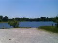
Drove to Lake 28. I was running late and wasn't prepared for the chigger hunt that would result from working around the lake and through the woods. So I called it close enough -- within spittin' distance.
As suggested by the lake number, there are many small fishing lakes in this conservation area. At one (number not remembered) I saw a Great Blue Heron flying low, both on the way in and on the way out. So got to see something cool even without making it within enough decimal places of the indicated location.
Photos
Nearby

Achievements
This user earned the Prize poultry Consolation Prize
|